- Australia ▾
- Topographic
▾
- Australia AUSTopo 250k (2024)
- Australia 50k Geoscience maps
- Australia 100k Geoscience maps
- Australia 250k Geoscience maps
- Australia 1.1m Geoscience maps
- New Zealand 50k maps
- New Zealand 250k maps
- New South Wales 25k maps
- New South Wales 50k maps
- New South Wales 100k maps
- Queensland 10k maps
- Queensland 25k maps
- Queensland 50k maps
- Queensland 100k maps
- Compasses
- Software
- GPS Systems
- Orienteering
- International ▾
- Wall Maps
▾
- World
- Australia & New Zealand
- Countries, Continents & Regions
- Historical
- Vintage National Geographic
- Australian Capital Territory
- New South Wales
- Northern Territory
- Queensland
- South Australia
- Tasmania
- Victoria
- Western Australia
- Celestial
- Children's
- Mining & Resources
- Wine Maps
- Healthcare
- Postcode Maps
- Electoral Maps
- Nautical ▾
- Flags
▾
- Australian Flag Sets & Banners
- Flag Bunting
- Handwavers
- Australian National Flags
- Aboriginal Flags
- Torres Strait Islander Flags
- International Flags
- Flagpoles & Accessories
- Australian Capital Territory Flags
- New South Wales Flags
- Northern Territory Flags
- Queensland Flags
- South Australia Flags
- Tasmania Flags
- Victoria Flags
- Western Australia Flags
- Gifts ▾
- Globes ▾
Dear valued customer. Please note that our checkout is not supported by old browsers. Please use a recent browser to access all checkout capabilities
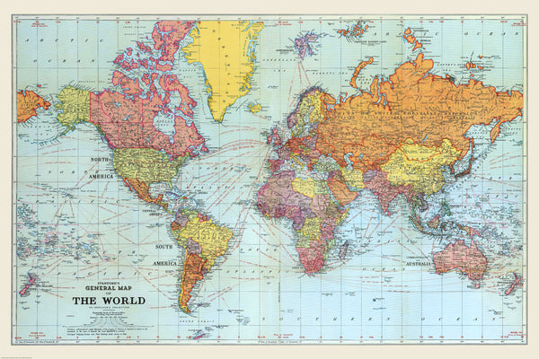
Stanford's General Map of the World (1920) Blue Version
$129.95
or make 4 interest-free payments of
$32.49 AUD
fortnightly with
![]() More info
More info
A Striking Historical World Map from the Edward Stanford Cartographic Archive – Reproduced in Rich Blue Tones
This elegant blue edition of Stanford’s General Map of the World, originally published in 1920, offers a remarkable window into the geopolitical landscape following World War I. Part of the Edward Stanford Cartographic Collection, this beautifully reproduced historical map reflects the shifting power structures and emerging national borders of a newly reordered world.
Designed in the unmistakable Stanford house style, the map displays colonial territories, League of Nations mandates, and imperial possessions, with the British Empire traditionally marked in red. The overall effect is both striking and informative—offering a unique mix of artistry and political documentation.
🗺️ Historical and Geographic Features
-
Published in 1920, immediately following the First World War
-
Highlights the British Empire, League of Nations mandates, and newly drawn borders
-
Includes colonial possessions, dominions, and protectorates with period-specific annotations
-
Shows mountain ranges, major rivers, and key topographical features across continents
-
Main railway routes are marked, providing insight into early 20th-century infrastructure
-
Ocean shipping lanes annotated with distances—a nod to the age of steamship travel
-
Features 15° latitude and longitude grid lines, with time zone references from the Greenwich Meridian
-
Projection: Mercator
This is not just a map—it's a historical document that captures a moment in time, rich with geopolitical nuance and early 20th-century cartographic style.
🖨️ Available Finishes
Choose from three premium finishes to suit your space and presentation preferences:
| Format | Description |
|---|---|
| 160gsm Paper | A heavyweight matte paper ideal for framing under glass |
| Encapsulated Laminate | Fully sealed in 80-micron gloss laminate (front and back), making it durable, waterproof, and marker-friendly |
| 395gsm Canvas | Printed on HP Professional Matte Canvas using fade-resistant pigment inks for a museum-quality finish. This is our most durable and elegant option for long-term display |
Optional Canvas Hang Rails
Laminated & Canvas versions can be fitted with natural timber hang rails, top and bottom, with a hanging cord pre-attached for effortless installation.
⏳ Please allow up to 10 working days for delivery of hang-railed canvas maps, as each is custom-finished by our framer.
📐 Specifications
| Attribute | Detail |
|---|---|
| Title | Stanford's General Map of the World – Blue Edition |
| Original Publisher | Edward Stanford Ltd., London |
| Year First Published | 1920 |
| Projection | Mercator |
| Size | 1440 mm (W) x 960 mm (H) |
| Print Material | 160gsm Paper / Laminated / 395gsm Canvas |
| Made In | Australia |
✅ Why Choose This Map?
| Feature | Benefit |
|---|---|
| Post-WWI world view | Understand how the world was redrawn after the Great War |
| Striking blue colourway | A distinctive alternative to traditional sepia-toned historical maps |
| Archival quality canvas option | Long-lasting and fade-resistant with a luxurious finish |
| Part of the Edward Stanford Archive | Reproduced from one of the world's great cartographic collections |
| Perfect for display | Ideal for study walls, libraries, offices, and classrooms |
Whether you're a history enthusiast, cartographic collector, or simply looking for a beautifully detailed wall piece, this 1920 Stanford's World Map is both a decorative and educational treasure. Its distinctive blue tones and period-accurate detail make it a standout piece for any room.


