A Glimpse into Victorian Britain’s Historic Counties | Archival Reproduction
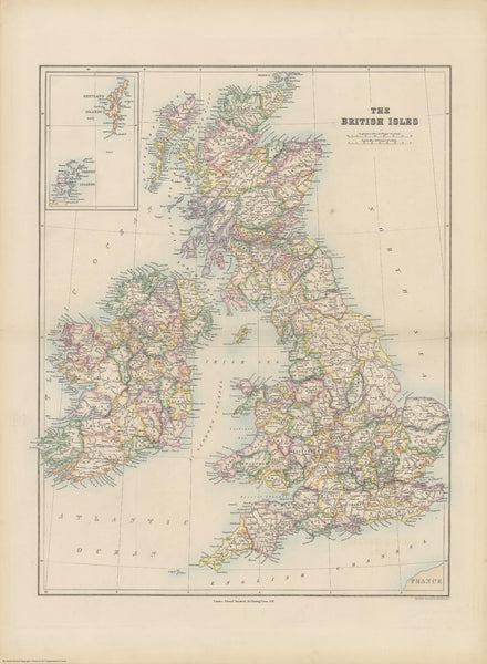
Step back in time with this beautifully reproduced British Isles Map, first published by Edward Stanford in 1884. Drawn during the late Victorian era, this map highlights the historic county boundaries of Great Britain and Ireland in bright colours against a soft pale background, making place names exceptionally clear and easy to read.
🗺️ Historical Detail & Charm
-
Historic County Borders: See the old county lines of the British Isles exactly as they were recorded in 1884—an invaluable reference for genealogists, historians, and those fascinated by the shifting administrative landscape of the UK and Ireland.
-
Rich Cartographic Features: True to Stanford’s meticulous style, this map includes an unusually large number of named small rivers—even the delicate meanders of the Cuckmere appear in print.
-
A Victorian Portrait of London: Notice how London appears as a much smaller footprint, still nestled mostly within Middlesex—a striking contrast to its present-day sprawl.
-
Ireland’s Counties Preserved: While Britain’s counties have undergone many administrative changes, the map reveals how Ireland’s historic borders remained comparatively stable—an interesting visual contrast across the Irish Sea.
🎨 Premium Printing & Materials
This map is available in three high-quality finishes:
| Format | Description |
|---|---|
| 160gsm Paper | Ideal for framing under glass. Smooth matte surface and crisp detail make it a timeless classic. |
| Laminated (Encapsulated) | Fully sealed between two sheets of 80-micron gloss laminate. Durable, waterproof, and perfect for spaces where you might handle or annotate the map. |
| 395gsm Matte Canvas | Printed on HP Professional Matte Canvas using pigment-based archival inks. Museum-grade quality, fade-resistant, and built to last for generations. |
🪵 Optional Timber Hang Rails
For a refined, ready-to-hang finish, choose either the laminated or canvas with timber hang rails. We attach lacquered natural timber battens top and bottom, along with a matching hanging cord—just place a hook on the wall and admire.
⏳ Please allow up to 10 working days for delivery of hang-railed maps, as these are individually prepared by our framer.
📐 Specifications
| Attribute | Detail |
|---|---|
| Title | Stanford’s Folio British Isles Map |
| Original Publication | 1884, Edward Stanford Ltd., London |
| Reproduction | Edward Stanford Cartographic Collection |
| Size | 547 mm (W) x 745 mm (H) |
| Printed In | Australia |
| Finish Options | Paper, Laminated, Canvas |
✅ Why Choose This Map?
| Feature | Benefit |
|---|---|
| Historic authenticity | A true snapshot of Britain & Ireland in 1884 |
| Bright, clear boundaries | Old counties shown in distinct colours for easy reference |
| Victorian era detail | Includes rivers, small towns, and place names often omitted on modern maps |
| Premium materials | Fade-resistant, museum-quality printing |
| Perfect for historians & collectors | An educational treasure and elegant décor piece |
🌏 Ideal For:
-
Genealogists researching family histories across the old counties
-
Historians or educators wanting a visual reference for Victorian-era Britain and Ireland
-
Interior designers or collectors seeking a tasteful antique-style focal point
-
Gifts for map enthusiasts, lovers of British history, or Anglophiles
Capture the rich tapestry of 19th-century Britain and Ireland with this elegant and historically significant map—an enduring testament to the art of cartography and the stories of the lands it so beautifully depicts.
Made in Australia – Crafted to Last.


