Reproduced from the original by the New Zealand Department of Lands and Survey
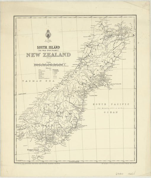
Step back into the early 20th century with this beautifully restored historic wall map of New Zealand’s South Island, originally published in 1926 by the New Zealand Department of Lands and Survey. This map captures the South Island as it was nearly a century ago—showcasing topographic features, colonial-era place names, early infrastructure, and political boundaries with exquisite detail and vintage cartographic style.
An ideal piece for history enthusiasts, collectors, educators, or anyone with a love for New Zealand’s past, this map is available in a range of premium formats, each produced to museum-quality standards.
🗺️ A Window into the South Island of 1926
This map reveals a South Island that was still deeply shaped by its geography and colonial heritage. You’ll see a landscape defined by its alpine ranges, expansive plains, glacial lakes, and winding rivers—many of which remain unchanged today. But alongside these natural landmarks, you'll also spot the historical boundaries of counties, roads and rail lines under construction, early townships, and cartographic features now lost to time.
The aesthetic is classic and authoritative, printed in the hallmark style of early 20th-century land survey maps. Whether you’re tracing ancestral roots, decorating a heritage space, or simply admiring the evolution of place, this map brings history vividly to life.
📐 Map Specifications
| Specification | Details |
|---|---|
| Original Title | South Island of New Zealand |
| Published By | New Zealand Department of Lands and Survey |
| Year of Publication | 1926 |
| Map Dimensions | 950 mm (width) x 811 mm (height) |
| Available Finishes | Paper, Laminated, or Matte Canvas |
| Printing | High-resolution reproduction |
| Crafted In | Proudly made and finished in Australia |
Choose from Three Premium Formats
🖨️ 1. Heavyweight Paper (160gsm Matte)
-
A clean, traditional presentation of the map.
-
Perfect for framing under glass or mounting behind acrylic.
-
Offers crisp detail with a smooth, non-glare finish.
-
Ideal for libraries, home offices, classrooms, or archival collections.
💧 2. Laminated Version (Encapsulated Gloss)
-
Encapsulated between two layers of 80-micron gloss laminate, providing a durable, protective barrier.
-
Water-resistant and tear-proof—great for environments where the map will be handled or marked regularly.
-
Dry-erase friendly: Use whiteboard markers for planning, teaching, or annotating locations.
-
Ideal for educational settings, public displays, or professional use.
🖼️ 3. Matte Canvas (395gsm Professional Canvas)
-
Printed using pigment-based archival inks for stunning colour clarity and fade resistance.
-
The canvas texture enhances the map’s vintage look and gives it a museum-quality finish.
-
Delivered either rolled for custom framing or ready-to-hang with timber hang rails.
🪵 Optional Timber Hang Rails (Laminated & Canvas Only)
For a stylish, gallery-ready presentation, choose the canvas format with natural timber hang rails:
-
Attached to the top and bottom of the map.
-
Lacquered in a warm natural finish to complement traditional or contemporary interiors.
-
Includes a top cord for quick and easy wall hanging.
Note: Hang-railed canvas maps are assembled by our professional framer. Please allow up to 10 working days for dispatch.
🛠️ Customisation Available
Do you need a more specific focus? We can produce custom region-specific enlargements, alternate sizes, or digitally annotate your map with:
-
Historical overlays
-
Property boundaries
-
Heritage trail routes
-
Council or electoral boundaries
Contact us for custom cartographic services tailored to collectors, historians, local councils, or commercial displays.
🎯 Perfect For:
-
Interior designers looking for a heritage centrepiece
-
Genealogists tracing family connections to early New Zealand settlements
-
Educators teaching geography or colonial history
-
Cartographic enthusiasts and collectors of antique maps
-
Businesses, galleries, or museums requiring a historic New Zealand feature wall
🇦🇺 Crafted with Care in Australia
Every map is printed, finished, and packaged right here in Australia using high-quality materials and professional standards. Whether displayed in a boardroom, study, school, or heritage home, this historic map is designed to last for generations.
🛒 Order Yours Today
Bring the timeless beauty of early New Zealand cartography into your space with this stunning South Island Historic Wall Map – 1926 Edition.
Available in Paper, Laminated, or Canvas. Choose your preferred size and finish from the dropdown menu above and enjoy a truly distinguished piece of Australasia's past.
Elegant. Informative. Enduring.
A rare piece of New Zealand’s history—restored, reproduced, and ready to display.


