- Australia ▾
- Topographic
▾
- Australia AUSTopo 250k (2025)
- Australia 50k Geoscience maps
- Australia 100k Geoscience maps
- Australia 250k Geoscience maps
- Australia 1:1m Geoscience maps
- New Zealand 50k maps
- New Zealand 250k maps
- New South Wales 25k maps
- New South Wales 50k maps
- New South Wales 100k maps
- Queensland 10k maps
- Queensland 25k maps
- Queensland 50k maps
- Queensland 100k maps
- Western Australia 25k maps
- Western Australia 50k maps
- Western Australia 100k maps
- Compasses
- Software
- GPS Systems
- International ▾
- Wall Maps
▾
- World
- Australia & New Zealand
- Countries, Continents & Regions
- Historical
- Vintage National Geographic
- Australian Capital Territory
- New South Wales
- Northern Territory
- Queensland
- South Australia
- Tasmania
- Victoria
- Western Australia
- Celestial
- Children's
- Mining & Resources
- Wine Maps
- Healthcare
- Postcode Maps
- Electoral Maps
- Nautical ▾
- Flags
▾
- Australian Flag Sets & Banners
- Flag Bunting
- Handwavers
- Australian National Flags
- Aboriginal Flags
- Torres Strait Islander Flags
- International Flags
- Flagpoles & Accessories
- Australian Capital Territory Flags
- New South Wales Flags
- Northern Territory Flags
- Queensland Flags
- South Australia Flags
- Tasmania Flags
- Victoria Flags
- Western Australia Flags
- Gifts ▾
- Globes ▾
Dear valued customer. Please note that our checkout is not supported by old browsers. Please use a recent browser to access all checkout capabilities


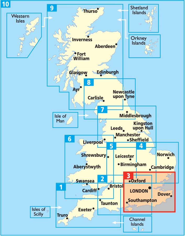
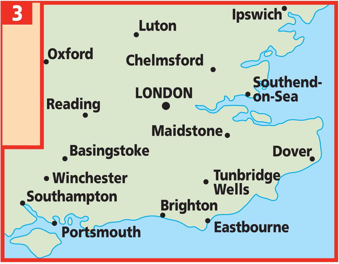
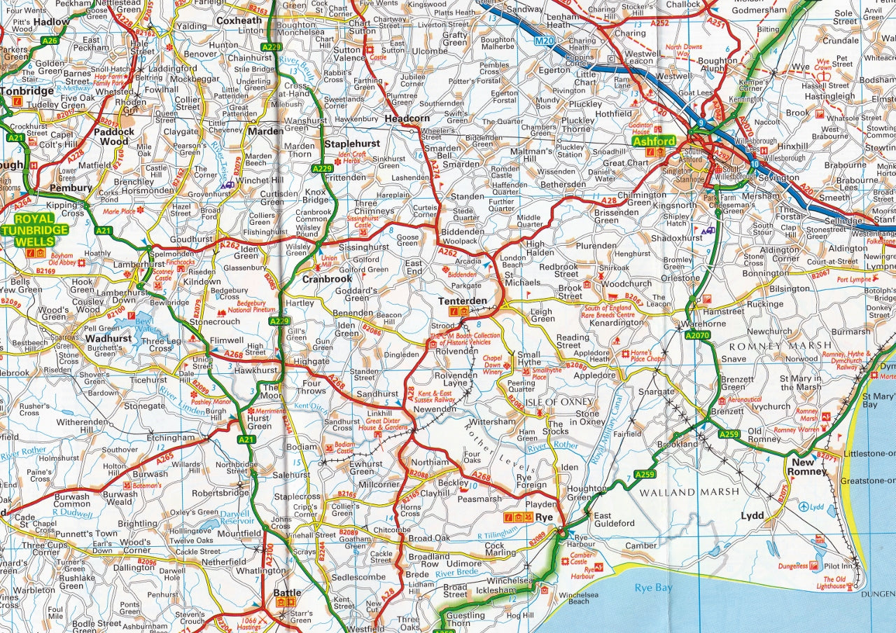
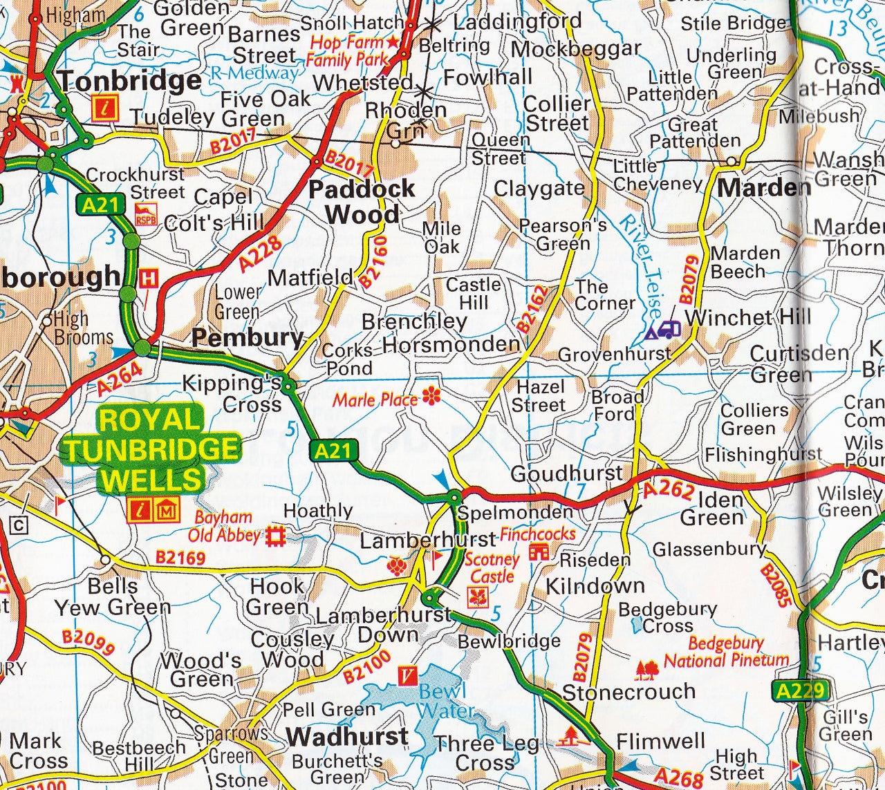
South East England AA Road Map 3
$19.95
Afterpay is only available for orders between $50.00 and $1000.00 More info
A Fold-Out Travel Companion with Heritage Sites, National Parks & In-Depth Town Plans
Scale: 1:200,000 | Size: 1200 mm x 980 mm | Format: Folded Paper Map
Discover the Best of South East England – With Confidence and Clarity
Whether you’re winding through the chalky Downs, navigating the coastlines of Kent and Sussex, or finding your way through London’s outer orbit, the AA South East England Road Map provides everything you need in one smart, practical package. Beautifully rendered and easy to fold, it’s the essential navigator’s tool—compact enough to fit in your glovebox or daypack, yet packed with detail for stress-free travel planning.
This latest 2024 edition has been comprehensively updated and reviewed by Britain's most trusted motoring organisation, the AA (Automobile Association). It offers not only precision and clarity but insight—highlighting everything from caravan sites and service areas to scenic heritage routes and top attractions.
🛣️ Comprehensive Road Detail
The AA is famous for its clear and detailed mapping, and this edition is no exception. It features:
-
Motorways & A-roads for rapid navigation
-
Minor & rural roads, perfect for leisurely drives
-
Road numbers, fuel stations, service areas, and toll points
-
Dual carriageways and trunk routes clearly distinguished
-
Distance markers and travel estimates for route planning
-
Ferry routes and rail connections for seamless multi-modal travel
🏕️ Points of Interest & Tourist Highlights
From the historic dockyards of Portsmouth to the ancient spires of Canterbury, from the dramatic white cliffs of Dover to the buzzing promenades of Brighton, this map marks:
-
National Parks & Areas of Outstanding Natural Beauty
-
Camping & caravan sites
-
English Heritage, National Trust & local historic sites
-
Scenic lookouts, parks, gardens, and museums
-
Walking routes and cycle trails
🏙️ Included Town & City Inset Maps
At a more detailed scale, this map includes 10 inset plans of key towns and cities, ideal for navigating central areas, one-way systems, parking, and points of interest.
| Town/City Included |
|---|
| London |
| Brighton |
| Canterbury |
| Dover |
| Eastbourne |
| Luton |
| Maidstone |
| Milton Keynes |
| Reading |
| Tunbridge Wells |
Each map includes major roads, street names, landmarks, and key facilities such as hospitals, train stations, and tourist hubs.
🚨 Safety Features & Navigation Aids
-
📍 Updated speed camera locations
-
⚠️ Speed limit annotations for enhanced road awareness
-
🧭 Clear place name index for fast referencing
-
📏 Mileage chart and scale bar to help estimate journey lengths
🌧️ Built for the British Weather
Encased in a weather-resistant and tear-resistant cover, this map is made to withstand folding, refolding, and repeated use. It’s perfect for on-the-road referencing, even in the middle of a drizzly lay-by or a windy picnic stop.
📐 Product Specifications
| Feature | Details |
|---|---|
| Publisher | AA (Automobile Association) |
| Format | Folded paper map with durable cover |
| Scale | 1:200,000 (3 miles to 1 inch / 2 km to 1 cm) |
| Size (Open) | 1200 mm x 980 mm |
| Size (Folded) | Compact – fits glovebox or backpack |
| Edition | 2024 |
| Weight | Lightweight and travel-ready |
| Language | English |
✅ Why Choose This Map?
✔️ Trust the Experts – Produced by the UK’s leading motoring authority
✔️ Precision Mapping – Clearly defined roads, parks, and towns
✔️ Comprehensive Planning Tool – Ideal for business logistics, holidays, or relocation
✔️ Compact Yet Powerful – Detailed and readable, yet travel-sized
✔️ Perfect Gift – A thoughtful present for travellers, history buffs, or caravanners
🎯 Perfect For:
-
🚗 Road trippers and holidaymakers exploring the Garden of England
-
🏞️ Campers, caravanners, and glampers planning overnight stays
-
🧭 Professional drivers or logistics coordinators needing clear routes and postcode access
-
🧳 Tourists and culture lovers following historical trails or scenic byways
-
📚 Teachers or students researching UK geography or local heritage
Plan it. Trace it. Discover it.
The AA South East England Road Map 3 is more than a simple navigation aid—it’s your all-in-one regional travel guide, tour planner, and on-the-road companion. Pack it with your boots, unfold it with your coffee, and let your next adventure begin.
Frequently Asked Questions
What area does the South East England AA Road Map 3 cover?
The South East England AA Road Map 3 provides road coverage of the region named in the product title. The map covers major cities, highways, towns, and regional roads, with inset city maps for key urban centres where applicable.
Is the South East England AA Road Map 3 up to date?
Yes, this is the current edition. Mapworld stocks the most current editions from all major publishers, updated to reflect new roads and infrastructure.
What size is this map when unfolded?
Folded maps from Mapworld's range are compact and portable. Most standard folded road or travel maps open to between A1 (594 × 841mm) and A0 (841 × 1189mm) when fully unfolded, and fold down to approximately A4 or smaller for easy storage in a glove box, bag, or backpack.
Is the South East England AA Road Map 3 in stock at Mapworld?
Mapworld maintains extensive stock across its map range and aims for fast dispatch. Orders placed before 2pm AEST on business days are typically dispatched the same day, with standard and express Australia-wide delivery options available.
Does Mapworld ship the South East England AA Road Map 3 across Australia?
Yes, Mapworld ships Australia-wide. Standard shipping is a flat $7 rate, with free standard shipping on orders over $75. Express options are available at checkout. Most orders placed before 2pm AEST on weekdays are dispatched same day.
Related Items


© 2026 Mapworld. Website designed by Genie Media
X