- Australia ▾
- Topographic
▾
- Australia AUSTopo 250k (2024)
- Australia 50k Geoscience maps
- Australia 100k Geoscience maps
- Australia 250k Geoscience maps
- Australia 1.1m Geoscience maps
- New Zealand 50k maps
- New Zealand 250k maps
- New South Wales 25k maps
- New South Wales 50k maps
- New South Wales 100k maps
- Queensland 10k maps
- Queensland 25k maps
- Queensland 50k maps
- Queensland 100k maps
- Compasses
- Software
- GPS Systems
- Orienteering
- International ▾
- Wall Maps
▾
- World
- Australia & New Zealand
- Countries, Continents & Regions
- Historical
- Vintage National Geographic
- Australian Capital Territory
- New South Wales
- Northern Territory
- Queensland
- South Australia
- Tasmania
- Victoria
- Western Australia
- Celestial
- Children's
- Mining & Resources
- Wine Maps
- Healthcare
- Postcode Maps
- Electoral Maps
- Nautical ▾
- Flags
▾
- Australian Flag Sets & Banners
- Flag Bunting
- Handwavers
- Australian National Flags
- Aboriginal Flags
- Torres Strait Islander Flags
- International Flags
- Flagpoles & Accessories
- Australian Capital Territory Flags
- New South Wales Flags
- Northern Territory Flags
- Queensland Flags
- South Australia Flags
- Tasmania Flags
- Victoria Flags
- Western Australia Flags
- Gifts ▾
- Globes ▾
Dear valued customer. Please note that our checkout is not supported by old browsers. Please use a recent browser to access all checkout capabilities


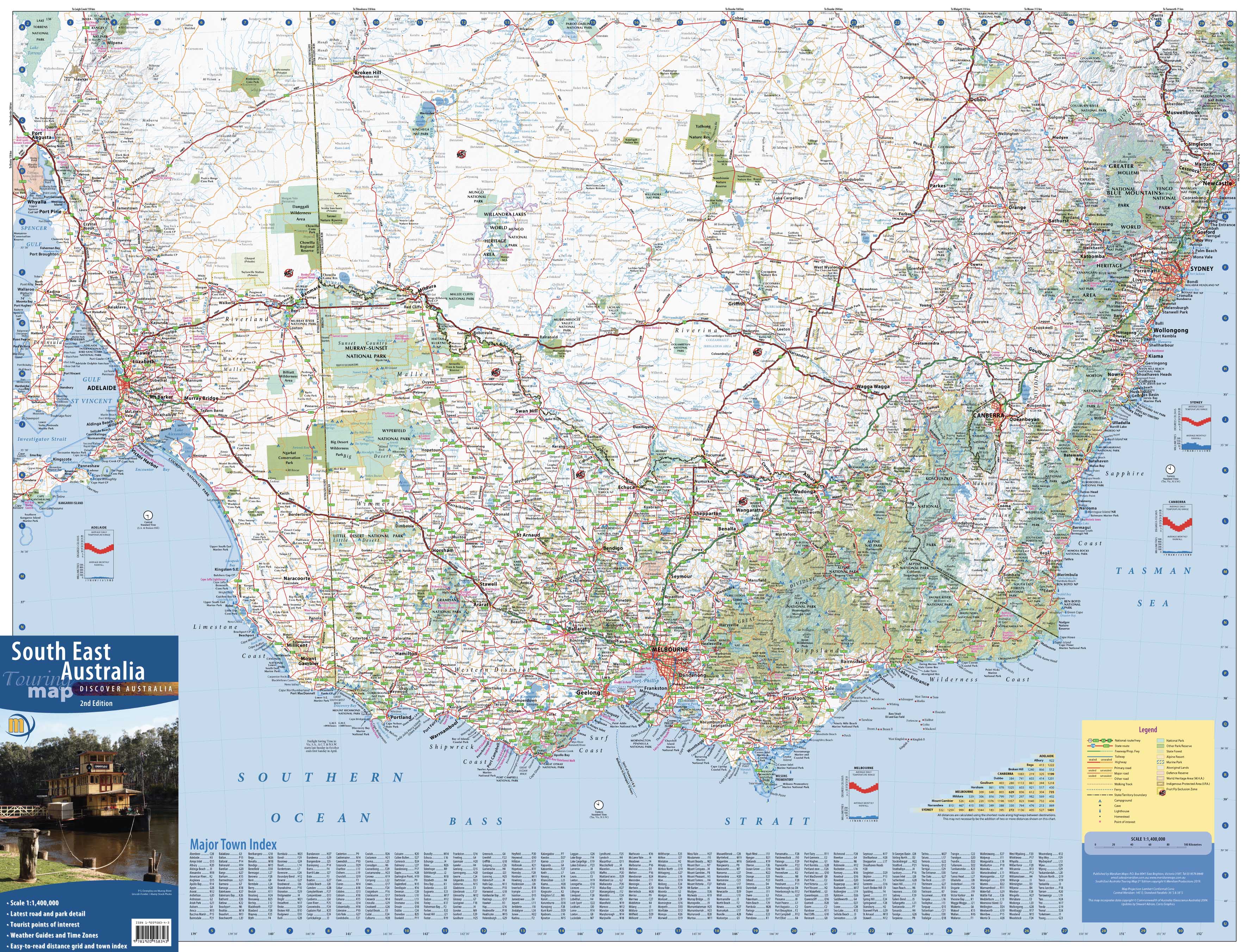
South East Australia Meridian 1005 x 815mm Wall Map
$99.95
or make 4 interest-free payments of
$24.99 AUD
fortnightly with
![]() More info
More info
Meridian Maps | 1005 x 815 mm | Scale 1:1,400,000
Covering Australia’s most dynamic and densely populated region, the South East Australia Wall Map by Meridian Maps is an essential reference for businesses, travellers, educators, and home offices alike. Stretching from Adelaide in the west to Newcastle in the north—and encompassing Melbourne, Canberra, Sydney, and all of Victoria—this expansive map delivers exceptional clarity, practical features, and elegant design.
Coverage Area
This map captures the southeastern corner of the country with a focus on real-world navigation rather than state boundaries. It includes:
-
All of Victoria
-
Southeastern South Australia (including Adelaide)
-
Southern New South Wales (extending past Newcastle)
-
Major road, rail and highway corridors connecting capital cities
-
Key regional centres, inland highways, and coastal access routes
Practical Features for Everyday Use
Whether you're a logistics manager plotting delivery routes or a family planning the next road trip, this map is built for real-world application:
| Feature | Description |
|---|---|
| 🧭 Distance Grid | Quickly calculate travel distances between key towns and cities |
| ⏱️ Road Travel Time Guide | Estimate driving times across major corridors |
| 🌏 Uncluttered Design | Focused mapping with no intrusive political boundaries |
| 🗺️ Geographic Detail | Rivers, terrain shading, and urban centres shown with clarity |
This is a large-format reference map designed for pinpoint accuracy and professional clarity.
Premium Print & Material Options
Choose the finish that suits your needs and space:
✅ Paper Version (160gsm)
-
Ideal for framing behind glass
-
Crisp, detailed printing on heavyweight coated stock
✅ Laminated Version (Encapsulated)
-
Printed on 160gsm stock, then fully encapsulated in 2 x 80-micron gloss laminate
-
Write-on/wipe-off surface—use whiteboard markers or Map Dots
-
Highly durable for frequent use in offices, classrooms, and workshops
- Optional timber hang rails in natural lacquered finish, with top cord for effortless hanging
✅ Canvas Version (395gsm HP Matte Canvas)
-
Printed using pigment-based inks for long-term fade resistance
-
Museum-quality clarity with a tactile, fabric finish
-
Optional timber hang rails in natural lacquered finish, with top cord for effortless hanging
NOTE: Please allow up to 10 working days for delivery of hang-railed versions
📐 Specifications
| Attribute | Value |
|---|---|
| Publisher | Meridian Maps |
| Map Title | South East Australia Wall Map |
| Size | 1005 mm (W) x 815 mm (H) |
| Scale | 1:1,400,000 |
| Format Options | Paper, Laminated, or Canvas |
| Region | VIC, SE SA, ACT, Southern NSW |
Who Is This Map For?
-
Businesses: Plot customer locations, delivery zones, service areas
-
Educators: Teach geography, regional planning, and social studies
-
Travellers: Plan and visualise long-distance road trips across states
-
Home Offices: Add a functional and stylish feature to your wall
Why Choose a Meridian Map?
With a reputation for cartographic excellence, Meridian Maps creates some of Australia’s most dependable and beautiful wall maps. Their South East Australia edition combines function with visual appeal—equally suited to a boardroom wall or above your garage workbench.
Plan better. Travel smarter. Explore further.
Let your next journey—professional or personal—start here.
