- Australia ▾
- Topographic
▾
- Australia AUSTopo 250k (2025)
- Australia 50k Geoscience maps
- Australia 100k Geoscience maps
- Australia 250k Geoscience maps
- Australia 1:1m Geoscience maps
- New Zealand 50k maps
- New Zealand 250k maps
- New South Wales 25k maps
- New South Wales 50k maps
- New South Wales 100k maps
- Queensland 10k maps
- Queensland 25k maps
- Queensland 50k maps
- Queensland 100k maps
- Western Australia 25k maps
- Western Australia 50k maps
- Western Australia 100k maps
- Compasses
- Software
- GPS Systems
- International ▾
- Wall Maps
▾
- World
- Australia & New Zealand
- Countries, Continents & Regions
- Historical
- Vintage National Geographic
- Australian Capital Territory
- New South Wales
- Northern Territory
- Queensland
- South Australia
- Tasmania
- Victoria
- Western Australia
- Celestial
- Children's
- Mining & Resources
- Wine Maps
- Healthcare
- Postcode Maps
- Electoral Maps
- Nautical ▾
- Flags
▾
- Australian Flag Sets & Banners
- Flag Bunting
- Handwavers
- Australian National Flags
- Aboriginal Flags
- Torres Strait Islander Flags
- International Flags
- Flagpoles & Accessories
- Australian Capital Territory Flags
- New South Wales Flags
- Northern Territory Flags
- Queensland Flags
- South Australia Flags
- Tasmania Flags
- Victoria Flags
- Western Australia Flags
- Gifts ▾
- Globes ▾
Dear valued customer. Please note that our checkout is not supported by old browsers. Please use a recent browser to access all checkout capabilities


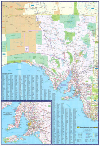
South Australia State & Suburban UBD 570 Map
$13.95
Afterpay is only available for orders between $50.00 and $1000.00 More info
A richly detailed and highly practical map of South Australia — perfect for planning, navigation, and display.
The UBD Gregory’s South Australia State and Suburban Map is a dual-sided, full-colour wall map that offers an exceptional combination of broad regional overview and metropolitan street-level detail. Designed for clarity, durability, and ease of use, this map is ideal for business planning, education, logistics, travel preparation, or home reference.
Whether you're pinpointing destinations across the outback, coast, or wine regions, or navigating through Adelaide’s metro sprawl, this map provides all the information you need — backed by UBD’s decades of trusted cartographic experience.
🗺️ Side One – South Australia State Map
Covers the entire state of South Australia in one cohesive view, including:
-
Clearly marked roads: national highways, secondary roads, and dual carriageways
-
Regional centres and rural towns: from Ceduna to Mount Gambier, Coober Pedy to Renmark
-
Index of major and minor towns for quick referencing
-
Physical features including major rivers, lakes, mountain ranges, and desert zones
-
Boundaries: state lines, council regions, and national parks
-
Points of interest: outback stations, ferry routes, roadhouses, remote communities
From the vast arid heart of the Outback North to the cooler climes of the Adelaide Hills and Fleurieu Peninsula, this side of the map paints a vivid picture of South Australia’s scale and diversity.
🏙️ Side Two – Greater Adelaide & Suburbs
Offers a detailed view of Adelaide’s suburban sprawl, showing:
-
Street-level clarity from Gawler in the north to Aldinga Beach in the south
-
Major arterial routes and motorways such as the Northern Connector, South Road, and Southern Expressway
-
Residential zones, industrial estates, and coastal developments
-
Postcodes marked for every suburb and a corresponding index for easy lookup
-
National parks and nature reserves, including Belair, Onkaparinga, and Cobbler Creek
-
Detailed inset of the Barossa Valley, one of Australia’s premier wine tourism regions
This side is perfect for navigating the greater metropolitan area — whether you're house hunting, planning deliveries, or exploring Adelaide's many suburbs.
🌄 Discover South Australia – A State of Extremes
The map also serves as a visual introduction to one of Australia's most fascinating states. South Australia is:
-
Home to more than 300 conservation parks and national parks, covering over 20% of the state’s land area
-
Crisscrossed with iconic 4WD tracks, including the Oodnadatta Track, Strzelecki Track, and Googs Track
-
A cultural powerhouse, hosting world-renowned events like the Adelaide Festival, WOMADelaide, and SALA Festival
-
World-famous for its wine regions — Barossa Valley, McLaren Vale, Clare Valley, Coonawarra
-
Rich in natural features — from the Flinders Ranges and Lake Eyre Basin to the Murray River and Great Australian Bight
The map supports regional tourism, cultural education, and environmental appreciation, making it as informative as it is useful.
🖨️ Premium Materials & Format
Printed on high-quality 120 gsm paper, this map is:
-
Fully encapsulated in two sheets of 80-micron gloss laminate
-
Water- and tear-resistant
-
Writable with whiteboard markers
-
Suitable for pins, Map Dots, or Velcro tabs
-
Easy to clean and long-lasting — perfect for high-traffic or high-use environments
📐 Specifications
-
Scale:
-
State Map: 1:1,900,000
-
Adelaide Suburbs: 1:100,000
-
-
Size: 700 mm (W) × 1000 mm (H)
-
Orientation: Portrait
-
Edition: 2023
-
Printed & Published: In Australia by UBD Gregory’s
🛒 Available Purchase Options
-
Flat laminated map – $99.00
-
Smooth finish, ideal for wall mounting or framing
-
Recommended for business, education, or professional display
-
-
Laminated folded map – $49.95
-
Flattened and laminated after folding; some minor crease lines may be visible
-
A practical and affordable solution for daily use or personal reference
-
Optional wooden hang rails available - Please allow up to 10 working days for custom hang-railed maps.
🎯 Ideal For
-
Business logistics and regional operations
-
Tourism operators and travel consultants
-
Teachers and students studying Australian geography
-
Town planners, architects, and property developers
-
Real estate agencies and moving professionals
-
Home offices and map enthusiasts
Whether you're charting deliveries across the state, teaching classroom geography, planning your next outback adventure, or simply admiring the contours of this incredible land — the UBD Gregory’s South Australia State & Suburban Map is your ultimate reference.
Clear. Durable. Thorough. Entirely South Australian.
Frequently Asked Questions
Where can I buy the South Australia State & Suburban UBD 570 Map?
The South Australia State & Suburban UBD 570 Map is available to buy online from Mapworld, Australia's largest map and geographic product retailer, with fast shipping Australia-wide.
Is the South Australia State & Suburban UBD 570 Map in stock at Mapworld?
Mapworld maintains extensive stock across its map range and aims for fast dispatch. Orders placed before 2pm AEST on business days are typically dispatched the same day, with standard and express Australia-wide delivery options available.
What is Mapworld's returns policy?
Mapworld accepts returns on undamaged items in original condition. Contact Mapworld within 90 days of purchase to arrange a return or exchange.
Does Mapworld ship the South Australia State & Suburban UBD 570 Map across Australia?
Yes, Mapworld ships Australia-wide. Standard shipping is a flat $7 rate, with free standard shipping on orders over $75. Express options are available at checkout. Most orders placed before 2pm AEST on weekdays are dispatched same day.
Related Items


© 2026 Mapworld. Website designed by Genie Media
X