- Australia ▾
- Topographic
▾
- Australia AUSTopo 250k (2025)
- Australia 50k Geoscience maps
- Australia 100k Geoscience maps
- Australia 250k Geoscience maps
- Australia 1:1m Geoscience maps
- New Zealand 50k maps
- New Zealand 250k maps
- New South Wales 25k maps
- New South Wales 50k maps
- New South Wales 100k maps
- Queensland 10k maps
- Queensland 25k maps
- Queensland 50k maps
- Queensland 100k maps
- Compasses
- Software
- GPS Systems
- Orienteering
- International ▾
- Wall Maps
▾
- World
- Australia & New Zealand
- Countries, Continents & Regions
- Historical
- Vintage National Geographic
- Australian Capital Territory
- New South Wales
- Northern Territory
- Queensland
- South Australia
- Tasmania
- Victoria
- Western Australia
- Celestial
- Children's
- Mining & Resources
- Wine Maps
- Healthcare
- Postcode Maps
- Electoral Maps
- Nautical ▾
- Flags
▾
- Australian Flag Sets & Banners
- Flag Bunting
- Handwavers
- Australian National Flags
- Aboriginal Flags
- Torres Strait Islander Flags
- International Flags
- Flagpoles & Accessories
- Australian Capital Territory Flags
- New South Wales Flags
- Northern Territory Flags
- Queensland Flags
- South Australia Flags
- Tasmania Flags
- Victoria Flags
- Western Australia Flags
- Gifts ▾
- Globes ▾
Dear valued customer. Please note that our checkout is not supported by old browsers. Please use a recent browser to access all checkout capabilities


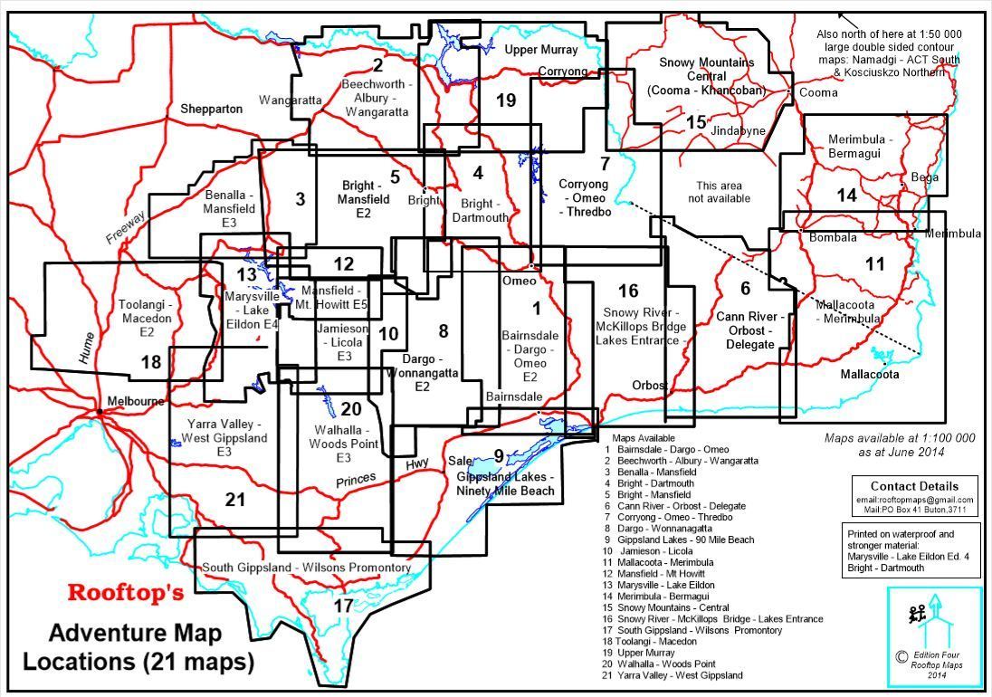
Snowy River, McKillops Bridge, Lakes Entrance Adventure Map Rooftop
$12.95 $14.95
Afterpay is only available for orders between $50.00 and $1000.00 More info
Main Scale: 1:100,000 | Reverse Map: 1:50,000 | GPS Mapped | Optional Lamination Available
Explore one of Australia's most spectacular wilderness regions with this detailed Adventure Map from Rooftop Maps. Covering the majestic Snowy River, the dramatic terrain around McKillops Bridge, and the scenic coastal reaches of Lakes Entrance, this double-sided map is an essential tool for four-wheel drivers, campers, paddlers, bushwalkers, and outdoor adventurers of all stripes.
📍 Area Coverage Includes:
-
Towns & Regions:
Johnsonville, Swan Reach, Lakes Entrance, Lake Tyers, Nowa Nowa, Ewings Marsh, Orbost, Buchan, Bruthen, Numerella, Ensay, Marlo, and Corringle Beach -
Parks & Forests:
Snowy River National Park, Alpine National Park, Great Alpine Road, and adjacent reserves and state forests -
Adventure Highlights:
Deddick Trail, McKillops Bridge, Snowy River whitewater sections, forest tracks, camping areas, and remote trailheads
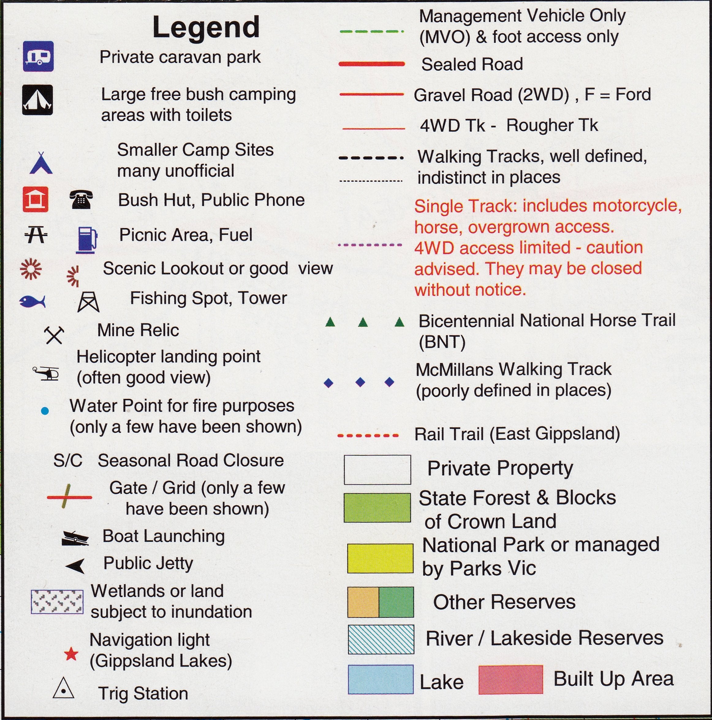
🧭 Map Features
-
Main Map (Front):
Regional map at 1:100,000 scale, clearly showing major and minor roads, 4WD tracks, watercourses, terrain features, parks and forests, and townships. -
Inset Map (Reverse):
The Snowy River – Buchan Forest Activities Map at 1:50,000 scale, complete with contour lines for terrain navigation. Ideal for more detailed trip planning in the core wilderness areas. -
River & Rapids Detail:
The Snowy River, from McKillops Bridge to Buchan, has been meticulously mapped, including:-
Campsites along the river
-
~95 distinct rapids, each graded by difficulty — a vital reference for paddlers and safety-conscious explorers
-
-
GPS-Plotted Accuracy:
All roads, tracks, rivers, and trails have been field-verified and GPS-plotted for precision. You can rely on this map even in remote, signal-free terrain.
🏕️ Ideal For:
-
🚙 4WD Adventures
-
🥾 Bushwalking & Trekking
-
🛶 Kayaking & Canoeing
-
🏞️ National Park Touring
-
🌲 Forest Exploration & Camping
-
🧭 Backcountry Navigation
Optional Lamination Available
Upgrade your map with professional lamination for enhanced durability and usability. Laminated maps:
-
Can be marked with whiteboard markers and cleaned with a dry cloth
-
Accept map dots to highlight your favourite locations without permanent marks
-
Resist moisture, tearing, dirt, and general wear – perfect for rugged field use
📌 Note: Laminated versions are created by flattening and encapsulating a folded map in two sheets of 80-micron gloss laminate. Some faint fold lines may remain visible.
📐 Product Specifications
| Feature | Details |
|---|---|
| Title | Snowy River, McKillops Bridge & Lakes Entrance Adventure Map |
| Publisher | Rooftop Maps |
| Main Scale | 1:100,000 |
| Inset Scale | 1:50,000 (Snowy River – Buchan detail map) |
| Map Type | Double-sided, topographic adventure map |
| Size (opened) | 700 mm (w) x 1000 mm (h) |
| Mapping Method | GPS-plotted and field-checked |
| Rapids Grading | ~95 rapids shown, graded by difficulty |
| Finish Options | Paper or Laminated |
| Edition | Latest available |
| Made In | Australia 🇦🇺 |
🛒 Add to Cart Today
Whether you’re navigating rugged 4WD tracks, planning a canoe descent down the Snowy, or simply looking for a reliable regional map packed with detail, the Rooftop Adventure Map of the Snowy River, McKillops Bridge & Lakes Entrance is your ultimate backcountry companion.
Get yours now and experience Victoria’s high country the way it was meant to be seen — wild, remote, and unforgettable.


