- Australia ▾
- Topographic
▾
- Australia AUSTopo 250k (2024)
- Australia 50k Geoscience maps
- Australia 100k Geoscience maps
- Australia 250k Geoscience maps
- Australia 1.1m Geoscience maps
- New Zealand 50k maps
- New Zealand 250k maps
- New South Wales 25k maps
- New South Wales 50k maps
- New South Wales 100k maps
- Queensland 10k maps
- Queensland 25k maps
- Queensland 50k maps
- Queensland 100k maps
- Compasses
- Software
- GPS Systems
- Orienteering
- International ▾
- Wall Maps
▾
- World
- Australia & New Zealand
- Countries, Continents & Regions
- Historical
- Vintage National Geographic
- Australian Capital Territory
- New South Wales
- Northern Territory
- Queensland
- South Australia
- Tasmania
- Victoria
- Western Australia
- Celestial
- Children's
- Mining & Resources
- Wine Maps
- Healthcare
- Postcode Maps
- Electoral Maps
- Nautical ▾
- Flags
▾
- Australian Flag Sets & Banners
- Flag Bunting
- Handwavers
- Australian National Flags
- Aboriginal Flags
- Torres Strait Islander Flags
- International Flags
- Flagpoles & Accessories
- Australian Capital Territory Flags
- New South Wales Flags
- Northern Territory Flags
- Queensland Flags
- South Australia Flags
- Tasmania Flags
- Victoria Flags
- Western Australia Flags
- Gifts ▾
- Globes ▾
Dear valued customer. Please note that our checkout is not supported by old browsers. Please use a recent browser to access all checkout capabilities


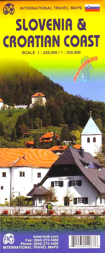
Croatian Coast & Slovenia ITMB Map
$24.95
Afterpay is only available for orders between $50.00 and $1000.00 More info
Double-Sided Map Featuring Slovenia and the Dalmatian Coast of Croatia
Map Size: 686 mm x 991 mm
Printed on durable travel-grade paper
Explore two of Europe’s most captivating destinations with this detailed double-sided map from ITMB (International Travel Maps), featuring Slovenia on one side and the spectacular Croatian Coast on the other. Whether you're road-tripping through the Julian Alps, ferry-hopping along the Adriatic, or exploring medieval cities like Dubrovnik and Split, this map is a smart and reliable companion.
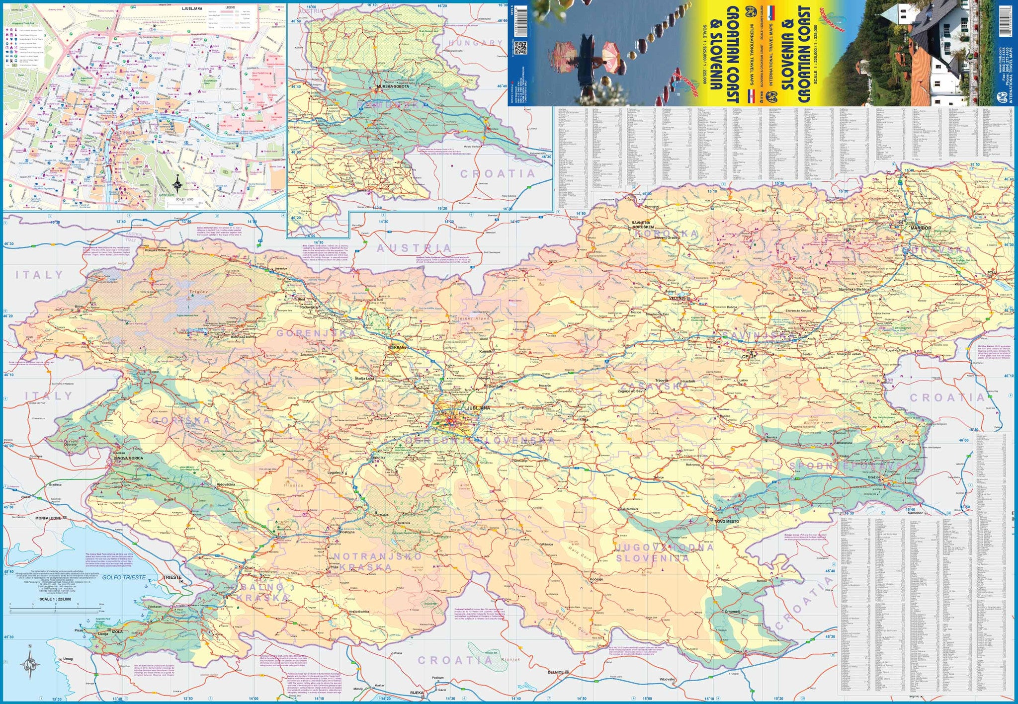
🗺️ Side 1: Slovenia – Compact, Scenic, and Accessible
Slovenia may be small, but it’s full of charm, dramatic alpine scenery, and modern infrastructure. This side of the map covers the entire country in detail, including:
-
Comprehensive road network – Highways, secondary routes, and scenic drives
-
Inset map of Ljubljana – A detailed look at the capital, including key streets, landmarks, and transport hubs
-
Mountain ranges, lakes, and national parks – Including the Julian Alps, Lake Bled, and Triglav National Park
-
Modern travel infrastructure – Well-marked towns, accommodation centres, and tourist icons
With affordable prices, stunning landscapes, and easy access from Austria and Italy, Slovenia continues to grow in popularity among independent travellers and road trippers.
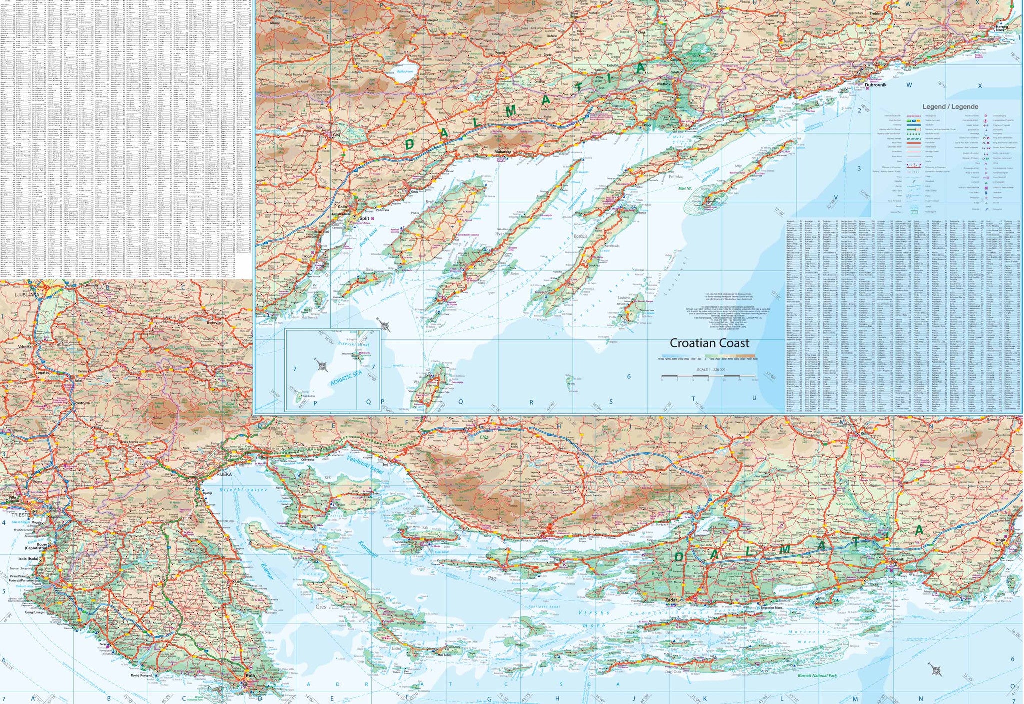
🌊 Side 2: Croatian Coast – The Dalmatian Riviera
The reverse side is dedicated to the stunning Dalmatian Coast of Croatia, one of Europe’s premier travel destinations. Now part of the EU, border crossings from Italy or Slovenia are seamless, and the modern coastal motorway makes for effortless travel all the way down to Dubrovnik.
This map features:
-
The entire Dalmatian coastline, from Pula in the north to Dubrovnik in the south
-
Major Adriatic islands, including Cres, Brač, Hvar, and more
-
Historic coastal towns – Zadar, Šibenik, Split, and Dubrovnik, all shown with fine cartographic detail
-
Motorway updates, including the nearly complete coastal highway and the complex bypass project through Bosnia
-
Ferry routes and ports, helping travellers navigate the popular island-hopping circuits
From UNESCO World Heritage Sites to sun-drenched beaches, this map captures it all in a vibrant and readable format.
📐 Specifications
| Feature | Detail |
|---|---|
| Map Title | Croatian Coast & Slovenia Travel Map |
| Publisher | ITMB (International Travel Maps) |
| Format | Double-sided folded map |
| Map Coverage | Side 1: Slovenia + Ljubljana inset Side 2: Croatian Coast incl. Pula, Split, Dubrovnik, islands |
| Map Size | 686 mm x 991 mm |
| Road Detail | Motorways, secondary roads, ferry lines |
| Points of Interest | Cities, parks, UNESCO sites, ferry ports |
| Paper Type | Travel-grade paper (folded) |
| Language | English |
Perfect For:
-
Self-drive travellers exploring Slovenia and Croatia
-
Adventurers and backpackers hopping between the Adriatic islands
-
Coastal holidaymakers seeking beaches, towns, and local gems
-
Geography students and map enthusiasts looking for a clear, up-to-date reference
-
Travel agencies and tour guides planning itineraries across the Balkans
With its clear layout, high-level detail, and practical format, the Croatian Coast & Slovenia Map by ITMB is the perfect tool for navigating two of Europe’s most scenic and historic regions. Whether you're sipping coffee in Ljubljana or watching the sunset over Hvar, this map ensures you won’t miss a thing.
Plan your journey. Trace your route. Travel with confidence.


