- Australia ▾
- Topographic
▾
- Australia AUSTopo 250k (2025)
- Australia 50k Geoscience maps
- Australia 100k Geoscience maps
- Australia 250k Geoscience maps
- Australia 1:1m Geoscience maps
- New Zealand 50k maps
- New Zealand 250k maps
- New South Wales 25k maps
- New South Wales 50k maps
- New South Wales 100k maps
- Queensland 10k maps
- Queensland 25k maps
- Queensland 50k maps
- Queensland 100k maps
- Western Australia 25k maps
- Western Australia 50k maps
- Western Australia 100k maps
- Compasses
- Software
- GPS Systems
- International ▾
- Wall Maps
▾
- World
- Australia & New Zealand
- Countries, Continents & Regions
- Historical
- Vintage National Geographic
- Australian Capital Territory
- New South Wales
- Northern Territory
- Queensland
- South Australia
- Tasmania
- Victoria
- Western Australia
- Celestial
- Children's
- Mining & Resources
- Wine Maps
- Healthcare
- Postcode Maps
- Electoral Maps
- Nautical ▾
- Flags
▾
- Australian Flag Sets & Banners
- Flag Bunting
- Handwavers
- Australian National Flags
- Aboriginal Flags
- Torres Strait Islander Flags
- International Flags
- Flagpoles & Accessories
- Australian Capital Territory Flags
- New South Wales Flags
- Northern Territory Flags
- Queensland Flags
- South Australia Flags
- Tasmania Flags
- Victoria Flags
- Western Australia Flags
- Gifts ▾
- Globes ▾
Dear valued customer. Please note that our checkout is not supported by old browsers. Please use a recent browser to access all checkout capabilities


Senegal Gambia ITMB Map
$24.95
Afterpay is only available for orders between $50.00 and $1000.00 More info
Double-Sided | Waterproof Lamination Available | First-Hand Cartographic Research
Scale: 1:800,000
Size: 680 mm x 990 mm
ISBN: 9781553413905
Edition: Updated from recent on-the-ground research
🌍 Explore West Africa’s Riverfront Nations – One Map, Two Stories
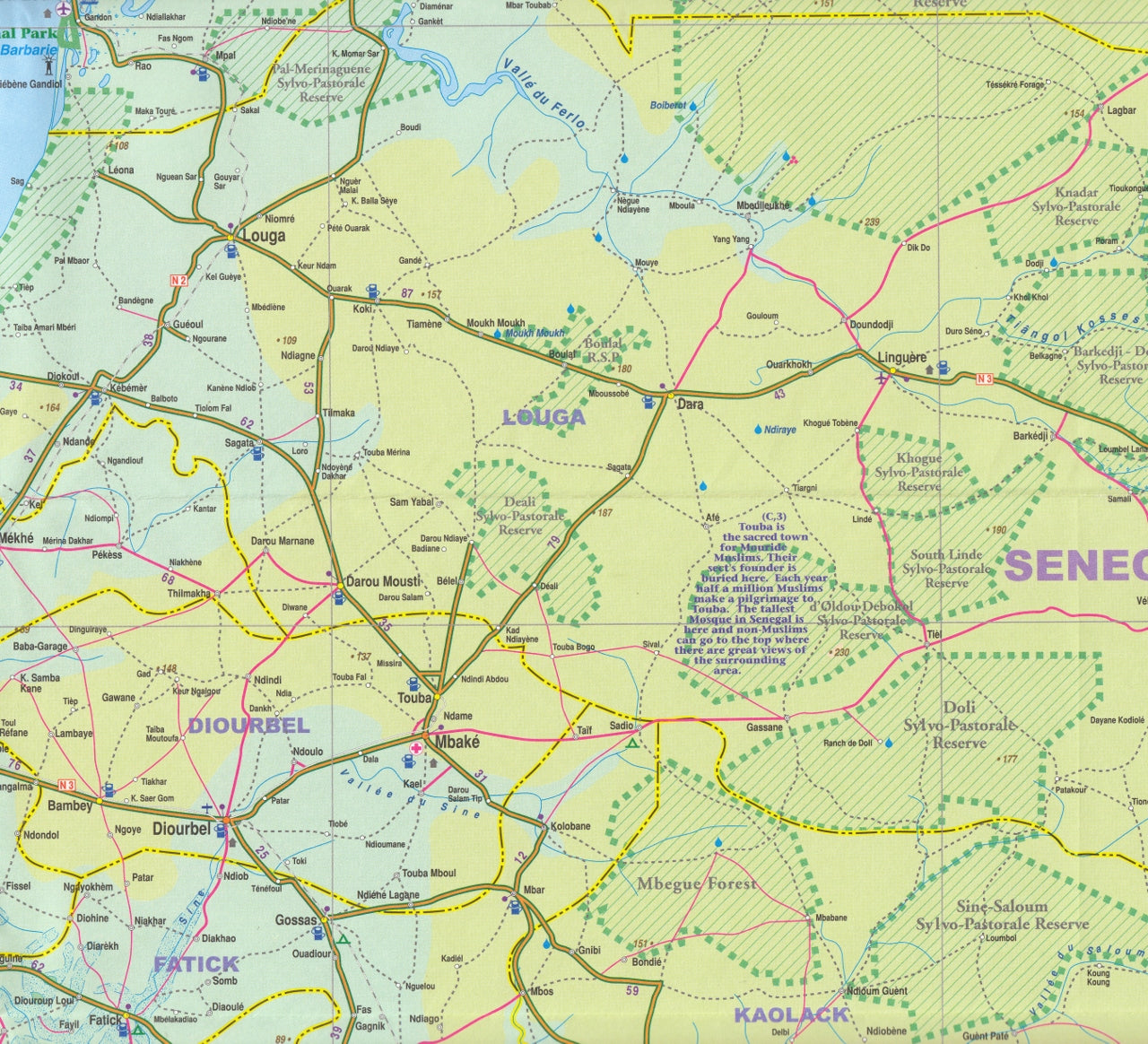
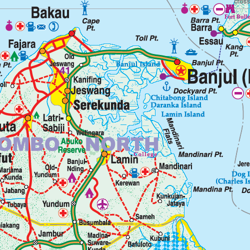
This comprehensive and up-to-date travel map from ITMB covers Senegal and The Gambia on two fully separate, dedicated sides — giving equal cartographic attention to both countries while acknowledging their deep interconnection.
Though politically independent, Senegal and The Gambia share an entwined geography, culture, and infrastructure that make it impractical to explore one without the other. This edition was meticulously updated following an in-person research expedition, improving accuracy and clarity based on the latest travel conditions and road developments.
🧭 Map Features:
🗺️ Double-Sided Format
-
Side 1: Senegal – Full country map with roads, towns, administrative boundaries, and coastal resort areas
-
Side 2: The Gambia – Detailed mapping of The Gambia including roads, checkpoints, tourism zones, and river access
Each side has its own front cover, allowing you to fold and display either country outward for convenient reference.
🚗 Road Networks & Travel Infrastructure
-
Primary and secondary roads, including ongoing paving projects
-
Verified east–west transport routes across both nations
-
Ferry crossings, rural access roads, and border points
-
Locations of coastal resort developments in both countries
🏝️ Tourism & Natural Attractions
-
Coastal highlights including Saly, Cap Skirring, and the Gambia River Estuary
-
Parks, nature reserves, and protected wetlands
-
Cultural towns and historical sites
-
Visitor-friendly beaches and travel hubs
👮 Travel Insight:
-
Police and military checkpoints marked where applicable (especially in The Gambia)
-
Locations with improved road conditions and easier border crossings
-
Real-world travel observations included for planning authenticity
🧷 Optional Lamination for Durability
This map can be laminated on request, making it ideal for frequent travelers, educators, or planners.
-
✅ Draw on it with whiteboard markers
-
✅ Apply removable map dots or stickers
-
✅ Wipe-clean surface for long-term use
-
✅ Protects against moisture, tears, and wear
📌 Laminated versions are flattened and encapsulated in premium 80-micron laminate. Please note: fold lines may still be faintly visible due to the original map format.
📌 At a Glance:
| Feature | Details |
|---|---|
| Map Type | Double-sided folded map |
| Scale | 1:800,000 |
| Size | 680 mm x 990 mm |
| ISBN | 9781553413905 |
| Format Options | Folded paper / Laminated |
| Edition | Field-researched, updated edition |
| Regions Covered | Entirety of Senegal and The Gambia |
🌅 Why Buy This Map?
-
✔️ Up-to-date and field-researched: Based on direct cartographic research by ITMB
-
✔️ Two-in-one practicality: Seamlessly plan a trip that includes both countries
-
✔️ Travel ready: Perfect for overland explorers, aid workers, students, and cultural travelers
-
✔️ Durable option available: Laminate it and take it with you on the road, river, or desert track
Whether you're tracing the historic routes of the Gambia River, exploring Dakar’s dynamic coast, or venturing inland to discover Senegal's national parks, this map offers everything you need to plan, navigate, and experience West Africa’s twin nations with confidence.
Fold it. Mark it. Travel it.
Frequently Asked Questions
Where can I buy the Senegal Gambia ITMB Map?
The Senegal Gambia ITMB Map is available to buy online from Mapworld, Australia's largest map and geographic product retailer, with fast shipping Australia-wide.
Is the Senegal Gambia ITMB Map in stock at Mapworld?
Mapworld maintains extensive stock across its map range and aims for fast dispatch. Orders placed before 2pm AEST on business days are typically dispatched the same day, with standard and express Australia-wide delivery options available.
What is Mapworld's returns policy?
Mapworld accepts returns on undamaged items in original condition. Contact Mapworld within 90 days of purchase to arrange a return or exchange.
Does Mapworld ship the Senegal Gambia ITMB Map across Australia?
Yes, Mapworld ships Australia-wide. Standard shipping is a flat $7 rate, with free standard shipping on orders over $75. Express options are available at checkout. Most orders placed before 2pm AEST on weekdays are dispatched same day.
Related Items


© 2026 Mapworld. Website designed by Genie Media
X