- Australia ▾
- Topographic
▾
- Australia AUSTopo 250k (2025)
- Australia 50k Geoscience maps
- Australia 100k Geoscience maps
- Australia 250k Geoscience maps
- Australia 1:1m Geoscience maps
- New Zealand 50k maps
- New Zealand 250k maps
- New South Wales 25k maps
- New South Wales 50k maps
- New South Wales 100k maps
- Queensland 10k maps
- Queensland 25k maps
- Queensland 50k maps
- Queensland 100k maps
- Compasses
- Software
- GPS Systems
- Orienteering
- International ▾
- Wall Maps
▾
- World
- Australia & New Zealand
- Countries, Continents & Regions
- Historical
- Vintage National Geographic
- Australian Capital Territory
- New South Wales
- Northern Territory
- Queensland
- South Australia
- Tasmania
- Victoria
- Western Australia
- Celestial
- Children's
- Mining & Resources
- Wine Maps
- Healthcare
- Postcode Maps
- Electoral Maps
- Nautical ▾
- Flags
▾
- Australian Flag Sets & Banners
- Flag Bunting
- Handwavers
- Australian National Flags
- Aboriginal Flags
- Torres Strait Islander Flags
- International Flags
- Flagpoles & Accessories
- Australian Capital Territory Flags
- New South Wales Flags
- Northern Territory Flags
- Queensland Flags
- South Australia Flags
- Tasmania Flags
- Victoria Flags
- Western Australia Flags
- Gifts ▾
- Globes ▾
Dear valued customer. Please note that our checkout is not supported by old browsers. Please use a recent browser to access all checkout capabilities
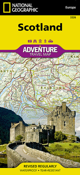
Scotland National Geographic Adventure Map
$27.95
Afterpay is only available for orders between $50.00 and $1000.00 More info
Folded | Waterproof | Tear-Resistant | Adventure-Ready
Scale: 1:440,000
Sheet Size (unfolded): 959 mm x 648 mm
Format: Double-sided, printed on durable synthetic paper
Publisher: National Geographic Maps – Adventure Series
🧭 Discover the Wild Beauty & Cultural Riches of Scotland
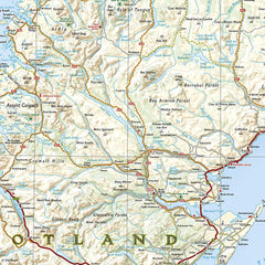
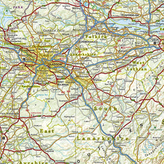
Whether you're chasing the footsteps of ancient clans, hiking the Cairngorm Mountains, following the whisky trail, or planning your next road trip on the North Coast 500, this meticulously designed map brings Scotland’s landscapes to life with National Geographic’s trademark precision and visual clarity.
The Scotland National Geographic Adventure Map is more than a navigation tool—it's a gateway to meaningful exploration, allowing you to connect with the land, its history, and the people who have shaped it. Use it to plan, inspire, and accompany your journey through one of Europe’s most dramatic and storied destinations.
🌍 Coverage Highlights:
🗺️ Full Regional Detail
-
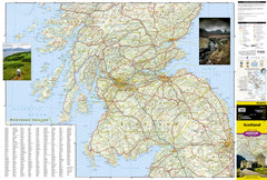
Scotland’s mainland from the southern Lowlands to the rugged Highlands
-
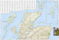
Hebrides including Skye, Lewis, Harris, Barra, and the Inner Isles
-
Northern islands: Includes inset maps for the Orkney and Shetland Islands
-
Lochs, rivers, mountains, and over 100 marked cultural and natural landmarks
🛣️ Road & Travel Infrastructure
-
Major and minor roads, motorways, scenic byways, and unsealed tracks
-
Driving distances clearly marked for route planning
-
Ferry routes to the islands, rail lines, and travel connections
🧭 Tourism & Outdoor Information
-
Hiking and Munro-bagging areas marked
-
National parks such as Cairngorms and Loch Lomond & The Trossachs
-
Sites of historic and cultural interest including:
-
Urquhart Castle on Loch Ness
-
Battlefield sites like Culloden
-
UNESCO sites and ancient stone circles
-
-
Recreational locations including golf courses, climbing areas, and nature reserves
🏙️ Urban and Village Reference
-
Major cities: Edinburgh, Glasgow, Aberdeen, Dundee, Inverness
-
Index of towns and villages for easy reference
-
Clearly labeled regional boundaries
🌦️ Built to Withstand the Highlands – Whatever the Weather
Printed on synthetic, adventure-grade paper, this map is:
-
✅ Waterproof
-
✅ Tear-resistant
-
✅ Foldable and field-ready
Perfect for long-distance hikers, cyclists, campervan travellers, and outdoor adventurers—it folds small, packs light, and survives anything the Scottish skies throw at you.
🎯 Who Is This Map For?
| Traveller Type | Why This Map Works For You |
|---|---|
| 🥾 Hikers & Munro Baggers | Discover routes and elevation features across Scotland’s mountain ranges |
| 🚗 Road Trippers | Plan epic drives like the North Coast 500 with distances and scenic roads marked |
| 🏰 Culture Seekers | Track castles, ruins, battlefields, and heritage towns |
| 🌿 Nature Lovers | Find lochs, national parks, wildlife reserves, and more |
| 📸 Adventure Photographers | Locate remote beauty spots and off-the-grid scenery |
| 🧭 Map Enthusiasts | Appreciate National Geographic’s world-class cartography |
🏆 Why Choose a National Geographic Adventure Map?
-
Legendary cartographic heritage and modern data
-
Designed for explorers: Intuitive, readable, and information-rich
-
Backed by over a century of expedition experience
Whether you’re trekking in Skye, wandering Edinburgh’s Old Town, or planning a photography expedition in Glencoe, this is the map that keeps you oriented, inspired, and immersed in the journey—not just the destination.
📌 Specifications at a Glance:
| Feature | Detail |
|---|---|
| Map Type | Folded, waterproof, synthetic |
| Scale | 1:440,000 |
| Sheet Size | 959 mm x 648 mm (unfolded) |
| Printed On | Tear-resistant synthetic stock |
| Publisher | National Geographic Maps |
| Edition | Adventure Map Series |
Bring Scotland to life—with National Geographic’s most durable and detailed travel companion.
Fold it. Pack it. Explore


