- Australia ▾
- Topographic
▾
- Australia AUSTopo 250k (2025)
- Australia 50k Geoscience maps
- Australia 100k Geoscience maps
- Australia 250k Geoscience maps
- Australia 1:1m Geoscience maps
- New Zealand 50k maps
- New Zealand 250k maps
- New South Wales 25k maps
- New South Wales 50k maps
- New South Wales 100k maps
- Queensland 10k maps
- Queensland 25k maps
- Queensland 50k maps
- Queensland 100k maps
- Western Australia 25k maps
- Western Australia 50k maps
- Western Australia 100k maps
- Compasses
- Software
- GPS Systems
- International ▾
- Wall Maps
▾
- World
- Australia & New Zealand
- Countries, Continents & Regions
- Historical
- Vintage National Geographic
- Australian Capital Territory
- New South Wales
- Northern Territory
- Queensland
- South Australia
- Tasmania
- Victoria
- Western Australia
- Celestial
- Children's
- Mining & Resources
- Wine Maps
- Healthcare
- Postcode Maps
- Electoral Maps
- Nautical ▾
- Flags
▾
- Australian Flag Sets & Banners
- Flag Bunting
- Handwavers
- Australian National Flags
- Aboriginal Flags
- Torres Strait Islander Flags
- International Flags
- Flagpoles & Accessories
- Australian Capital Territory Flags
- New South Wales Flags
- Northern Territory Flags
- Queensland Flags
- South Australia Flags
- Tasmania Flags
- Victoria Flags
- Western Australia Flags
- Gifts ▾
- Globes ▾
Dear valued customer. Please note that our checkout is not supported by old browsers. Please use a recent browser to access all checkout capabilities


Sahara ITMB Travel Map
$24.95
Afterpay is only available for orders between $50.00 and $1000.00 More info
Edition: Latest
Scale: 1:3,850,000
Size: 680 mm x 990 mm
Publisher: ITMB (International Travel Maps)
Format: Folded map (also available laminated – see below)
🏜️ Traverse the Greatest Desert on Earth with Confidence
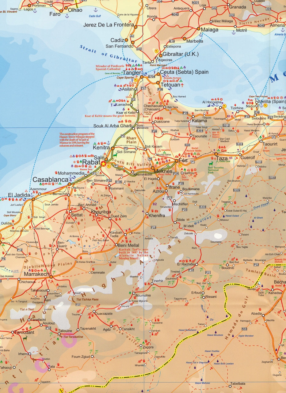
Explore one of the most vast and awe-inspiring landscapes on the planet — the legendary Sahara Desert — with this updated and meticulously detailed map by ITMB. Spanning from the Atlantic shores of Morocco and Mauritania in the west to the Red Sea coastline of Egypt in the east, and stretching deep into Niger, Chad, and Sudan, this travel map captures the immense scale and fascinating topography of northern Africa.
This is not a schematic or stylised view — this is a satellite-derived, GPS-accurate map, built from ITMB’s growing digital cartographic database for Africa. Whether you’re planning an expedition, studying historical trans-Saharan trade routes, or tracing modern passageways through the dunes, this map is an invaluable tool.
🗺️ Coverage Includes:
-
Western Sahara, Morocco, Mauritania
-
Algeria and Libya, with detailed terrain of the Ahaggar Mountains and Fezzan
-
Egypt, including the Nile Delta, Cairo, and desert oases
-
Northern reaches of Mali, Niger, Chad, and Sudan
-
Major overland travel routes including:
-
Western route: Morocco – Mauritania – Senegal
-
Central route: Algeria – Tamanrasset – Nigeria
-
Eastern route: Egypt – Sudan – onwards to Cape Town
-
🧳 Ideal For:
-
Overland adventurers and desert explorers
-
Historical and cultural research
-
Academic and classroom use
-
Travel enthusiasts planning trans-Saharan expeditions
-
Route planners and armchair explorers
📍 Map Features:
-
🧭 Accurate GPS-referenced topography
-
🛣️ Major highways, secondary roads, and desert tracks
-
🏜️ Dune fields, oases, mountain ranges, and salt flats
-
🕌 Key cities and settlements marked, including:
-
Cairo, Tripoli, Nouakchott, Tamanrasset, Khartoum
-
-
📈 Elevation shading and physical relief for desert terrain
-
🗺️ Highlights cross-desert routes used historically and today
-
⚠️ Informative boundaries that illustrate contemporary realities without enforcing political commentary
💧 Optional Laminated Version
We offer a laminated version of this map, ideal for fieldwork or wall display. The lamination process uses true encapsulation with two sheets of 80-micron gloss laminate, making the map:
-
✅ Waterproof
-
✅ Tear-resistant
-
✅ Writable with whiteboard markers
-
✅ Reusable and long-lasting
📌 Note: Fold lines may still be faintly visible through the lamination, as the process involves flattening the folded map for encapsulation.
📦 Format Options
| Format | Features |
|---|---|
| Folded Paper Map | Lightweight, portable, easy to store in travel packs |
| Laminated (Flat) Map | Durable, wipeable, suitable for dry-erase pens |
Explore the vast Sahara like never before — with its timeless caravan trails, dramatic sand seas, and remote cities. Whether you're travelling in person or through the pages of a story, this map brings the desert to life with clarity and scale.
Your journey across the Sahara begins with the right map.
Frequently Asked Questions
Where can I buy the Sahara ITMB Travel Map?
The Sahara ITMB Travel Map is available to buy online from Mapworld, Australia's largest map and geographic product retailer, with fast shipping Australia-wide.
Is the Sahara ITMB Travel Map in stock at Mapworld?
Mapworld maintains extensive stock across its map range and aims for fast dispatch. Orders placed before 2pm AEST on business days are typically dispatched the same day, with standard and express Australia-wide delivery options available.
What is Mapworld's returns policy?
Mapworld accepts returns on undamaged items in original condition. Contact Mapworld within 90 days of purchase to arrange a return or exchange.
Does Mapworld ship the Sahara ITMB Travel Map across Australia?
Yes, Mapworld ships Australia-wide. Standard shipping is a flat $7 rate, with free standard shipping on orders over $75. Express options are available at checkout. Most orders placed before 2pm AEST on weekdays are dispatched same day.
Related Items


© 2026 Mapworld. Website designed by Genie Media
X