- Australia ▾
- Topographic
▾
- Australia AUSTopo 250k (2025)
- Australia 50k Geoscience maps
- Australia 100k Geoscience maps
- Australia 250k Geoscience maps
- Australia 1:1m Geoscience maps
- New Zealand 50k maps
- New Zealand 250k maps
- New South Wales 25k maps
- New South Wales 50k maps
- New South Wales 100k maps
- Queensland 10k maps
- Queensland 25k maps
- Queensland 50k maps
- Queensland 100k maps
- Western Australia 25k maps
- Western Australia 50k maps
- Western Australia 100k maps
- Compasses
- Software
- GPS Systems
- International ▾
- Wall Maps
▾
- World
- Australia & New Zealand
- Countries, Continents & Regions
- Historical
- Vintage National Geographic
- Australian Capital Territory
- New South Wales
- Northern Territory
- Queensland
- South Australia
- Tasmania
- Victoria
- Western Australia
- Celestial
- Children's
- Mining & Resources
- Wine Maps
- Healthcare
- Postcode Maps
- Electoral Maps
- Nautical ▾
- Flags
▾
- Australian Flag Sets & Banners
- Flag Bunting
- Handwavers
- Australian National Flags
- Aboriginal Flags
- Torres Strait Islander Flags
- International Flags
- Flagpoles & Accessories
- Australian Capital Territory Flags
- New South Wales Flags
- Northern Territory Flags
- Queensland Flags
- South Australia Flags
- Tasmania Flags
- Victoria Flags
- Western Australia Flags
- Gifts ▾
- Globes ▾
Dear valued customer. Please note that our checkout is not supported by old browsers. Please use a recent browser to access all checkout capabilities


Russia ITMB Map
$24.95
Afterpay is only available for orders between $50.00 and $1000.00 More info
Scale: 1:6,000,000 | Double-Sided | Folded or Laminated
Traverse the Largest Country on Earth
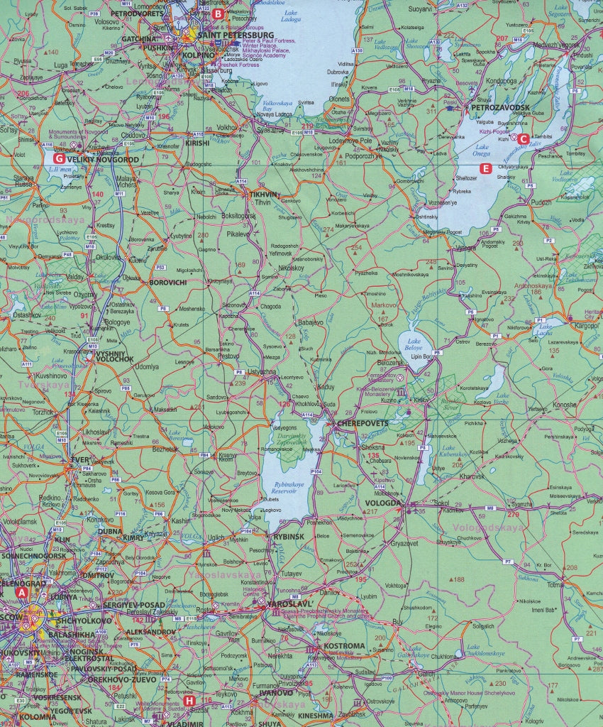
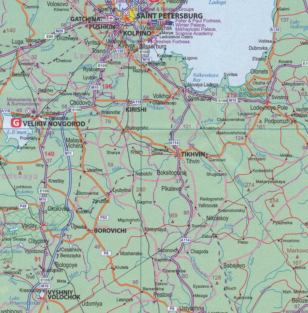
Spanning eleven time zones and two continents, Russia defies the limits of the average map. That’s why this International Travel Maps (ITMB) edition has been thoughtfully designed across two detailed sides, offering an accessible, easy-to-use reference for the world’s largest country.
The Western side of the map focuses on European Russia, covering the area west of the Ural Mountains. This is the heart of the country—home to the bulk of the population and Russia’s major urban and cultural centres including Moscow, St. Petersburg, Nizhny Novgorod, and Kazan. The scale here allows for greater detail, capturing a dense network of roads, railways, and smaller cities that other maps often miss.
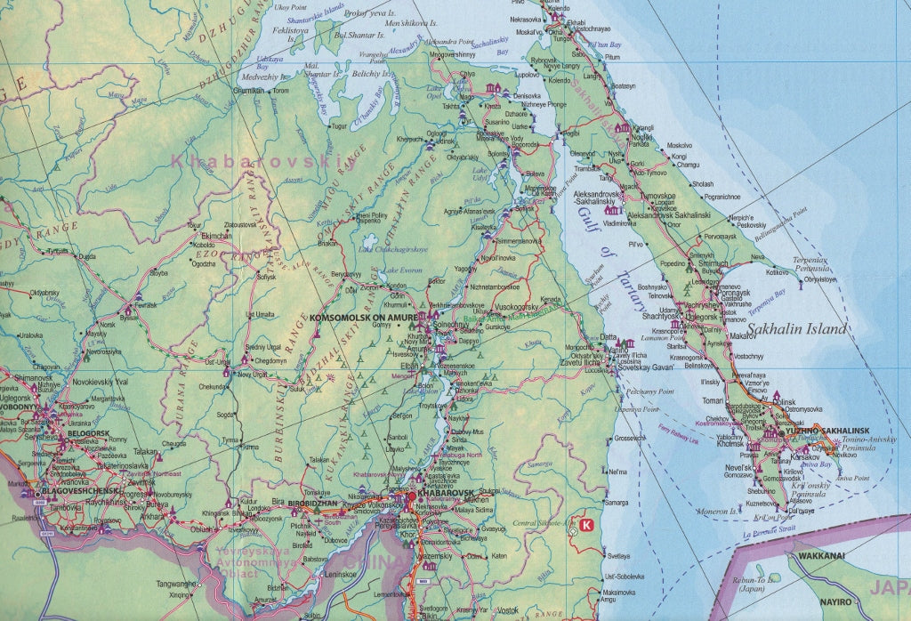
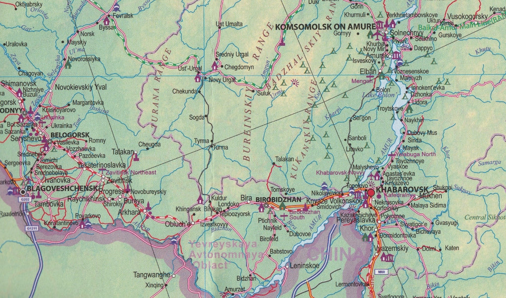
Flip the map, and you’re transported into the vastness of Siberia and the Russian Far East—an enormous sweep of taiga, steppe, and rugged terrain stretching all the way to Vladivostok. This side of the map follows the legendary Trans-Siberian Railway, making it a vital resource for anyone planning one of the world's great train journeys—or simply wanting to understand the sheer geographic scale of this enigmatic nation.
🔍 Key Features
-
Two-Sided Coverage – West Russia on one side (at a more detailed scale), and East Russia/Siberia on the other
-
Clear Road & Rail Networks – Ideal for overland travel, logistics planning, or educational reference
-
Cities & Borders – Includes national and regional borders, cities, towns, rail stops, and road distances
-
Inset Details – Includes key points along the Trans-Siberian Railway, with broader regional context
-
Natural Features – Forests, rivers, lakes, and mountain ranges marked clearly
-
Up-to-Date Cartography – Reflects recent infrastructure developments and geopolitical boundaries
🧭 Map Specifications
| Feature | Detail |
|---|---|
| Scale | 1:6,000,000 |
| Format | Double-sided, folded or laminated |
| Coverage | Full country: West Russia + Siberia & Far East |
| Size (unfolded) | 690 mm (w) x 1000 mm (h) |
| Publisher | International Travel Maps (ITMB) |
🛡️ Laminated Option Available
For durability and versatility, we offer this map fully laminated using high-quality 80-micron gloss encapsulation. This protects against tears, spills, and stains—perfect for frequent use in classrooms, offices, travel planning, or fieldwork.
You can also write on the laminated version with whiteboard markers or apply removable map dots to highlight locations of interest.
Note: Laminated maps are produced by flattening the original folded edition and encapsulating it. Slight crease lines may be visible but do not affect readability.
🚆 Ideal For:
✔️ Trans-Siberian Railway travel planning
✔️ Overland route mapping
✔️ Education and research
✔️ Geography and history enthusiasts
✔️ Business logistics or trade reference
Bold, vast, and surprisingly practical—this ITMB map of Russia turns a geographical giant into a comprehensible and beautifully presented journey.
Frequently Asked Questions
Where can I buy the Russia ITMB Map?
The Russia ITMB Map is available to buy online from Mapworld, Australia's largest map and geographic product retailer, with fast shipping Australia-wide.
Is the Russia ITMB Map in stock at Mapworld?
Mapworld maintains extensive stock across its map range and aims for fast dispatch. Orders placed before 2pm AEST on business days are typically dispatched the same day, with standard and express Australia-wide delivery options available.
What is Mapworld's returns policy?
Mapworld accepts returns on undamaged items in original condition. Contact Mapworld within 90 days of purchase to arrange a return or exchange.
Does Mapworld ship the Russia ITMB Map across Australia?
Yes, Mapworld ships Australia-wide. Standard shipping is a flat $7 rate, with free standard shipping on orders over $75. Express options are available at checkout. Most orders placed before 2pm AEST on weekdays are dispatched same day.
Related Items


© 2026 Mapworld. Website designed by Genie Media
X