- Australia ▾
- Topographic
▾
- Australia AUSTopo 250k (2024)
- Australia 50k Geoscience maps
- Australia 100k Geoscience maps
- Australia 250k Geoscience maps
- Australia 1.1m Geoscience maps
- New Zealand 50k maps
- New Zealand 250k maps
- New South Wales 25k maps
- New South Wales 50k maps
- New South Wales 100k maps
- Queensland 10k maps
- Queensland 25k maps
- Queensland 50k maps
- Queensland 100k maps
- Compasses
- Software
- GPS Systems
- Orienteering
- International ▾
- Wall Maps
▾
- World
- Australia & New Zealand
- Countries, Continents & Regions
- Historical
- Vintage National Geographic
- Australian Capital Territory
- New South Wales
- Northern Territory
- Queensland
- South Australia
- Tasmania
- Victoria
- Western Australia
- Celestial
- Children's
- Mining & Resources
- Wine Maps
- Healthcare
- Postcode Maps
- Electoral Maps
- Nautical ▾
- Flags
▾
- Australian Flag Sets & Banners
- Flag Bunting
- Handwavers
- Australian National Flags
- Aboriginal Flags
- Torres Strait Islander Flags
- International Flags
- Flagpoles & Accessories
- Australian Capital Territory Flags
- New South Wales Flags
- Northern Territory Flags
- Queensland Flags
- South Australia Flags
- Tasmania Flags
- Victoria Flags
- Western Australia Flags
- Gifts ▾
- Globes ▾
Dear valued customer. Please note that our checkout is not supported by old browsers. Please use a recent browser to access all checkout capabilities
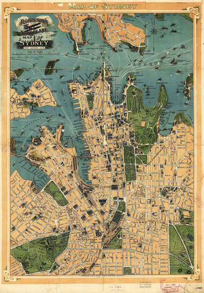
Robinson's Aeroplane Wall Map of Sydney (Port Jackson) published 1922
$69.95
or make 4 interest-free payments of
$17.49 AUD
fortnightly with
![]() More info
More info
A soaring perspective of Sydney's harbour city from the golden age of aviation cartography.
Step back in time and witness Sydney from above, just as the burgeoning aviation age was beginning to transform the way we viewed the world. Originally published in 1927 by H.E.C. Robinson—a cornerstone of Australian cartographic history—this breathtaking Aeroplane Map of Sydney (Port Jackson) presents a bird's-eye view of the city in rich sepia tones and oceanic blues. It captures a moment of quiet elegance between the wars, when steam ferries plied the waters of the harbour and the skyline was a tapestry of domes, spires, and sandstone facades.
Unlike standard maps, this piece is a visual celebration: ferries are shown in motion on their routes, and landmark buildings of the day are meticulously illustrated in three-dimensional detail. The Opera House is still decades away, and the Harbour Bridge not yet built—making this map an evocative portrait of a city still finding its modern identity. Circular Quay, Government House, and the intricate shoreline of Port Jackson are all rendered with care and precision, making this not only a useful map, but a remarkable window into the past.
🗺️ Map Options
This archival-quality reproduction is available in three premium finishes to suit your space and style:
• Paper Print (160gsm heavyweight stock):
Ideal for framing under glass. Crisp, colourfast, and perfect for traditional displays.
• Laminated (Encapsulated in 80-micron gloss laminate):
Tear-resistant, waterproof, and dry-erase friendly. Excellent for educational, office, or display use where durability is key.
• Canvas (395gsm HP Professional Matte Canvas):
Our highest-quality finish. Printed using pigment-based inks for vibrant detail and fade resistance. Can be ordered with optional wooden hang rails—lacquered in natural timber and strung with a hanging cord—for a timeless gallery feel.
🪵 Please allow up to 10 working days for delivery of hang-railed canvas maps, as each one is custom-mounted by our framer.
📐 Sizes Available
| Format | Width (mm) | Height (mm) |
|---|---|---|
| Large | 600 | 850 |
| Supermap | 930 | 1300 |
📚 Historical Background
H.E.C. Robinson was Australia’s most prolific map publisher of the early 20th century. Based in Sydney, the company produced countless street directories, wall maps, and pictorial guides. This Aeroplane Map—created in an era when flight was still novel and aerial perspectives a luxury—is a rare example of an early "skyward" rendering, made well before satellites and drones would become common tools of mapmakers. It blends the romanticism of early aviation with the craftsmanship of traditional cartography.
Whether you’re a local history enthusiast, a cartophile, or someone who simply loves the aesthetic charm of vintage maps, this piece is a conversation starter and a collector’s treasure.
Made in Australia
A faithful, premium reproduction of a historical Australian original—printed, finished, and framed on Australian soil.


