- Australia ▾
- Topographic
▾
- Australia AUSTopo 250k (2024)
- Australia 50k Geoscience maps
- Australia 100k Geoscience maps
- Australia 250k Geoscience maps
- Australia 1.1m Geoscience maps
- New Zealand 50k maps
- New Zealand 250k maps
- New South Wales 25k maps
- New South Wales 50k maps
- New South Wales 100k maps
- Queensland 10k maps
- Queensland 25k maps
- Queensland 50k maps
- Queensland 100k maps
- Compasses
- Software
- GPS Systems
- Orienteering
- International ▾
- Wall Maps
▾
- World
- Australia & New Zealand
- Countries, Continents & Regions
- Historical
- Vintage National Geographic
- Australian Capital Territory
- New South Wales
- Northern Territory
- Queensland
- South Australia
- Tasmania
- Victoria
- Western Australia
- Celestial
- Children's
- Mining & Resources
- Wine Maps
- Healthcare
- Postcode Maps
- Electoral Maps
- Nautical ▾
- Flags
▾
- Australian Flag Sets & Banners
- Flag Bunting
- Handwavers
- Australian National Flags
- Aboriginal Flags
- Torres Strait Islander Flags
- International Flags
- Flagpoles & Accessories
- Australian Capital Territory Flags
- New South Wales Flags
- Northern Territory Flags
- Queensland Flags
- South Australia Flags
- Tasmania Flags
- Victoria Flags
- Western Australia Flags
- Gifts ▾
- Globes ▾
Dear valued customer. Please note that our checkout is not supported by old browsers. Please use a recent browser to access all checkout capabilities


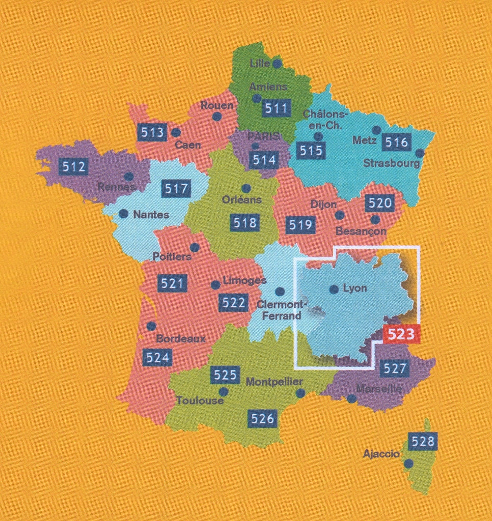
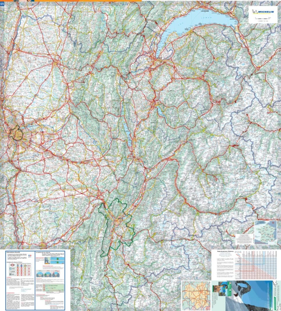
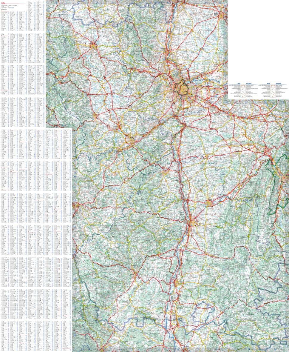
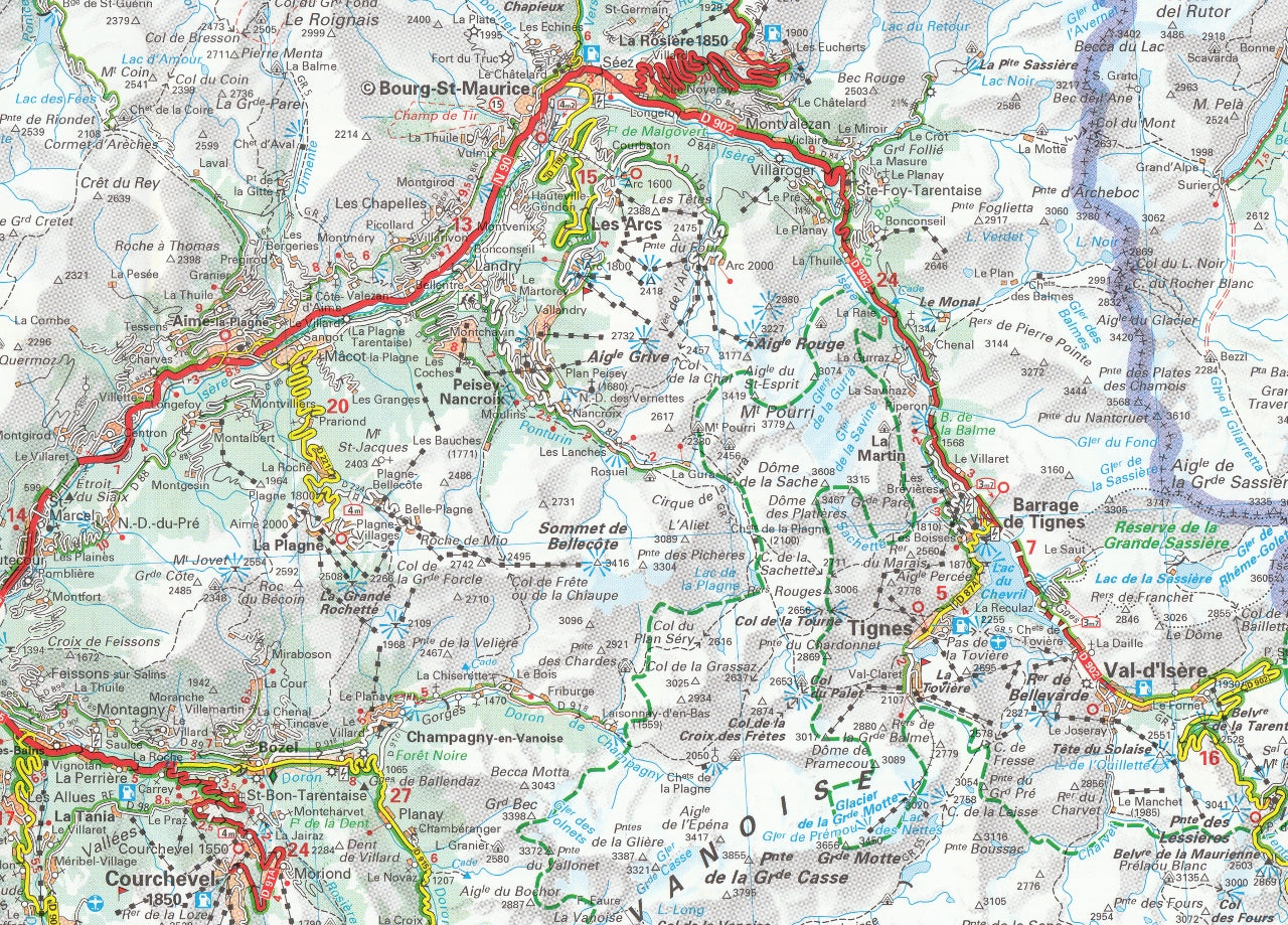
France Rhone-Alps 523 Michelin Map
$21.95
Afterpay is only available for orders between $50.00 and $1000.00 More info
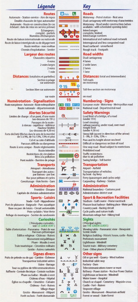
Scale: 1:200,000 | Size: 1200 mm x 1000 mm | Multilingual Key Included
Explore the Heart of the French Alps with Michelin’s Trusted Cartography
Experience the dramatic beauty, world-renowned roads, and cultural richness of southeastern France with the Michelin Rhone-Alps Regional Map 523. Designed for precision and usability, this detailed map is an essential travel companion for anyone journeying through the Rhone Valley, the French Alps, and surrounding areas.
With Michelin’s signature cartographic quality, this map delivers unparalleled accuracy and clarity, ideal for both route planning and on-the-road navigation.
✅ Key Features & Benefits
🗺️ Comprehensive Road Coverage
At a detailed 1:200,000 scale, this map features:
-
Motorways (including those under construction)
-
National, regional, and scenic roads
-
Road numbers and kilometre distances
-
International boundaries clearly marked
🏞️ Perfect for Touring and Exploration
This region includes some of France’s most iconic routes and destinations:
-
Lyon, Grenoble, Annecy, Chambéry, Chamonix, and Valence
-
Access to the French Alps, Mont Blanc, and the Route des Grandes Alpes
📌 Local Language Mapping
All place names appear exactly as seen on local French road signs, ensuring consistency with on-the-ground navigation. A multilingual legend, including English, is included for easy interpretation.
📘 Helpful Indexes and Travel Tools
-
Index of principal place names for quick reference
-
Distance and driving time charts to plan your journey efficiently
-
Major town plans for select urban centres, ideal for entry and exit routes
🌍 Michelin Quality You Can Trust
Created by one of Europe’s most respected cartographers, Michelin maps are known for:
-
Clear and readable design
-
Precise scale and landmark accuracy
-
Durable, foldable construction perfect for travel
Product Specifications
| Feature | Description |
|---|---|
| Map Title | Rhone-Alps Regional Map 523 – France |
| Publisher | Michelin |
| Scale | 1:200,000 |
| Size (Unfolded) | 1200 mm x 1000 mm |
| Language | Place names in French; multilingual map key including English |
| Regions Covered | Rhone Valley & French Alps |
| Includes | Major town plans, scenic roads, driving times, tourist information |
🚗 Perfect For:
✔️ Road Trippers & Touring Enthusiasts – Navigate the most scenic and alpine routes in France
✔️ Cyclists & Motorcyclists – Ideal for plotting epic mountain rides
✔️ Travel Planners & Tour Operators – A valuable planning tool for custom itineraries
✔️ Francophiles & Map Collectors – A must-have addition to any collection of French regional maps
✔️ Holidaymakers – Discover hidden villages, lakes, and châteaux throughout the region
Whether you're winding your way through the vineyards of the Rhône Valley, climbing the switchbacks of the Col du Galibier, or exploring the towns that dot the French Alps, this map is your go-to guide for precision and adventure. Trust Michelin to guide you safely and stylishly through one of France’s most beloved regions.
🛒 Add to Cart Today and explore the Rhone-Alps with Michelin's gold-standard regional map at your fingertips.


