- Australia ▾
- Topographic
▾
- Australia AUSTopo 250k (2025)
- Australia 50k Geoscience maps
- Australia 100k Geoscience maps
- Australia 250k Geoscience maps
- Australia 1:1m Geoscience maps
- New Zealand 50k maps
- New Zealand 250k maps
- New South Wales 25k maps
- New South Wales 50k maps
- New South Wales 100k maps
- Queensland 10k maps
- Queensland 25k maps
- Queensland 50k maps
- Queensland 100k maps
- Western Australia 25k maps
- Western Australia 50k maps
- Western Australia 100k maps
- Compasses
- Software
- GPS Systems
- International ▾
- Wall Maps
▾
- World
- Australia & New Zealand
- Countries, Continents & Regions
- Historical
- Vintage National Geographic
- Australian Capital Territory
- New South Wales
- Northern Territory
- Queensland
- South Australia
- Tasmania
- Victoria
- Western Australia
- Celestial
- Children's
- Mining & Resources
- Wine Maps
- Healthcare
- Postcode Maps
- Electoral Maps
- Nautical ▾
- Flags
▾
- Australian Flag Sets & Banners
- Flag Bunting
- Handwavers
- Australian National Flags
- Aboriginal Flags
- Torres Strait Islander Flags
- International Flags
- Flagpoles & Accessories
- Australian Capital Territory Flags
- New South Wales Flags
- Northern Territory Flags
- Queensland Flags
- South Australia Flags
- Tasmania Flags
- Victoria Flags
- Western Australia Flags
- Gifts ▾
- Globes ▾
Dear valued customer. Please note that our checkout is not supported by old browsers. Please use a recent browser to access all checkout capabilities


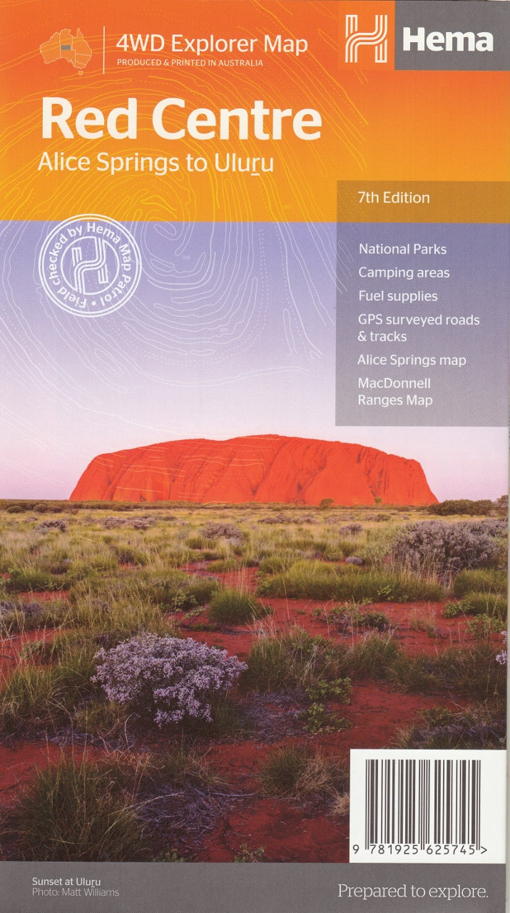
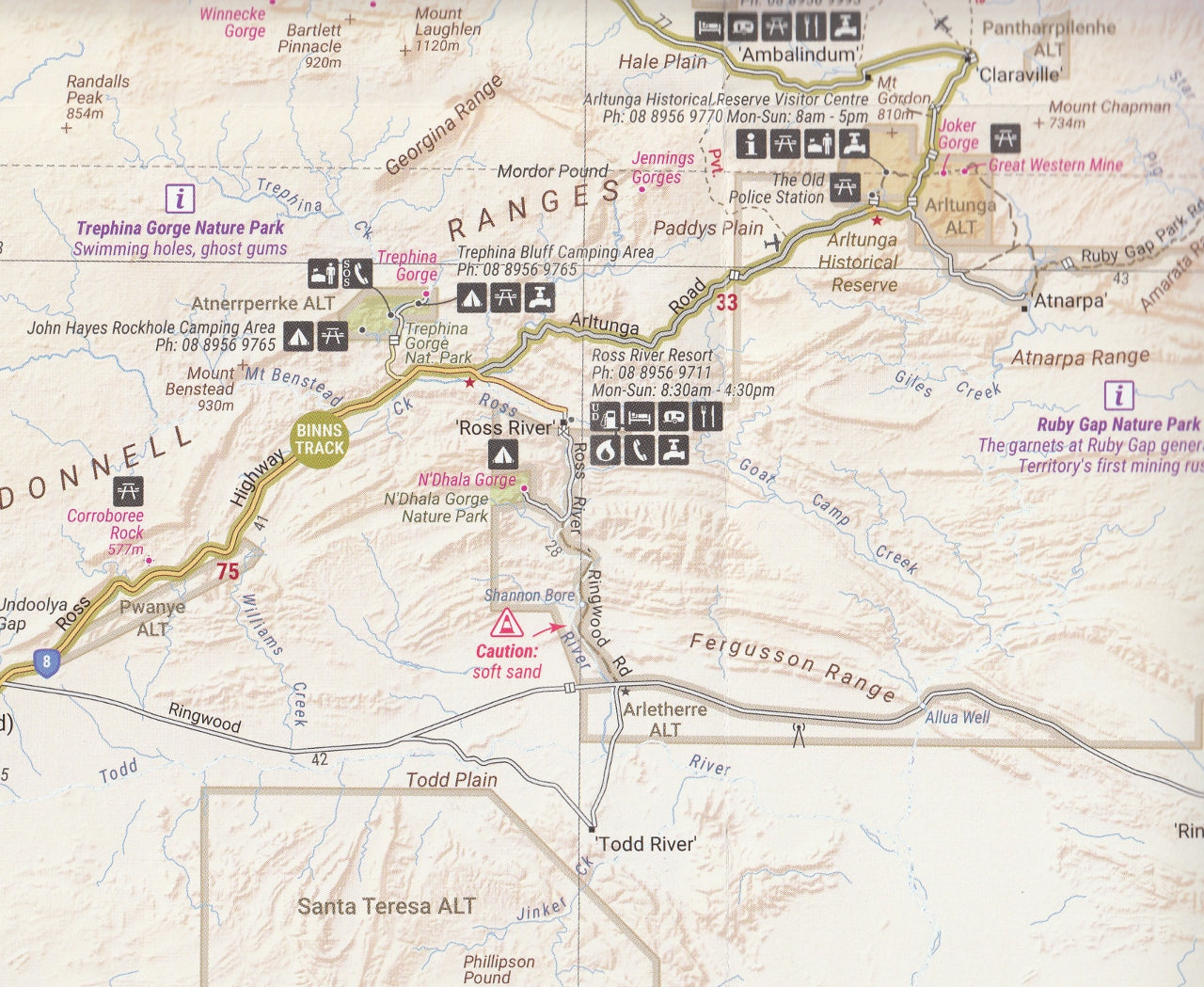
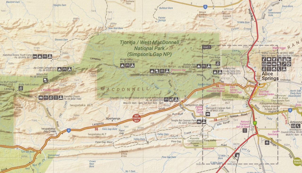
Red Centre Map – Hema Maps (7th Edition)
$14.95 $15.95
Afterpay is only available for orders between $50.00 and $1000.00 More info
A detailed and durable travel map covering Central Australia’s most iconic outback region – perfect for explorers, campers, and 4WD adventurers.
The Hema Red Centre Map (7th Edition) is your essential guide to navigating one of Australia’s most spectacular and culturally significant regions. Stretching across the heart of the Northern Territory, the “Red Centre” is famed for its dramatic desert landscapes, remote outback roads, Aboriginal heritage, and unforgettable natural landmarks such as Uluru (Ayers Rock), Kata Tjuta (The Olgas), Kings Canyon, and the MacDonnell Ranges.
Designed with accuracy and resilience in mind, this map combines the field-verified reliability of the Hema Map Patrol with practical design and exceptional durability. Whether you’re heading out for a day walk, a multi-day 4WD expedition, or a once-in-a-lifetime trip to Uluru, this map will help you get there—and back—safely and informed.
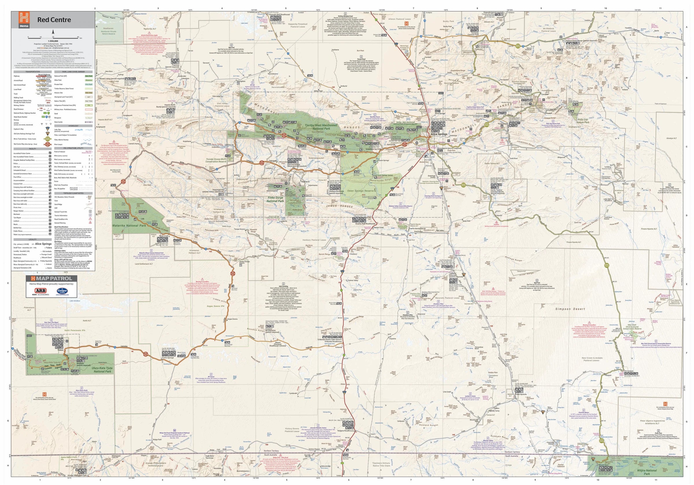
🗺️ Area Coverage
The Red Centre Map includes detailed coverage of the key travel corridors and destinations in Central Australia, such as:
-
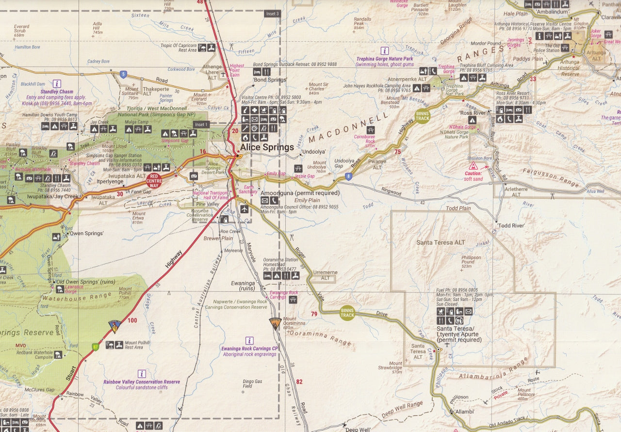
Alice Springs and surrounding suburbs
-
Uluru–Kata Tjuta National Park
-
Kings Canyon & Watarrka National Park
-
West MacDonnell Ranges, including Ormiston Gorge, Glen Helen, Simpsons Gap
-
Finke Gorge & Palm Valley
-
Yulara township, visitor hubs and campgrounds
-
Erldunda, Mt Ebenezer, Hermannsburg, and more
-
Popular tracks and trails such as the Mereenie Loop, Larapinta Trail, and Luritja Road
Whether travelling via the Stuart Highway, exploring off-grid tracks, or connecting to the Great Central Road or Plenty Highway, this map provides the navigation confidence you need.
🧭 Map Features
-
Scale: 1:550,000 – excellent balance between overview and road-level detail
-
Waterproof & Tear-Resistant: Built for tough outback conditions
-
GPS-surveyed roads & tracks: Verified by Hema's Map Patrol for accuracy
-
Sealed and unsealed roads, 4WD-only tracks, and permit-only routes clearly marked
-
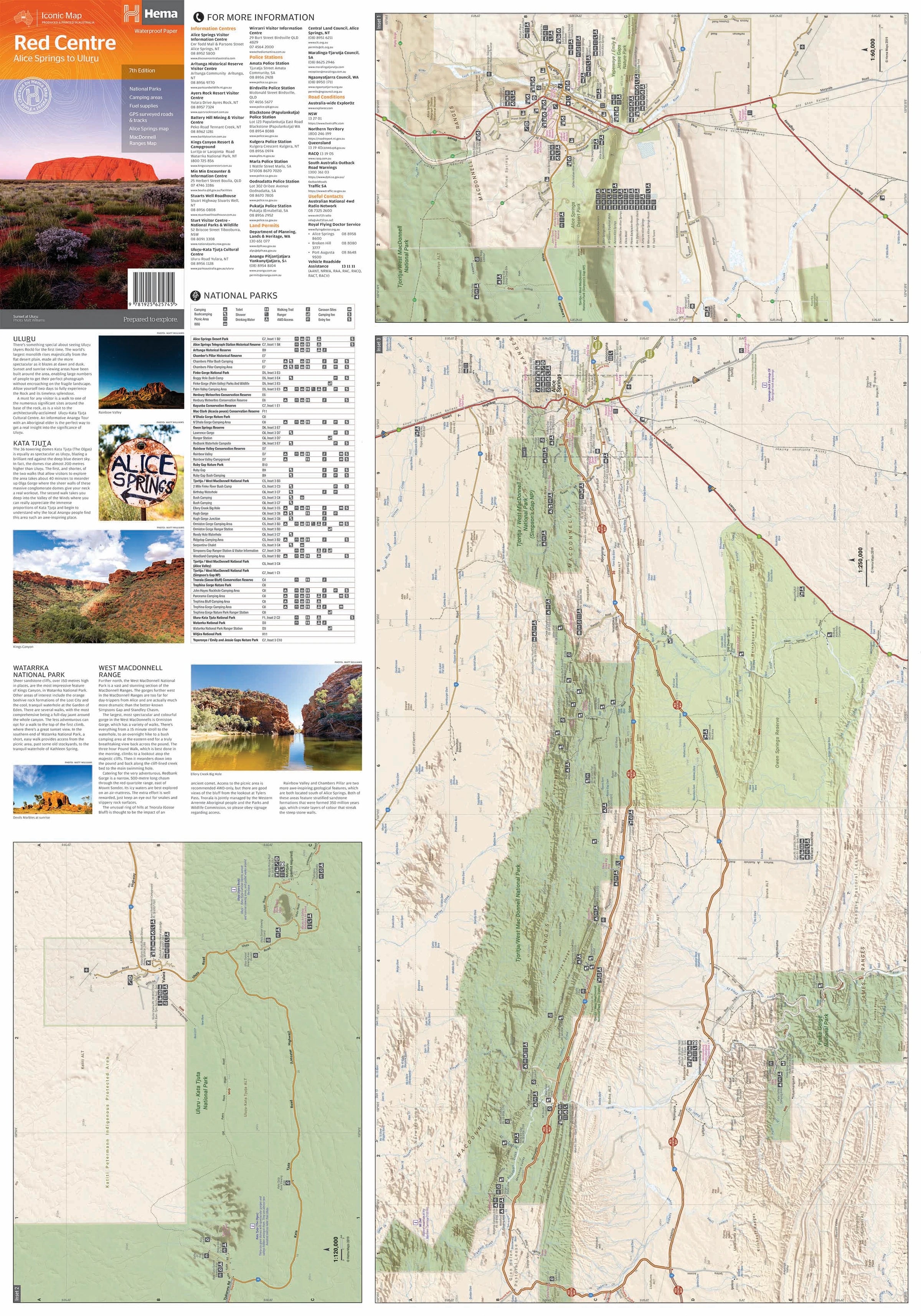
Inset Maps: Includes detailed mapping of:
-
Alice Springs
-
Uluru and Kata Tjuta
-
Yulara township
-
Kings Canyon
-
-
Tourist Information:
-
Fuel stops and roadhouses
-
Designated camping areas and bush camps
-
Walking trails and scenic lookouts
-
Aboriginal lands and access notes
-
Permit requirements and contact details for land councils and visitor centres
-
Distances between key waypoints and travel time estimates
-
-
Terrain Shading & Elevation Markings: Visual topography helps understand elevation changes and landscape features
-
Symbols & Legend:
-
National Parks, historical sites, picnic areas, 4WD access, information centres, and more
-
Facilities such as toilets, showers, campsites, fuel, and water supplies
-
📐 Specifications
-
Edition: 7th
-
Publication Date: April 2019
-
Folded Size: 140 mm x 250 mm
-
Flat Size: 700 mm x 1000 mm
-
Weight: Approx. 90 grams
-
Material: Waterproof and tear-resistant synthetic paper
-
Published by: Hema Maps
-
Printed in: Australia
🎯 Ideal For
-
4WD Enthusiasts: Planning rugged tracks such as the Mereenie Loop or Finke Gorge
-
Caravanners and campers: Locating fuel stops, rest areas, and bush campgrounds
-
Independent travellers: Touring Uluru, Kata Tjuta, and Alice Springs without relying solely on digital navigation
-
Bushwalkers: Identifying access points and route planning along the Larapinta Trail or Kings Canyon Rim Walk
-
Cultural explorers: Learning about Aboriginal communities and respecting access protocols
-
Educators, guides, and students: Teaching or researching the natural and cultural geography of Central Australia
🧭 Why Choose the Hema Red Centre Map?
Hema’s Red Centre Map combines field-tested reliability with practical insight. Trusted by thousands of adventurers, it remains the most respected map available for travel in the heart of the Northern Territory. Its blend of durability, detail, and cultural awareness makes it indispensable for safe and informed travel.
Explore the heart of Australia with confidence.
From the red sand dunes and sacred rock formations to remote tracks and desert oases, the Hema Red Centre Map (7th Edition) is your ultimate guide to one of the world’s most breathtaking outback regions.
Get it. Pack it. Trust it.
The outback is waiting.
This map is also available as a laminated map encapsulated in high-quality plastic.
Frequently Asked Questions
What does the Red Centre Map – Hema Maps (7th Edition) cover?
The Red Centre Map – Hema Maps (7th Edition) covers 4WD tracks, camping areas, and travel routes for the region described in the product title. Most 4WD and camping guides in Mapworld's range include GPS coordinates, distance information, difficulty ratings, and notes on fuel stops and emergency contact points.
Is the Red Centre Map – Hema Maps (7th Edition) up to date?
Yes, this is the current edition. Mapworld stocks current editions from publishers including Hema Maps, Westprint, and others.
Is this product suitable for remote area travel?
Yes, 4WD maps and guides are designed for remote area navigation and trip planning. They include track conditions, fuel availability, camping spots, and safety information.
Does Mapworld ship the Red Centre Map – Hema Maps (7th Edition) across Australia?
Yes, Mapworld ships Australia-wide. Standard shipping is a flat $7 rate, with free standard shipping on orders over $75. Express options are available at checkout. Most orders placed before 2pm AEST on weekdays are dispatched same day.
Related Items


© 2026 Mapworld. Website designed by Genie Media
X