- Australia ▾
- Topographic
▾
- Australia AUSTopo 250k (2024)
- Australia 50k Geoscience maps
- Australia 100k Geoscience maps
- Australia 250k Geoscience maps
- Australia 1.1m Geoscience maps
- New Zealand 50k maps
- New Zealand 250k maps
- New South Wales 25k maps
- New South Wales 50k maps
- New South Wales 100k maps
- Queensland 10k maps
- Queensland 25k maps
- Queensland 50k maps
- Queensland 100k maps
- Compasses
- Software
- GPS Systems
- Orienteering
- International ▾
- Wall Maps
▾
- World
- Australia & New Zealand
- Countries, Continents & Regions
- Historical
- Vintage National Geographic
- Australian Capital Territory
- New South Wales
- Northern Territory
- Queensland
- South Australia
- Tasmania
- Victoria
- Western Australia
- Celestial
- Children's
- Mining & Resources
- Wine Maps
- Healthcare
- Postcode Maps
- Electoral Maps
- Nautical ▾
- Flags
▾
- Australian Flag Sets & Banners
- Flag Bunting
- Handwavers
- Australian National Flags
- Aboriginal Flags
- Torres Strait Islander Flags
- International Flags
- Flagpoles & Accessories
- Australian Capital Territory Flags
- New South Wales Flags
- Northern Territory Flags
- Queensland Flags
- South Australia Flags
- Tasmania Flags
- Victoria Flags
- Western Australia Flags
- Gifts ▾
- Globes ▾
Dear valued customer. Please note that our checkout is not supported by old browsers. Please use a recent browser to access all checkout capabilities
Red Centre Hema 835 x 500mm Laminated Wall Map
$45.00
Afterpay is only available for orders between $50.00 and $1000.00 More info
Your Essential Guide to Australia’s Outback Heart
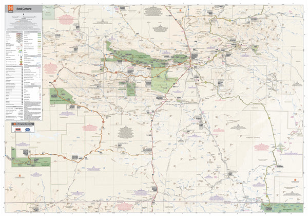
Discover the vast, untamed heart of Australia with the Red Centre Laminated Wall Map by Hema. Meticulously designed and GPS-surveyed, this detailed map covers one of Australia’s most iconic regions—home to rugged ranges, desert tracks, and ancient landmarks. Whether you're planning a once-in-a-lifetime adventure, tracking your journey, or decorating your wall with a piece of the outback, this map offers clarity, detail, and durability in one impressive package.
🗺️ Comprehensive Outback Detail
-
All Roads & Tracks Shown: Clearly outlines sealed and unsealed roads, 4WD tracks, and permit-only routes, helping you navigate confidently through remote country.
-
Essential Travel Services Marked: Fuel supplies, emergency services, campsites, accommodation, and local attractions are all pinpointed for easy planning.
-
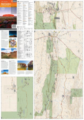
Inset Maps & Rich Photography: Includes detailed insets of Uluru, Kata Tjuta, and Alice Springs, plus stunning photographs that capture the region’s dramatic landscapes.
-
Travel Tips Included: Notes on road conditions, best travel seasons, and important safety tips make this a practical tool for any outback expedition.
📏 Specifications
| Attribute | Details |
|---|---|
| Scale | 1:750,000 – ideal for seeing both the big picture and finer detail of routes, tracks, and landmarks |
| Size | 835 mm (W) x 500 mm (H) – a practical size for pinning up on the wall, using on tables, or storing with your travel gear |
| Material | Laminated (80-micron gloss) – durable, wipeable, and ready for adventure |
| Publisher | Hema Maps – Australia’s most trusted mapping authority |
| Made In | Australia |
Durability & Versatility
Encapsulated in high-quality 80-micron laminate, this map is:
-
Writeable & Wipeable: Use whiteboard markers to plot routes, highlight key stops, or track your journey without permanently marking the map.
-
Resistant to Wear & Tear: Protects against stains, dust, and moisture, ensuring it remains in excellent condition for years.
-
Reusable & Interactive: Ideal for trip planning sessions, travel agencies, classrooms, or personal adventure walls.
⚠️ Please note: This map is laminated from a folded version, so slight fold lines may still be visible after lamination.
Why Choose This Map?
| Feature | Benefit |
|---|---|
| GPS-surveyed detail | Provides reliable, up-to-date information you can trust |
| Inset maps & photos | Adds rich context and extra travel inspiration |
| Highlighting essential services | Ensures safer, more informed journeys |
| Ideal scale & size | Perfect balance between detailed information and ease of use |
| Durable lamination | Built for the rigours of travel or display |
🎯 Perfect For
-
4WD enthusiasts & overlanders preparing expeditions through the Red Centre
-
Campers, caravaners & adventure seekers looking for campsites, fuel stops, and track conditions
-
Tour operators & educators who need a practical, visual reference of Australia’s outback heart
-
Gifts for anyone with a passion for Australia’s rugged, red landscape
Explore, plan, and dream with the Red Centre Laminated Wall Map by Hema—a trusted companion into the beating heart of Australia’s outback.


