

Published by the Division of National Mapping
Map Size: 996 mm (W) x 846 mm (H)
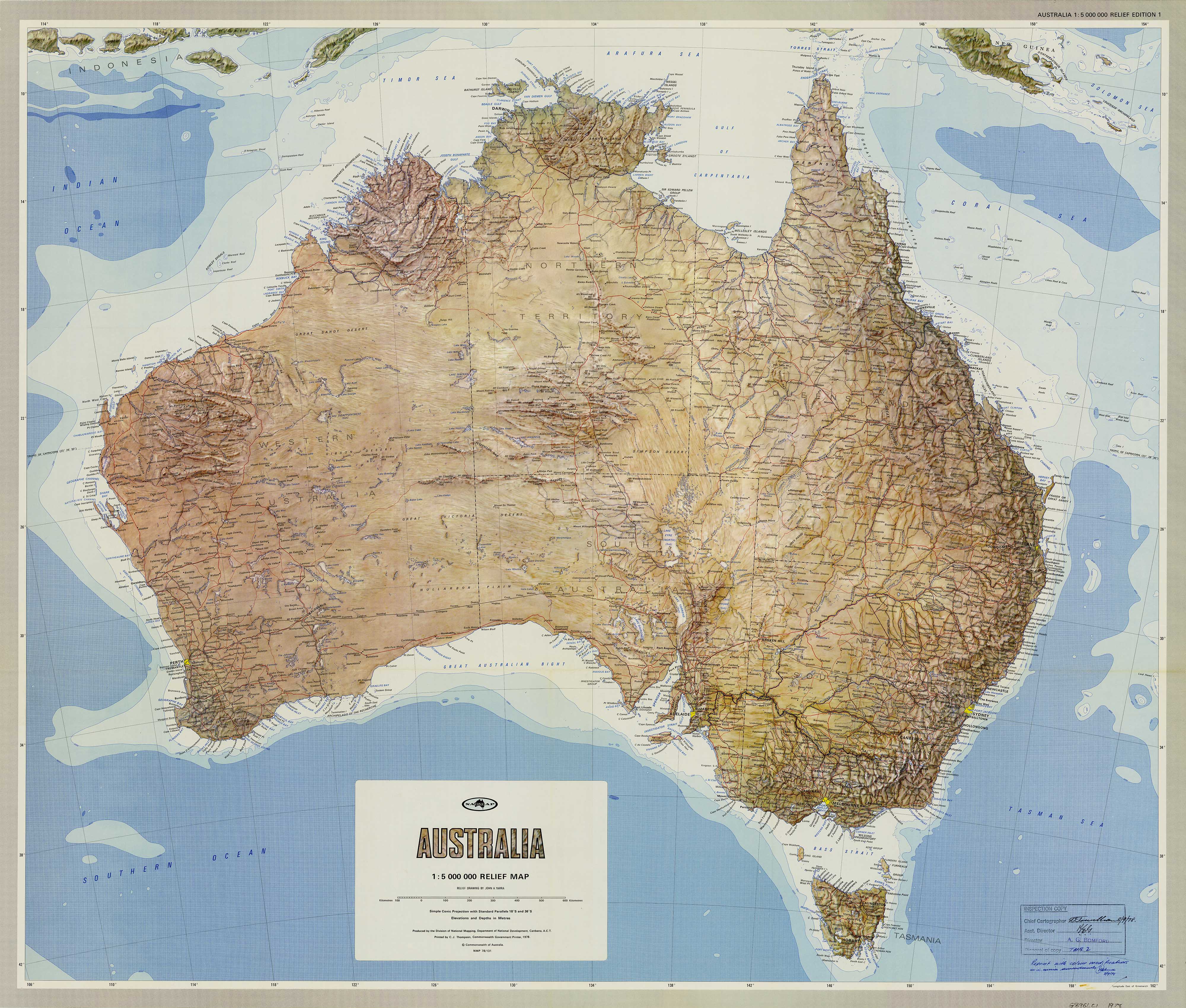
🗺️ A beautifully detailed vintage physical map capturing the diverse landforms of Australia in a pre-digital era. Professionally reproduced on premium materials for collectors, educators, and interior display.
🧭 A Vintage Geographic Masterpiece
Step back to 1978 with this exceptional Physical Wall Map of Australia, originally produced by the Commonwealth’s Division of National Mapping. This is more than a map—it is a snapshot of how Australia’s geography was portrayed at a time when hand-rendered cartography was still a national artform.
Emphasising elevation and terrain through subtle colour gradients and relief shading, the map provides a broad understanding of Australia’s mountain ranges, deserts, rivers, basins, and coastal plains.
Whether you're teaching, decorating, collecting, or simply admiring the natural beauty of the continent, this reprint offers both accuracy and timeless appeal.
🌏 Map Features at a Glance
-
🏔️ Physical Relief Detail – Highlights Australia’s diverse landforms including:
-
The Great Dividing Range
-
The MacDonnell Ranges
-
Nullarbor Plain
-
Central Deserts, basins, and plateaus
-
-
🌊 Hydrological Features – Rivers, lakes, and the Great Artesian Basin clearly marked
-
🧭 State & Territory Boundaries – Overlayed for easy reference within the physical landscape
-
🗺️ Coastal Emphasis – Major ports and maritime landmarks subtly included
-
📅 Vintage Styling – Authentic 1970s design and typography for period accuracy
-
🖋️ Produced by the Division of National Mapping, renowned for government-grade mapping
🖨️ Available in Premium Finishes
All versions are printed with archival-quality clarity and fade-resistant inks, offering you both durability and display-worthy beauty.
📄 160gsm Matte Paper
✔ Smooth, uncoated finish
✔ Crisp colour and detail
✔ Ideal for traditional framing under glass
💧 Laminated (Encapsulated Gloss)
✔ Sealed between two sheets of 80-micron gloss laminate
✔ Tear-resistant and water-resistant
✔ Wipeable surface – perfect for classrooms and shared spaces
✔ Long-lasting and low maintenance
🖼️ 395gsm HP Professional Matte Canvas
✔ Heavy-duty cotton blend canvas
✔ Printed using pigment-based, fade-resistant archival inks
✔ Non-glare, textured matte finish for enhanced visual depth
✔ Extremely durable – perfect for frequent use or long-term display
✔ Optional timber hang rails for a gallery-style look
⏳ Please allow up to 10 business days for canvas maps with hang rails, as each is fitted by hand by our expert framer.
🪵 Timber Hang Rail Option (for Canvas Finish)
Upgrade your canvas map with hand-lacquered timber battens:
-
🪵 Natural wood finish, top and bottom
-
🧵 Discreet hanging cord for effortless wall mounting
-
🎯 All you need is a single wall hook
-
🖐️ Professionally assembled by our framer in Sydney
📐 Full Specifications
| Feature | Details |
|---|---|
| Map Title | Physical Wall Map of Australia (1978) |
| Publisher | Division of National Mapping |
| Publication Date | 1978 |
| Map Type | Physical (topography, relief, and natural features) |
| Size | 996 mm (W) x 846 mm (H) |
| Scale | Not specified on source – large format physical overview |
| Material Options | Matte Paper / Laminated / Canvas |
| Canvas Weight | 395 gsm (heavyweight professional canvas) |
| Ink Type | Pigment-based archival inks (canvas version) |
| Finish Options | Rolled or with Timber Hang Rails |
| Made In | Australia |
🧳 Who Is This Map For?
-
🎓 Educators teaching physical geography or Australian landforms
-
🏡 Interior decorators seeking vintage or academic-style wall art
-
🧭 Cartography lovers and collectors of historical maps
-
🏫 Classrooms and learning environments that need durable, visual learning tools
-
🎁 Gift idea for geographers, historians, or anyone with a love of Australia’s natural world
🇦🇺 Proudly Made in Australia
All versions of this map are locally printed and finished using premium materials, archival inks, and attention to historic authenticity. Whether for professional use or personal appreciation, this map offers a timeless perspective on the Australian continent—as it was drawn in an era of precise, handcrafted cartography.
🛒 Order Today – Choose Your Finish Above
-
Paper (rolled) – Perfect for framing
-
Encapsulated Laminate – Tough and practical
-
Canvas – Durable and display-ready
-
Canvas with Timber Hang Rails – A premium, ready-to-hang statement piece
Rediscover Australia’s geography—rugged, remote, and remarkable.
This 1978 physical map is both a functional reference and a historic work of art. Display it with pride, use it with confidence.


