- Australia ▾
- Topographic
▾
- Australia AUSTopo 250k (2025)
- Australia 50k Geoscience maps
- Australia 100k Geoscience maps
- Australia 250k Geoscience maps
- Australia 1:1m Geoscience maps
- New Zealand 50k maps
- New Zealand 250k maps
- New South Wales 25k maps
- New South Wales 50k maps
- New South Wales 100k maps
- Queensland 10k maps
- Queensland 25k maps
- Queensland 50k maps
- Queensland 100k maps
- Western Australia 25k maps
- Western Australia 50k maps
- Western Australia 100k maps
- Compasses
- Software
- GPS Systems
- International ▾
- Wall Maps
▾
- World
- Australia & New Zealand
- Countries, Continents & Regions
- Historical
- Vintage National Geographic
- Australian Capital Territory
- New South Wales
- Northern Territory
- Queensland
- South Australia
- Tasmania
- Victoria
- Western Australia
- Celestial
- Children's
- Mining & Resources
- Wine Maps
- Healthcare
- Postcode Maps
- Electoral Maps
- Nautical ▾
- Flags
▾
- Australian Flag Sets & Banners
- Flag Bunting
- Handwavers
- Australian National Flags
- Aboriginal Flags
- Torres Strait Islander Flags
- International Flags
- Flagpoles & Accessories
- Australian Capital Territory Flags
- New South Wales Flags
- Northern Territory Flags
- Queensland Flags
- South Australia Flags
- Tasmania Flags
- Victoria Flags
- Western Australia Flags
- Gifts ▾
- Globes ▾
Dear valued customer. Please note that our checkout is not supported by old browsers. Please use a recent browser to access all checkout capabilities


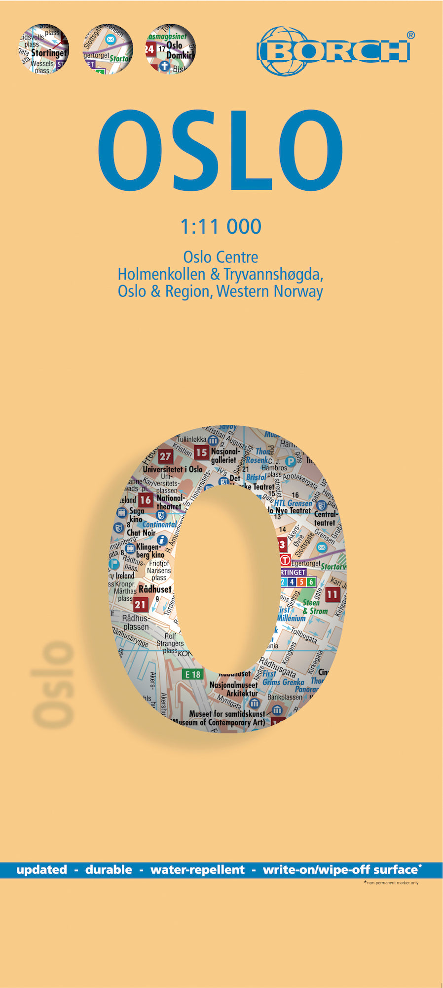
Oslo Borch Folded Laminated Map
$21.95
Afterpay is only available for orders between $50.00 and $1000.00 More info
Laminated Travel Map | Folded | Multi-Scale | Includes Public Transport & Regional Maps
Explore Norway’s capital with a durable, compact, and beautifully detailed city map.
🌆 Discover Oslo with Confidence and Clarity
The Borch Laminated City Map of Oslo is your ultimate navigation companion in one of Europe’s most livable capitals. Waterproof, tear-resistant, and thoughtfully designed, this soft-laminated folding map combines high-precision cartography with cultural insight. Perfect for urban explorers, cruise passengers, business travellers, or those discovering Oslo for the first time.
With five detailed map scales — from city centre to regional views — and an abundance of practical information, this is far more than a map. It’s a travel tool.
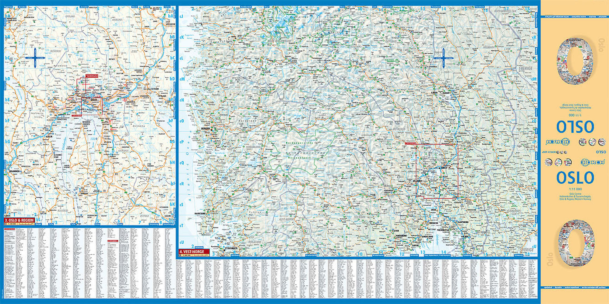
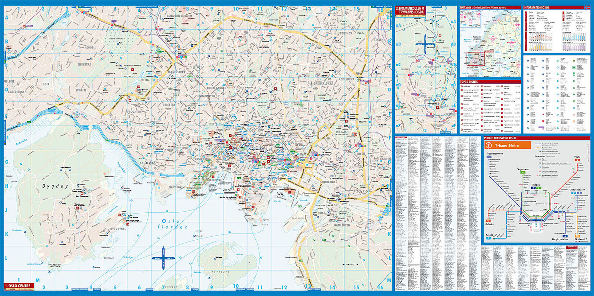
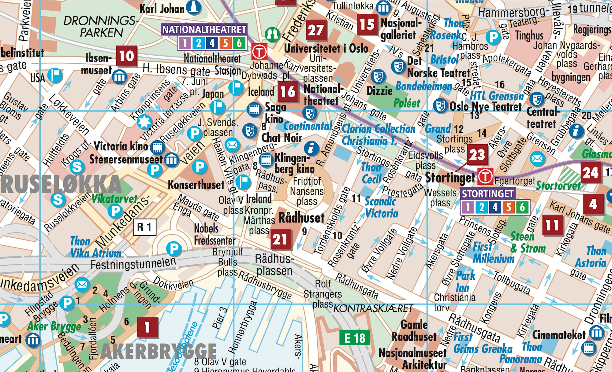
🌟 Map Coverage & Scales
| 🗺️ Map Section | 🔍 Scale |
|---|---|
| Oslo City Centre | 1:11,000 |
| Holmenkollen & Tryvannshøgda | 1:25,000 |
| Oslo & Surrounding Region | 1:200,000 |
| Western Norway (Vest-Norge) | 1:800,000 |
| Public Transport Map – Oslo | Schematic overview |
| Norway Administrative Divisions & Time Zones | National overview |
🧭 Key Features
| Feature | Benefit |
|---|---|
| 🧊 Laminated & Waterproof | Wipe-clean surface, ideal for outdoor use and variable Nordic weather |
| 🧳 Compact & Folded Format | Travel-ready size fits easily into daypacks or carry-ons |
| 📍 Top 30 Sights Highlighted | Must-see attractions clearly marked for easy discovery |
| 🗺️ Multiple Map Scales | City, suburb, regional and national perspectives all in one |
| 🚋 Public Transport Overview | Includes metro, tram, bus and ferry routes for seamless urban mobility |
| 🌦️ Climate Charts | Temperature, sunshine hours, humidity, and precipitation at a glance |
| 🎯 Travel Essentials | Hotels, museums, monuments, markets, parks, and cultural highlights |
| 📊 Useful Conversions | Quick-reference charts for weights, measures, and temperatures |
🏙️ About Oslo
-
Founded: c.1048 by King Harald III
-
Population: Approx. 1.4 million (metro area)
-
Geography: Located at the northern end of the Oslofjord
-
City Features:
-
40 islands and 343 lakes within city limits
-
Home to the Nobel Peace Center
-
Surrounded by forests, waterfalls, and nature trails
-
-
Climate:
-
Summer: Long daylight hours (up to 18 hours), mild to warm with occasional heatwaves
-
Winter: Short daylight (as little as 6 hours), with snowfall from January to March
-
-
Cultural Life:
-
Music, film, food and arts festivals year-round
-
Excellent public transport system and safe, walkable streets
-
World-class museums, galleries, and green spaces
-
📐 Product Specifications
| Specification | Detail |
|---|---|
| Map Title | Oslo Borch Folded Laminated Map |
| Publisher | Borch Maps (Germany) |
| Edition | 6th Edition (2016) |
| ISBN | 978-3-86609-310-2 |
| Scale | Multiple (1:11,000 to 1:800,000) |
| Map Size (Open) | 990 mm (W) x 494 mm (H) / 39 in x 19.5 in |
| Folded Size | 243 x 110 x 8 mm / 9.6 x 4.3 x 0.3 in |
| Weight | 81 g / 2.9 oz |
| Material | Soft-laminated, waterproof, tear-resistant |
🎯 Ideal For:
-
🧭 Independent travellers navigating Oslo and its surrounds
-
🛳️ Cruise passengers arriving into the Oslofjord
-
🎒 Backpackers and urban explorers
-
📚 Students and geography enthusiasts
-
🎁 Thoughtful gift for travellers and cartophiles
Explore Oslo with a map as well-made as the city itself.
Durable. Informative. Compact. Ready for your next Nordic adventure.
Frequently Asked Questions
Where can I buy the Oslo Borch Folded Laminated Map?
The Oslo Borch Folded Laminated Map is available to buy online from Mapworld, Australia's largest map and geographic product retailer, with fast shipping Australia-wide.
Is the Oslo Borch Folded Laminated Map in stock at Mapworld?
Mapworld maintains extensive stock across its map range and aims for fast dispatch. Orders placed before 2pm AEST on business days are typically dispatched the same day, with standard and express Australia-wide delivery options available.
What is Mapworld's returns policy?
Mapworld accepts returns on undamaged items in original condition. Contact Mapworld within 90 days of purchase to arrange a return or exchange.
Does Mapworld ship the Oslo Borch Folded Laminated Map across Australia?
Yes, Mapworld ships Australia-wide. Standard shipping is a flat $7 rate, with free standard shipping on orders over $75. Express options are available at checkout. Most orders placed before 2pm AEST on weekdays are dispatched same day.
Related Items


© 2026 Mapworld. Website designed by Genie Media
X