- Australia ▾
- Topographic
▾
- Australia AUSTopo 250k (2024)
- Australia 50k Geoscience maps
- Australia 100k Geoscience maps
- Australia 250k Geoscience maps
- Australia 1.1m Geoscience maps
- New Zealand 50k maps
- New Zealand 250k maps
- New South Wales 25k maps
- New South Wales 50k maps
- New South Wales 100k maps
- Queensland 10k maps
- Queensland 25k maps
- Queensland 50k maps
- Queensland 100k maps
- Compasses
- Software
- GPS Systems
- Orienteering
- International ▾
- Wall Maps
▾
- World
- Australia & New Zealand
- Countries, Continents & Regions
- Historical
- Vintage National Geographic
- Australian Capital Territory
- New South Wales
- Northern Territory
- Queensland
- South Australia
- Tasmania
- Victoria
- Western Australia
- Celestial
- Children's
- Mining & Resources
- Wine Maps
- Healthcare
- Postcode Maps
- Electoral Maps
- Nautical ▾
- Flags
▾
- Australian Flag Sets & Banners
- Flag Bunting
- Handwavers
- Australian National Flags
- Aboriginal Flags
- Torres Strait Islander Flags
- International Flags
- Flagpoles & Accessories
- Australian Capital Territory Flags
- New South Wales Flags
- Northern Territory Flags
- Queensland Flags
- South Australia Flags
- Tasmania Flags
- Victoria Flags
- Western Australia Flags
- Gifts ▾
- Globes ▾
Dear valued customer. Please note that our checkout is not supported by old browsers. Please use a recent browser to access all checkout capabilities
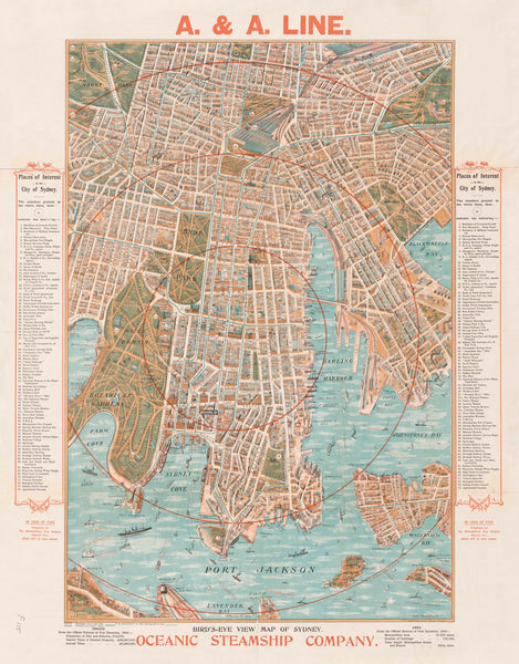
Oceanic Steamship Wall Map of Sydney (Port Jackson) published 1905
$69.95
or make 4 interest-free payments of
$17.49 AUD
fortnightly with
![]() More info
More info
An Illustrated Masterpiece of Edwardian Sydney Harbour
This stunning reproduction of the Oceanic Steamship Company's 1905 birds-eye view of Sydney (Port Jackson) offers an unparalleled glimpse into the city's maritime past. Created by John Andrew, a master lithographer of the time, this map was originally printed as a luxurious souvenir for first-class passengers arriving by ocean liner—a token of refinement, civic pride, and imperial splendour.
Drawn in a richly detailed oblique perspective, this map captures not only the geography of early 20th century Sydney but also its social and architectural fabric. From the Government House to Circular Quay, The Rocks, Fort Denison, and the Sydney Cricket Ground, each building and ferry route is illustrated with meticulous care. The map includes an index of 74 points of interest, providing a fascinating key to the city as it stood over a century ago.
This is more than just a map—it’s a window into Edwardian Sydney, a time when grand ocean liners dominated the harbour, trams trundled through sandstone streets, and the skyline was crowned by church spires and smoke stacks.
Historical Significance
-
Originally published in 1905 by John Andrew for the Oceanic Steamship Company
-
A unique perspective of Sydney Harbour during the pre-Harbour Bridge era
-
Includes a 74-point index of landmarks, from ferry terminals and military barracks to pleasure grounds and cricket ovals
-
A rare example of early promotional cartography blending navigation, tourism, and art
Exceptional Print Options
Choose from three premium finishes, each crafted to suit different display settings—from home libraries and heritage halls to classrooms and boardrooms:
| Finish | Description |
|---|---|
| Paper (160gsm heavyweight) | Ideal for framing under glass. Offers a smooth, high-resolution finish perfect for archival display or interior styling. |
| Laminated (Encapsulated 80 Micron Gloss) | Durable, wipeable, and UV-resistant. Excellent for offices, libraries, and education settings. Allows use of whiteboard markers and removable map dots. |
| Canvas (395gsm HP Professional Matte Canvas) | Museum-grade canvas printed with archival pigment inks for unmatched depth, longevity, and richness of colour. Stunning texture, fade-resistant, and built to last for decades. |
Optional Hanging System – Timber Rails
For the ultimate ready-to-hang solution, select the hang-railed option for either the laminated or canvas versions. We attach natural timber battens at the top and bottom, with a matching cotton hanging cord. The rails are finished in a satin lacquer, creating a clean, timeless look that complements both traditional and modern interiors.
Please allow up to 10 working days for delivery of hang-railed versions, as these are individually fitted by our professional framer.
Available Sizes
| Size Name | Dimensions |
|---|---|
| Large | 665 mm (W) × 850 mm (H) |
| Supermap | 1000 mm (W) × 1300 mm (H) |
Product Summary
-
Title: Oceanic Steamship Wall Map of Sydney (Port Jackson), 1905
-
Publisher: John Andrew (Reproduction)
-
Original Publication Date: 1905
-
Reproduction: Printed and finished in Australia
-
Material Options: Paper, Laminated, Canvas
-
Optional: Hang rails on laminated and canvas versions
-
Framing Suitability: Perfect for under-glass or rail display
-
Use: Decorative, educational, historical reference, gift
Perfect For
-
Lovers of maritime history and Australian cartography
-
Collectors of vintage and heritage maps
-
Interior decorators seeking antique flair
-
Corporate gifts for clients or history-minded colleagues
-
Classrooms, libraries, and public buildings wanting a conversation piece
This map is a celebration of Sydney’s harbour heritage, brought vividly to life with old-world artistry and modern printing excellence. Whether displayed in a boardroom or above a fireplace, it is a piece that invites closer inspection, reflection, and admiration.


