- Australia ▾
- Topographic
▾
- Australia AUSTopo 250k (2024)
- Australia 50k Geoscience maps
- Australia 100k Geoscience maps
- Australia 250k Geoscience maps
- Australia 1.1m Geoscience maps
- New Zealand 50k maps
- New Zealand 250k maps
- New South Wales 25k maps
- New South Wales 50k maps
- New South Wales 100k maps
- Queensland 10k maps
- Queensland 25k maps
- Queensland 50k maps
- Queensland 100k maps
- Compasses
- Software
- GPS Systems
- Orienteering
- International ▾
- Wall Maps
▾
- World
- Australia & New Zealand
- Countries, Continents & Regions
- Historical
- Vintage National Geographic
- Australian Capital Territory
- New South Wales
- Northern Territory
- Queensland
- South Australia
- Tasmania
- Victoria
- Western Australia
- Celestial
- Children's
- Mining & Resources
- Wine Maps
- Healthcare
- Postcode Maps
- Electoral Maps
- Nautical ▾
- Flags
▾
- Australian Flag Sets & Banners
- Flag Bunting
- Handwavers
- Australian National Flags
- Aboriginal Flags
- Torres Strait Islander Flags
- International Flags
- Flagpoles & Accessories
- Australian Capital Territory Flags
- New South Wales Flags
- Northern Territory Flags
- Queensland Flags
- South Australia Flags
- Tasmania Flags
- Victoria Flags
- Western Australia Flags
- Gifts ▾
- Globes ▾
Dear valued customer. Please note that our checkout is not supported by old browsers. Please use a recent browser to access all checkout capabilities


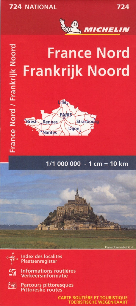
Northern France Michelin Map 724
$21.95
Afterpay is only available for orders between $50.00 and $1000.00 More info
Scale: 1:1,000,000 | Single-Sided Paper Map | Multilingual Key
Covers Northern France in Full Detail | Ideal for Driving Holidays & Regional Exploration
Explore the Charm of Northern France with Michelin Precision
Planning a road trip through Normandy’s historic coastlines, tracing the Champagne Route, or navigating to Paris, Lille, or Calais? The Michelin Northern France Map (No. 724) is your indispensable guide for seamless travel across the northern regions of France.
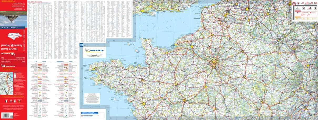
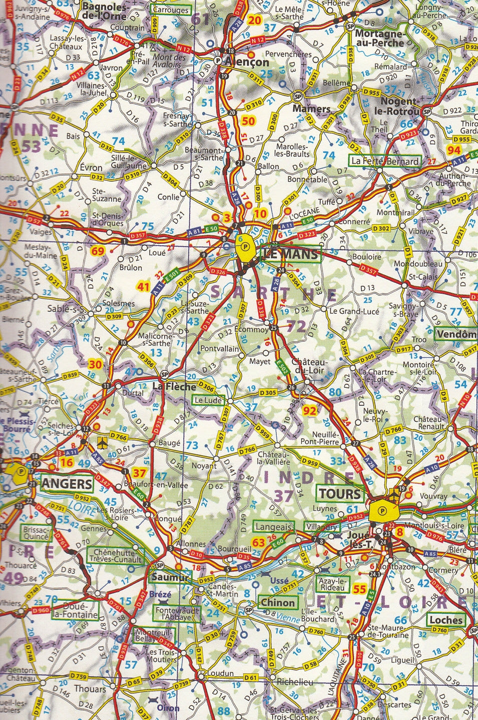
This expertly designed road map covers the top half of France, including key regions such as Île-de-France, Normandy, Picardy, Hauts-de-France, Alsace, and Champagne-Ardenne, with clear roads, scenic routes, and essential travel data. It is the upper section of the Michelin France Map 721, with identical scale and legendary cartographic clarity.
Produced by Michelin, one of Europe’s most respected mapmakers, this paper map is perfect for self-drive tourists, travel agents, overlanders, and Francophile adventurers.
Coverage Highlights
-
Major Cities & Towns: Paris, Rouen, Reims, Lille, Calais, Amiens, Nancy, Strasbourg, Metz & more
-
Regions of Interest: Champagne, Alsace wine country, Picardy battlefields, Normandy landing beaches
-
International Links: Border crossings into Belgium, Luxembourg, and Germany clearly marked
-
Coastal & Scenic Drives: Highlights popular touring routes along the Seine, Marne, and northern coastline
Map Features
| Feature | Description |
|---|---|
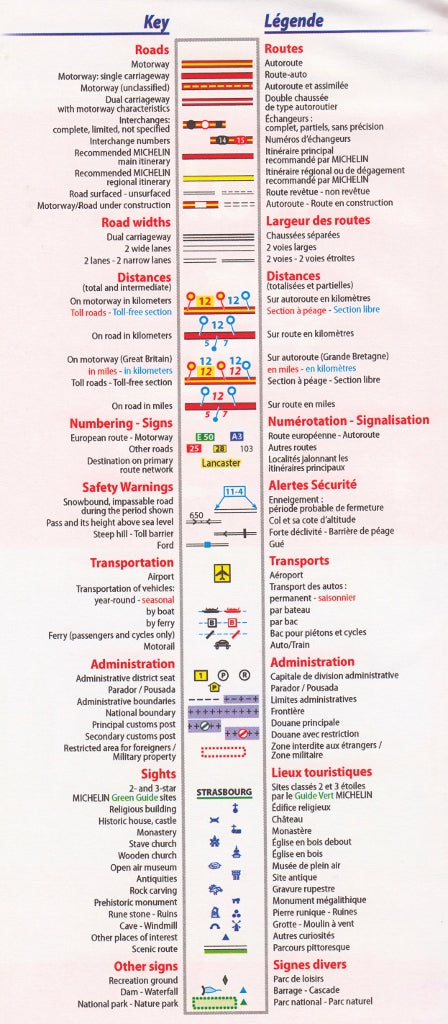
| 🛣️ Road Network | Motorways, national, regional, and secondary roads, with clear route numbers |
| 🧭 Borders & Access Points | International boundaries clearly marked with connecting routes |
| 📍 Place Names | Shown in local French, just as they appear on road signs |
| 🗺️ Tourist Icons | Includes symbols for parks, scenic routes, historical sites, ferry ports, and more |
| 📏 Distance Charts | Distances shown in kilometres with drive-time estimates |
| 🗂️ Multilingual Key | Legend in English, French, German, Spanish, and more |
💬 Language Notes
-
Place names are presented in their local spelling (French) for on-the-ground navigation ease
-
Map cover language may vary (English, French, or German), but all versions include the same map content and multilingual key
Who This Map Is For
-
🚗 Road Trippers & Self-Drive Travellers – Navigate rural France, wine regions, and coastal drives with ease
-
🗺️ Tour Planners & Agents – Ideal for creating itineraries that explore cultural and scenic routes
-
🚐 Overlanders & RV Users – An excellent backup or complement to GPS-based systems
-
📚 Map Collectors & Enthusiasts – A classic addition to any European road atlas collection
-
✈️ International Travellers – Particularly helpful for visitors renting cars in France and travelling independently
📏 Product Specifications
| Attribute | Detail |
|---|---|
| Map Title | Michelin Map 724 – Northern France |
| Scale | 1:1,000,000 |
| Map Type | Single-sided folded paper map |
| Coverage Area | Northern France (top half of Michelin Map 721) |
| Legend Languages | English, French, German, Spanish, and more |
| Place Names | Shown in local language (French) |
| Size | 1000 mm (W) x 500 mm (H) |
| Publisher | Michelin Travel Publications |
| Printed In | Europe 🇪🇺 |
🛒 Add to Cart Today
Whether you're tracing the footsteps of Joan of Arc, enjoying a wine route through Reims, or venturing north toward Belgium, the Michelin Northern France Map 724 offers the detail, clarity, and reliability you expect from one of the world’s finest mapmakers.
👉 Order now to start planning your road adventure through the captivating landscapes, history, and culture of Northern France.


