- Australia ▾
- Topographic
▾
- Australia AUSTopo 250k (2025)
- Australia 50k Geoscience maps
- Australia 100k Geoscience maps
- Australia 250k Geoscience maps
- Australia 1:1m Geoscience maps
- New Zealand 50k maps
- New Zealand 250k maps
- New South Wales 25k maps
- New South Wales 50k maps
- New South Wales 100k maps
- Queensland 10k maps
- Queensland 25k maps
- Queensland 50k maps
- Queensland 100k maps
- Western Australia 25k maps
- Western Australia 50k maps
- Western Australia 100k maps
- Compasses
- Software
- GPS Systems
- International ▾
- Wall Maps
▾
- World
- Australia & New Zealand
- Countries, Continents & Regions
- Historical
- Vintage National Geographic
- Australian Capital Territory
- New South Wales
- Northern Territory
- Queensland
- South Australia
- Tasmania
- Victoria
- Western Australia
- Celestial
- Children's
- Mining & Resources
- Wine Maps
- Healthcare
- Postcode Maps
- Electoral Maps
- Nautical ▾
- Flags
▾
- Australian Flag Sets & Banners
- Flag Bunting
- Handwavers
- Australian National Flags
- Aboriginal Flags
- Torres Strait Islander Flags
- International Flags
- Flagpoles & Accessories
- Australian Capital Territory Flags
- New South Wales Flags
- Northern Territory Flags
- Queensland Flags
- South Australia Flags
- Tasmania Flags
- Victoria Flags
- Western Australia Flags
- Gifts ▾
- Globes ▾
Dear valued customer. Please note that our checkout is not supported by old browsers. Please use a recent browser to access all checkout capabilities


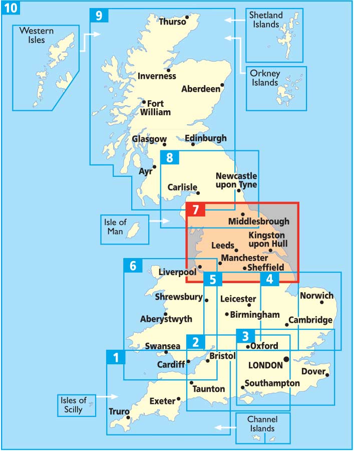

Northern England AA Road Map 7
$19.95
Afterpay is only available for orders between $50.00 and $1000.00 More info
Scale: 1:200,000 (3 miles to 1 inch) | Size: 1200 mm x 980 mm | Folded Paper Map
Published by the AA – Britain’s Trusted Name in Road Mapping
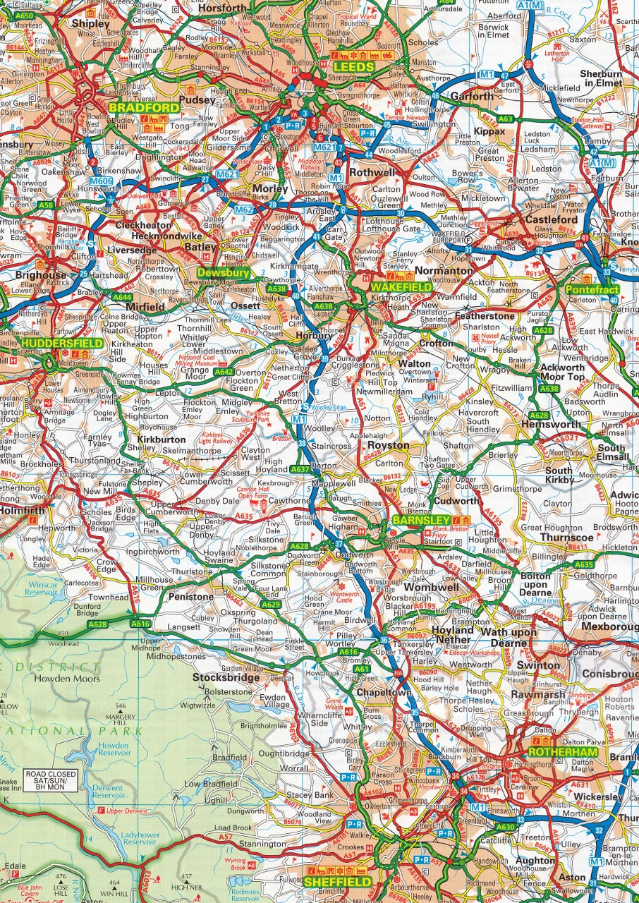
Navigate the north of England with confidence using the 2024 edition of the AA Northern England Road Map—a fully updated, easy-to-read folded map designed for both everyday drivers and adventurous road-trippers. Covering a vast region from major motorways to scenic country lanes, this map combines practicality with extensive tourist detail, all in a portable format with a durable, weatherproof outer cover.
✅ Key Features & Benefits
Comprehensive Road Network Coverage
At a scale of 1:200,000 (2 km to 1 cm), this map shows:
-
Motorways, A-roads, B-roads, and rural routes
-
Road numbers, dual carriageways, and toll points
-
Service areas, junctions, and lay-bys clearly marked
Fully Updated Speed Camera Locations (2024)
-
Includes camera locations with speed limits to help you plan your journey safely
-
Keeps you aware and informed while navigating unfamiliar routes
Highlighting Tourist & Heritage Sites
-
National Parks and scenic areas distinctly marked
-
National Trust, English Heritage, Scottish and Welsh Heritage locations clearly identified
-
Ideal for planning weekend breaks or longer holidays in the North
Campsites & Caravan Parks Included
-
Locations of caravan parks and campgrounds are pinpointed directly on the map—perfect for touring holidays
City & Town Plans Included
Inset street-level plans of 10 key urban centres:
-
Leeds, Lancaster, Kingston-upon-Hull, Harrogate, Bradford, Liverpool, Manchester, Scarborough, Sheffield, and York
Each plan offers clear city centre mapping ideal for finding parking, attractions, and main roads
Clear Place Name Index
-
Extensive place name index for quick lookup
-
Easily locate even the smallest villages, hamlets, and suburban areas
Product Specifications
| Feature | Description |
|---|---|
| Title | Northern England Road Map 7 |
| Publisher | AA (Automobile Association) |
| Format | Folded paper map with weather-resistant cover |
| Scale | 1:200,000 (3 miles to 1 inch / 2 km to 1 cm) |
| Size (Unfolded) | 1200 mm x 980 mm |
| Publication Year | 2024 |
| Inset Maps | 10 city & town centre plans |
| Extras | Speed cameras, National Parks, heritage sites, campsites, index |
Perfect For:
✔️ Everyday Motorists & Commuters – Reliable backup to GPS navigation
✔️ Road Trippers & Holidaymakers – Plan scenic detours and heritage stops
✔️ Caravan & Camping Enthusiasts – Locate campgrounds easily
✔️ History Buffs & Nature Lovers – Discover castles, museums, and national parks
✔️ Teachers & Map Enthusiasts – An educational and practical British reference
With its blend of clarity, accuracy, and practicality, the AA Northern England Road Map is an indispensable tool for anyone navigating this rich and varied part of the UK. Whether you’re heading to the Lake District, tracing the coastline of Yorkshire, or exploring the cultural heart of cities like Liverpool or Manchester, this map brings the North of England to life—road by road, turn by turn.
🛒 Add to Cart Today and explore Northern England with the trusted navigation tool that’s as reliable on the road as it is on your lap.
Frequently Asked Questions
What area does the Northern England AA Road Map 7 cover?
The Northern England AA Road Map 7 provides road coverage of the region named in the product title. The map covers major cities, highways, towns, and regional roads, with inset city maps for key urban centres where applicable.
Is the Northern England AA Road Map 7 up to date?
Yes, this is the current edition. Mapworld stocks the most current editions from all major publishers, updated to reflect new roads and infrastructure.
What size is this map when unfolded?
Folded maps from Mapworld's range are compact and portable. Most standard folded road or travel maps open to between A1 (594 × 841mm) and A0 (841 × 1189mm) when fully unfolded, and fold down to approximately A4 or smaller for easy storage in a glove box, bag, or backpack.
Is the Northern England AA Road Map 7 in stock at Mapworld?
Mapworld maintains extensive stock across its map range and aims for fast dispatch. Orders placed before 2pm AEST on business days are typically dispatched the same day, with standard and express Australia-wide delivery options available.
Does Mapworld ship the Northern England AA Road Map 7 across Australia?
Yes, Mapworld ships Australia-wide. Standard shipping is a flat $7 rate, with free standard shipping on orders over $75. Express options are available at checkout. Most orders placed before 2pm AEST on weekdays are dispatched same day.
Related Items


© 2026 Mapworld. Website designed by Genie Media
X