- Australia ▾
- Topographic
▾
- Australia AUSTopo 250k (2025)
- Australia 50k Geoscience maps
- Australia 100k Geoscience maps
- Australia 250k Geoscience maps
- Australia 1:1m Geoscience maps
- New Zealand 50k maps
- New Zealand 250k maps
- New South Wales 25k maps
- New South Wales 50k maps
- New South Wales 100k maps
- Queensland 10k maps
- Queensland 25k maps
- Queensland 50k maps
- Queensland 100k maps
- Compasses
- Software
- GPS Systems
- Orienteering
- International ▾
- Wall Maps
▾
- World
- Australia & New Zealand
- Countries, Continents & Regions
- Historical
- Vintage National Geographic
- Australian Capital Territory
- New South Wales
- Northern Territory
- Queensland
- South Australia
- Tasmania
- Victoria
- Western Australia
- Celestial
- Children's
- Mining & Resources
- Wine Maps
- Healthcare
- Postcode Maps
- Electoral Maps
- Nautical ▾
- Flags
▾
- Australian Flag Sets & Banners
- Flag Bunting
- Handwavers
- Australian National Flags
- Aboriginal Flags
- Torres Strait Islander Flags
- International Flags
- Flagpoles & Accessories
- Australian Capital Territory Flags
- New South Wales Flags
- Northern Territory Flags
- Queensland Flags
- South Australia Flags
- Tasmania Flags
- Victoria Flags
- Western Australia Flags
- Gifts ▾
- Globes ▾
Dear valued customer. Please note that our checkout is not supported by old browsers. Please use a recent browser to access all checkout capabilities


Night Sky - Northern Hemisphere Folded Map
$28.95
Afterpay is only available for orders between $50.00 and $1000.00 More info
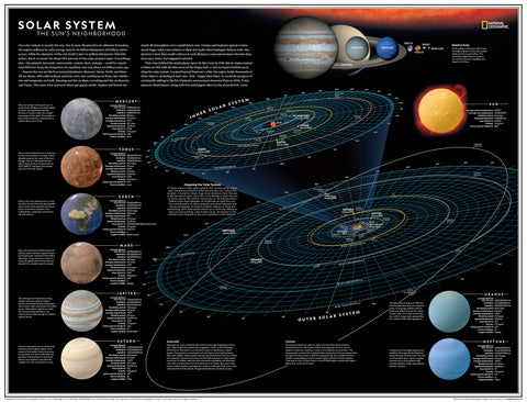
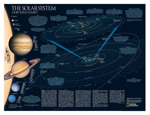
Every culture has drawn pictures in the stars, creating constellations that represent animals or mythic figures. Ancient astronomers peered into the night sky and imagined glittering jewels set in a crystal sphere slowly revolving around the Earth from east to west. The 88 constellations recognized today by the International Astronomical Union (IAU) are not just pictures but basic units that partition the sky.
The Night Sky - Northern Hemisphere Stargazer Map and Guide is centered on Polaris, the North Star, which appears fixed in place with the other stars on the chart rotating around it. Thus it has long aided navigators in determining both direction and latitude. The constellations and brighter stars are labeled with their latin names. The map includes a table of star magnitude or brightness. As the Earth moves in its orbit around the Sun the constellations in the sky change.
The Night Sky map includes four seasonal charts that are specific for each season: spring, summer, autumn, and winter. Every Stargazer Map is printed on durable synthetic paper, making them waterproof, tear-resistant and tough — capable of withstanding the rigors of repeated outdoor use.
This product is order on-demand so please allow 10 business days for delivery