- Australia ▾
- Topographic
▾
- Australia AUSTopo 250k (2024)
- Australia 50k Geoscience maps
- Australia 100k Geoscience maps
- Australia 250k Geoscience maps
- Australia 1.1m Geoscience maps
- New Zealand 50k maps
- New Zealand 250k maps
- New South Wales 25k maps
- New South Wales 50k maps
- New South Wales 100k maps
- Queensland 10k maps
- Queensland 25k maps
- Queensland 50k maps
- Queensland 100k maps
- Compasses
- Software
- GPS Systems
- Orienteering
- International ▾
- Wall Maps
▾
- World
- Australia & New Zealand
- Countries, Continents & Regions
- Historical
- Vintage National Geographic
- Australian Capital Territory
- New South Wales
- Northern Territory
- Queensland
- South Australia
- Tasmania
- Victoria
- Western Australia
- Celestial
- Children's
- Mining & Resources
- Wine Maps
- Healthcare
- Postcode Maps
- Electoral Maps
- Nautical ▾
- Flags
▾
- Australian Flag Sets & Banners
- Flag Bunting
- Handwavers
- Australian National Flags
- Aboriginal Flags
- Torres Strait Islander Flags
- International Flags
- Flagpoles & Accessories
- Australian Capital Territory Flags
- New South Wales Flags
- Northern Territory Flags
- Queensland Flags
- South Australia Flags
- Tasmania Flags
- Victoria Flags
- Western Australia Flags
- Gifts ▾
- Globes ▾
Dear valued customer. Please note that our checkout is not supported by old browsers. Please use a recent browser to access all checkout capabilities


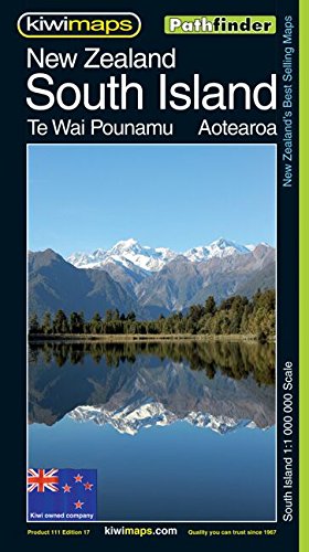
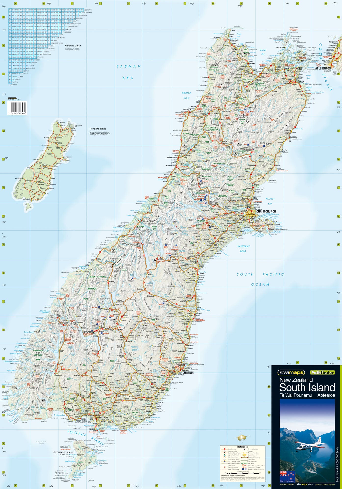
New Zealand South Island Kiwimaps Folded Map
$14.95 $16.95
Afterpay is only available for orders between $50.00 and $1000.00 More info
Discover the dramatic landscapes, winding roads, and remote beauty of New Zealand’s South Island with this expertly produced touring map from Kiwimaps—New Zealand’s definitive mapping company.
Trusted by travellers, tour planners, and locals alike, this map is always up to date, always accurate, and designed with the touring adventurer in mind. Whether you're planning to explore the Fiordlands, cross the Southern Alps, or wind your way along the rugged West Coast, this map offers the clarity, detail, and reliability you need.
🗺️ Comprehensive Coverage of the South Island
Covering the entirety of the South Island at 1:1,000,000 scale, this map provides a wide-view perspective while still retaining essential detail for travel and route planning. From the cities of Christchurch, Dunedin, and Nelson to the glaciers, lakes, and mountain ranges of the wilderness interior, it’s all here—clearly marked and indexed.
🔍 Map Features Include:
-
🚗 All Major & Regional Roads – Ideal for route planning whether by car, campervan, or motorbike
-
🏞️ Recreational & Natural Features – Lakes, rivers, national parks, glaciers, and mountains
-
🧭 Distance Table – Plan your drive times and stops with precision
-
⏱️ Travel Time Map – A helpful inset showing approximate driving times between key destinations
-
📍 Full Index – Includes:
-
Cities and towns
-
Rivers and lakes
-
Islands
-
Mountains and glaciers
-
Recreation areas, parks, and reserves
-
Whether you're exploring Milford Sound, heading to Aoraki/Mount Cook, or ferrying between Picton and Wellington, this map offers the confidence of complete preparation.
📐 Specifications:
| Feature | Detail |
|---|---|
| Publisher | Kiwimaps – New Zealand’s definitive mapmaker |
| Scale | 1:1,000,000 |
| Size | 615 mm x 880 mm |
| Format | Folded touring map |
| Index | Comprehensive – towns, rivers, natural features, and more |
| Extras | Distance table + travel time inset map |
🧭 Who Is This Map For?
-
🚐 Road trippers & campervan travellers covering long distances across the South Island
-
🏞️ Nature lovers & hikers looking to reach trails, glaciers, lakes, and remote spots
-
🧳 Overseas visitors exploring Aotearoa for the first time
-
🎁 Gift buyers seeking a practical and thoughtful New Zealand keepsake
-
📚 Educators and students needing a full-picture view of the South Island’s geography
-
🏕️ Touring cyclists, photographers, and freedom campers wanting signal-free navigation
📌 Why Choose a Kiwimaps Touring Map?
Kiwimaps are proudly researched, designed, and printed in New Zealand and are widely recognised as the country’s most trusted map series. Every edition reflects:
-
Current roads and transport infrastructure
-
National and regional geographic features
-
Practical travel data, including distances and drive times
-
Crisp, easy-to-read design with thoughtful colour coding
🌦️ Durable, Lightweight & Ready to Travel
This map folds down neatly and fits easily into your glovebox, backpack, or travel journal. It’s the ideal size for use on the road and clear enough to hang or pin for route planning at home or in a camper.
Add optional lamination if you’d like a version that’s wipeable and weather-resistant—perfect for use in the wild.
🚗 Get Ready to Explore New Zealand’s South Island
From the wine country of Marlborough to the fjords of Fiordland, from the golden beaches of Abel Tasman to the peaks of the Southern Alps, this map gives you the freedom to explore with knowledge and clarity.
Take New Zealand’s most trusted touring map with you on your next South Island journey.