- Australia ▾
- Topographic
▾
- Australia AUSTopo 250k (2025)
- Australia 50k Geoscience maps
- Australia 100k Geoscience maps
- Australia 250k Geoscience maps
- Australia 1:1m Geoscience maps
- New Zealand 50k maps
- New Zealand 250k maps
- New South Wales 25k maps
- New South Wales 50k maps
- New South Wales 100k maps
- Queensland 10k maps
- Queensland 25k maps
- Queensland 50k maps
- Queensland 100k maps
- Western Australia 25k maps
- Western Australia 50k maps
- Western Australia 100k maps
- Compasses
- Software
- GPS Systems
- International ▾
- Wall Maps
▾
- World
- Australia & New Zealand
- Countries, Continents & Regions
- Historical
- Vintage National Geographic
- Australian Capital Territory
- New South Wales
- Northern Territory
- Queensland
- South Australia
- Tasmania
- Victoria
- Western Australia
- Celestial
- Children's
- Mining & Resources
- Wine Maps
- Healthcare
- Postcode Maps
- Electoral Maps
- Nautical ▾
- Flags
▾
- Australian Flag Sets & Banners
- Flag Bunting
- Handwavers
- Australian National Flags
- Aboriginal Flags
- Torres Strait Islander Flags
- International Flags
- Flagpoles & Accessories
- Australian Capital Territory Flags
- New South Wales Flags
- Northern Territory Flags
- Queensland Flags
- South Australia Flags
- Tasmania Flags
- Victoria Flags
- Western Australia Flags
- Gifts ▾
- Globes ▾
Dear valued customer. Please note that our checkout is not supported by old browsers. Please use a recent browser to access all checkout capabilities


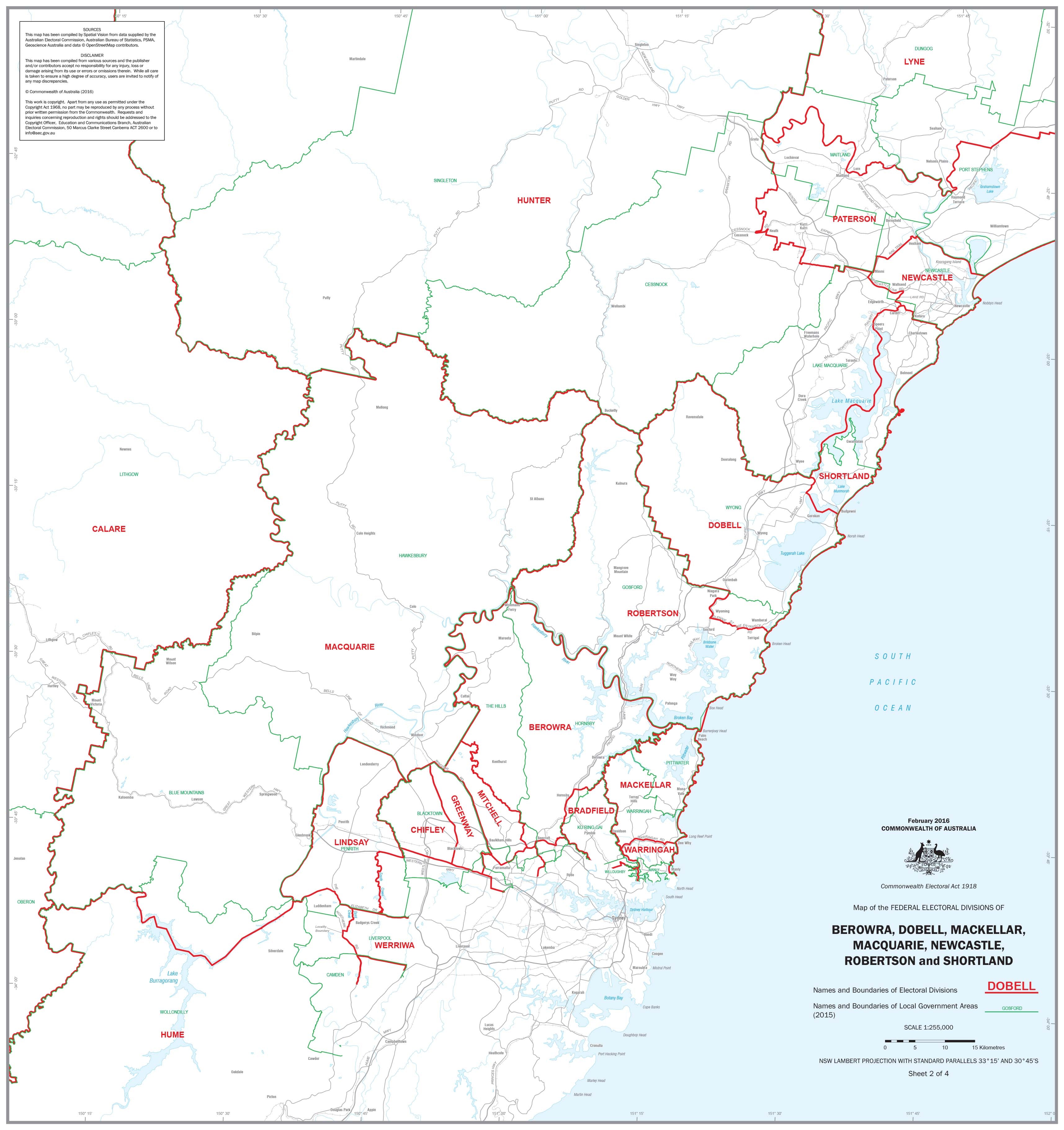
New South Wales Federal Electoral Divisions and Local Government Areas Map - Newcastle & Area
$59.95
or make 4 interest-free payments of
$14.99 AUD
fortnightly with
![]() More info
More info
This professionally crafted wall map offers a comprehensive overview of the federal electoral divisions and local government areas (LGAs) within the Newcastle region of New South Wales. Ideal for educators, political analysts, civic planners, and engaged citizens, it provides a clear visual representation of the region's political and administrative boundaries.
🗺️ Detailed Coverage
The map encompasses the following federal electoral divisions:
-
Berowra
-
Dobell
-
Mackellar
-
Macquarie
-
Newcastle
-
Robertson
-
Shortland
Each division is clearly delineated, with boundaries and names accurately depicted. Additionally, the map outlines the corresponding local government areas, providing a comprehensive view of the region's administrative divisions.
📐 Map Specifications
-
Dimensions: 700 mm (width) x 740 mm (height)
-
Content: Federal electoral division boundaries and names, local government area boundaries and names
-
Format: Printed map suitable for wall display
🖨️ Available Formats
1. Heavyweight Paper Version
-
Material: 160gsm premium matte paper
-
Ideal For: Framing under glass
-
Features: Smooth finish, vibrant colors, and a classic presentation
2. Laminated Version
-
Material: Encapsulated between two layers of 80-micron gloss laminate
-
Ideal For: High-traffic areas or educational settings
-
Features: Enhanced durability, tear and stain resistance, and easy maintenance
3. Matte Canvas Version
-
Material: 395gsm HP Professional Matte Canvas with pigment-based inks
-
Ideal For: Gallery-style display
-
Features: Fade-resistant, exceptional clarity, and a luxurious texture
🖼️ Elegant Display with Wooden Hang Rails
For the canvas version, enhance your map's presentation with lacquered wooden hang rails at the top and bottom, featuring a hanging cord for easy wall mounting. This option offers a clean, professional look and simplifies the hanging process.
Note: Please allow up to 10 working days for delivery of canvas maps with hang rails, as they require assembly by our professional framer.
🛠️ Customization Options
For those requiring more focused information, individual detailed maps of each electoral division can be produced upon request. This customization is ideal for targeted studies, presentations, or localized planning needs. To inquire about custom maps, please contact us directly.
This map serves as an invaluable resource for understanding the political and administrative landscape of Newcastle and its environs. Whether for educational purposes, civic planning, or personal interest, it provides a clear and detailed overview of the region's divisions.
Frequently Asked Questions
Where can I buy the New South Wales Federal Electoral Divisions and Local Government Areas?
The New South Wales Federal Electoral Divisions and Local Government Areas is available to buy online from Mapworld, Australia's largest map and geographic product retailer, with fast shipping Australia-wide.
Is the New South Wales Federal Electoral Divisions and Local Government Areas in stock at Mapworld?
Mapworld maintains extensive stock across its map range and aims for fast dispatch. Orders placed before 2pm AEST on business days are typically dispatched the same day, with standard and express Australia-wide delivery options available.
What is Mapworld's returns policy?
Mapworld accepts returns on undamaged items in original condition. Contact Mapworld within 90 days of purchase to arrange a return or exchange.
Does Mapworld ship the New South Wales Federal Electoral Divisions and Local Government Areas across Australia?
Yes, Mapworld ships Australia-wide. Standard shipping is a flat $7 rate, with free standard shipping on orders over $75. Express options are available at checkout. Most orders placed before 2pm AEST on weekdays are dispatched same day.
Related Items

© 2026 Mapworld. Website designed by Genie Media
X