

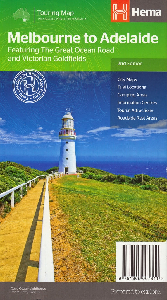
The ultimate road trip companion for discovering the stunning routes, scenic coasts, and regional highlights between two of Australia’s greatest cities.
Whether you’re hugging the dramatic limestone cliffs of the Great Ocean Road, winding through the Grampians, or taking a more direct inland drive through Ballarat, Horsham, or Bordertown, the Melbourne to Adelaide Touring Map by Hema provides everything you need to plan and enjoy a safe, scenic, and unforgettable journey.
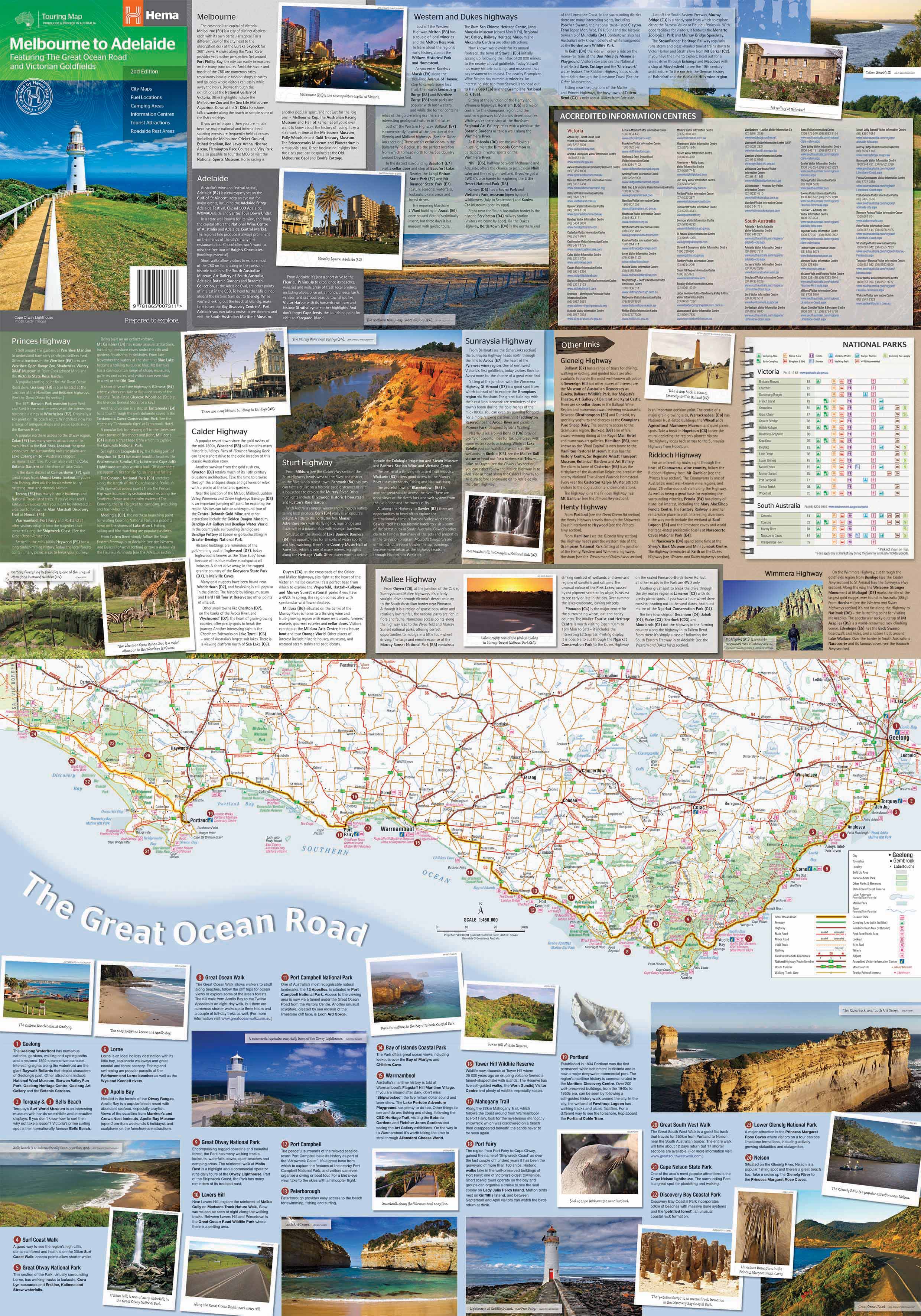
This double-sided touring map is designed for self-guided travellers, road trippers, caravanners, and holidaymakers who want to explore the heart of south-eastern Australia in detail. With clear mapping, tourist symbols, and practical navigation aids, it covers both the coastal route and the inland highway, highlighting rest stops, attractions, and accommodation options along the way.
🗺️ What’s on the Map?
📌 Main Route Coverage
-
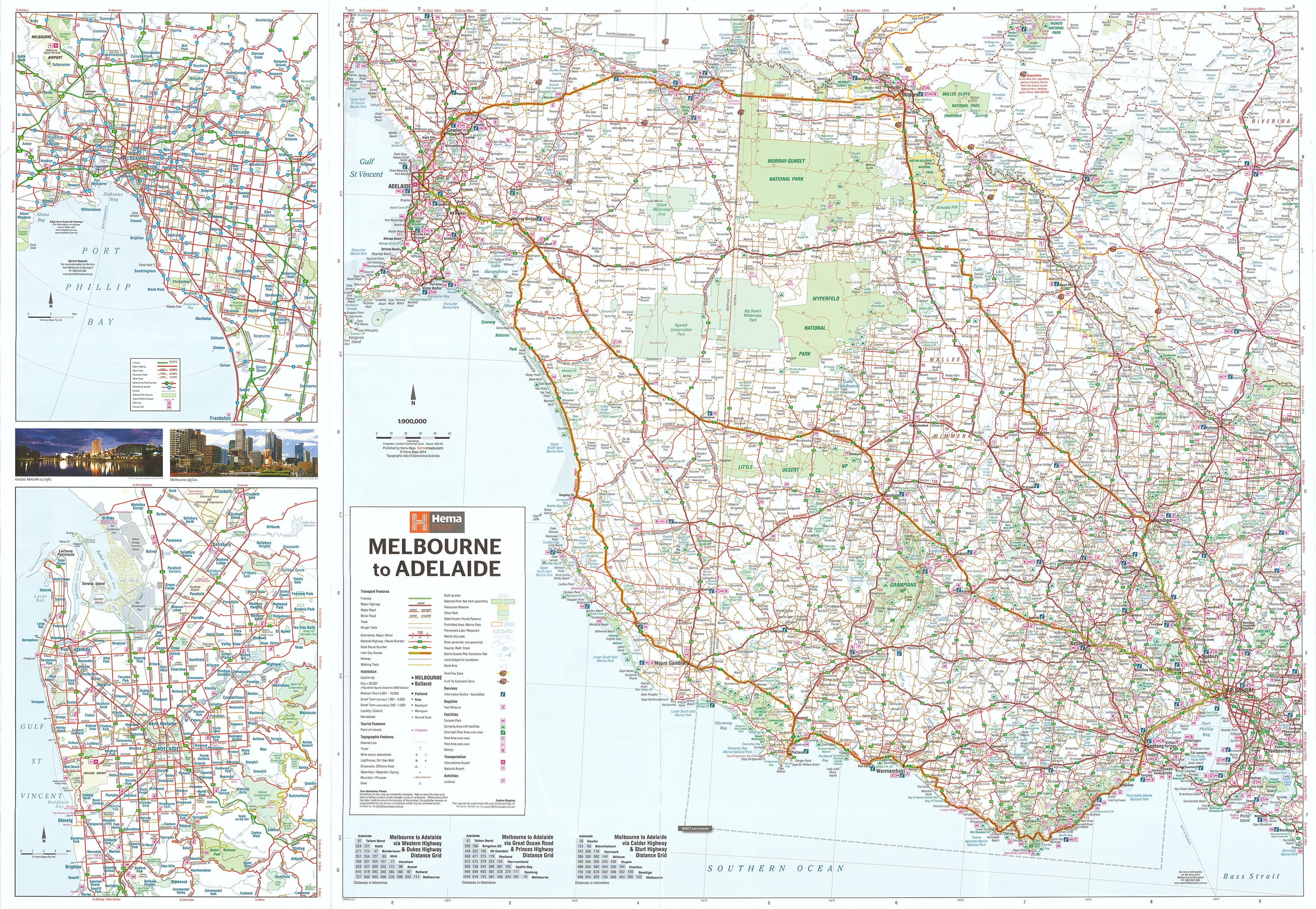
Full-colour topographic map at 1:900,000 scale
-
Covers both the coastal route via Torquay, Apollo Bay, Warrnambool, Port Fairy, Portland, and Mount Gambier, and the inland route via Geelong, Ballarat, Ararat, Horsham, Naracoorte, and Murray Bridge
-
Map includes key travel infrastructure such as highways, sealed and unsealed roads, railways, ferry routes, and local connectors
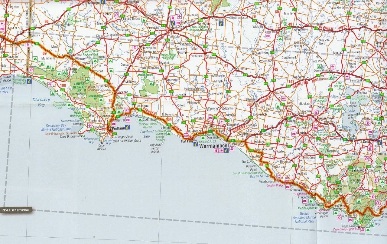
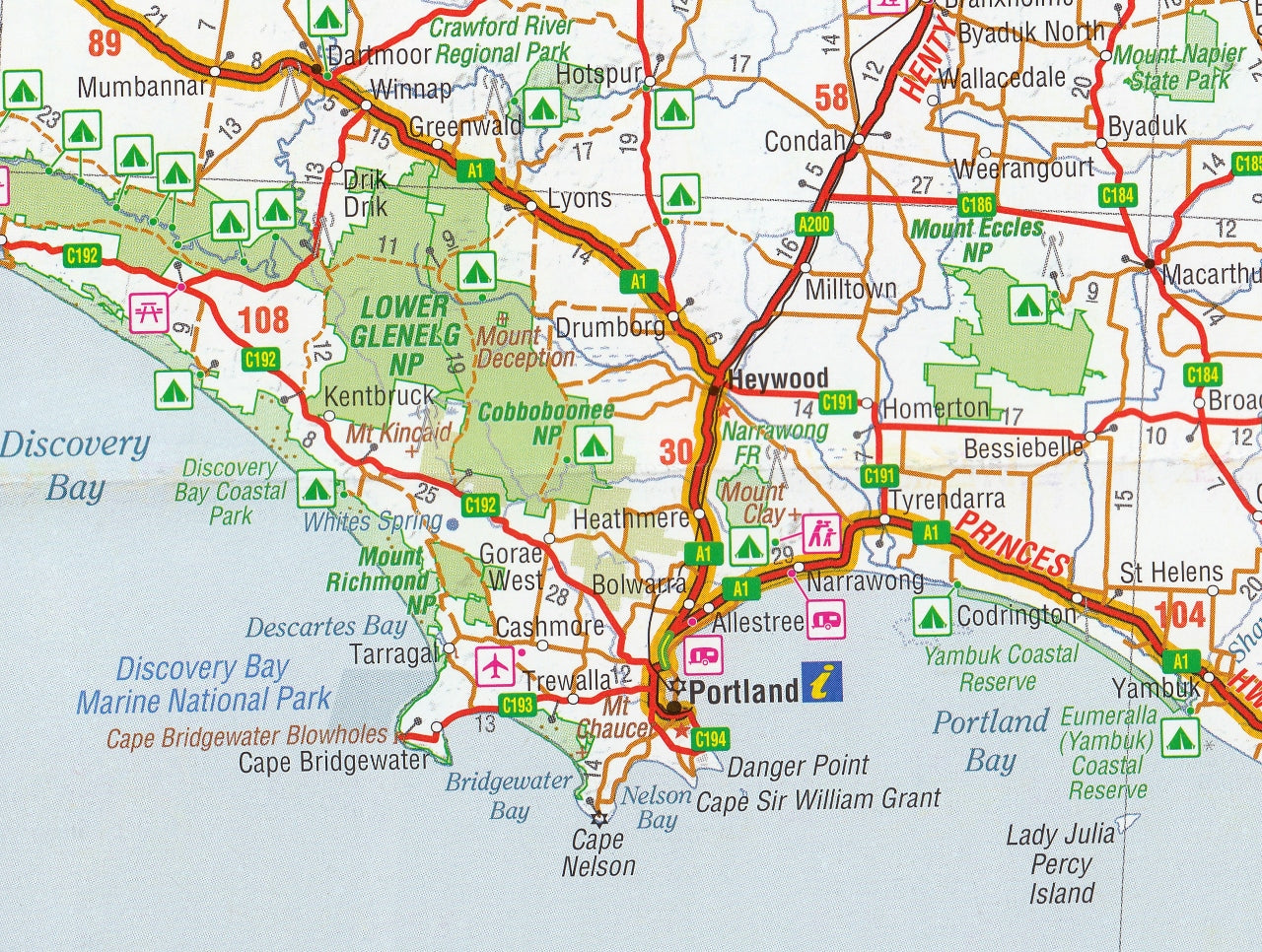
🏞️ Great Ocean Road Inset Map
-
Detailed inset map at 1:450,000 scale
-
Focuses on one of Australia’s most iconic road trips, highlighting:
-
Twelve Apostles, Loch Ard Gorge, Cape Otway, and London Arch
-
Camping areas, tourist information centres, national parks, and scenic lookouts
-
Small townships like Lorne, Port Campbell, and Anglesea
-
🏙️ Urban Area Detail
-
Detailed through-road maps of both Melbourne and Adelaide city centres
-
Helps drivers navigate urban traffic, major arterials, bypasses, and ring roads
📍 Travel Features & Navigation Tools
-
Tourist symbols mark:
-
National parks and nature reserves
-
Lookouts, museums, historical landmarks, and wineries
-
Fuel stops (including 24-hour stations), dump points, and roadside amenities
-
Accommodation options including caravan parks and campgrounds
-
-
Rest area symbols for fatigue management and planning breaks
-
Distance grid and driving times between major towns and cities
-
Elevation shading and terrain features to help visualise the landscape
📐 Map Specifications
-
Edition: 2nd Edition
-
Main Map Scale: 1:900,000
-
Inset Scale (Great Ocean Road): 1:450,000
-
Flat Size: 700 mm (W) × 1000 mm (H)
-
Folded Size: 140 mm × 250 mm – compact and glovebox-friendly
-
ISBN: 9781865007311
-
Printed on: High-quality matte-coated paper
-
Publisher: Hema Maps – Australia’s most trusted adventure mapping company
🛍️ Purchase Options
-
Standard Paper Map – $14.95 AUD
-
Ideal for folding and taking on the road
-
Lightweight and easy to pack
-
-
Laminated Version – Approx. $45.00 AUD
-
Waterproof, tear-resistant, and writable
-
Great for multiple uses and ideal for use with whiteboard markers or Map Dots
-
Perfect for dashboards, trip planning areas, or wall display in caravans or offices
-
🎯 Who Is This Map For?
-
Self-drive tourists & road-trippers planning a multi-day route
-
Caravan & campervan travellers navigating regional campsites and dump points
-
Families & first-time travellers looking for a scenic and user-friendly map
-
Overseas visitors wanting to explore Australia's southern touring routes
-
Locals discovering hidden gems between Victoria and South Australia
-
Event organisers, educators, and tour operators offering regional insight
🌟 Highlights Along the Way
-
The Great Ocean Road – Australia’s most scenic coastal drive
-
Otway National Park – lush rainforests and waterfalls
-
Tower Hill & Mt Eccles – dormant volcanoes and Aboriginal heritage
-
The Grampians (Gariwerd) – sandstone peaks, Aboriginal rock art, and wildlife
-
Naracoorte Caves – World Heritage fossil site
-
Fleurieu Peninsula and Murray River – a taste of regional South Australia
-
Vineyards and cellar doors in Coonawarra and Langhorne Creek
🚗 Why Choose the Hema Melbourne to Adelaide Map?
-
Offers more route context than GPS alone
-
Emphasises touring experience, not just directions
-
Covers practical travel info (fuel, rest stops, distances) at a glance
-
Ideal for planning in advance or adjusting en route
-
Printed by Hema Maps, renowned for field-verified cartography and outback navigation accuracy
Whether you're planning a coastal odyssey along the Great Ocean Road or a direct dash via the Western Highway, the Hema Melbourne to Adelaide Map ensures you do it with confidence, clarity, and all the best information at your fingertips.
Unfold the adventure. One map. Two cities. Infinite discoveries.


