- Australia ▾
- Topographic
▾
- Australia AUSTopo 250k (2025)
- Australia 50k Geoscience maps
- Australia 100k Geoscience maps
- Australia 250k Geoscience maps
- Australia 1:1m Geoscience maps
- New Zealand 50k maps
- New Zealand 250k maps
- New South Wales 25k maps
- New South Wales 50k maps
- New South Wales 100k maps
- Queensland 10k maps
- Queensland 25k maps
- Queensland 50k maps
- Queensland 100k maps
- Western Australia 25k maps
- Western Australia 50k maps
- Western Australia 100k maps
- Compasses
- Software
- GPS Systems
- International ▾
- Wall Maps
▾
- World
- Australia & New Zealand
- Countries, Continents & Regions
- Historical
- Vintage National Geographic
- Australian Capital Territory
- New South Wales
- Northern Territory
- Queensland
- South Australia
- Tasmania
- Victoria
- Western Australia
- Celestial
- Children's
- Mining & Resources
- Wine Maps
- Healthcare
- Postcode Maps
- Electoral Maps
- Nautical ▾
- Flags
▾
- Australian Flag Sets & Banners
- Flag Bunting
- Handwavers
- Australian National Flags
- Aboriginal Flags
- Torres Strait Islander Flags
- International Flags
- Flagpoles & Accessories
- Australian Capital Territory Flags
- New South Wales Flags
- Northern Territory Flags
- Queensland Flags
- South Australia Flags
- Tasmania Flags
- Victoria Flags
- Western Australia Flags
- Gifts ▾
- Globes ▾
Dear valued customer. Please note that our checkout is not supported by old browsers. Please use a recent browser to access all checkout capabilities


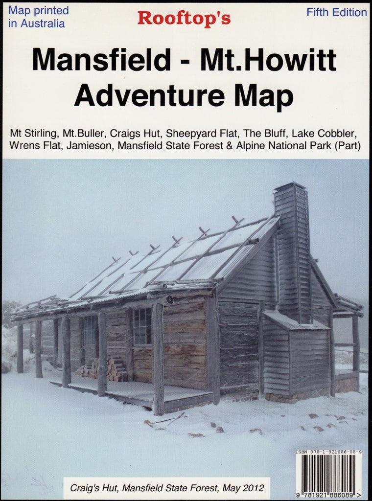
Mansfield - Mt.Howitt Adventure Map Rooftop
$9.95 $11.95
Afterpay is only available for orders between $50.00 and $1000.00 More info
Your Essential Companion to Victoria’s Alpine High Country
Whether you’re planning an off-road escape, a high-country hike, or a weekend of camping in the Victorian Alps, the Mansfield – Mt Howitt Adventure Map delivers detailed, reliable topographic information to guide you every step of the way. Created by Rooftop Maps, Australia's most trusted name in regional mapping, this double-sided map covers one of the most spectacular and historically rich wilderness areas in the state.
From the iconic Craig’s Hut (made famous by The Man from Snowy River) to the secluded beauty of Sheepyard Flat, this map provides accurate, GPS-mapped information for serious explorers and leisure travellers alike.
🌄 What This Map Covers:
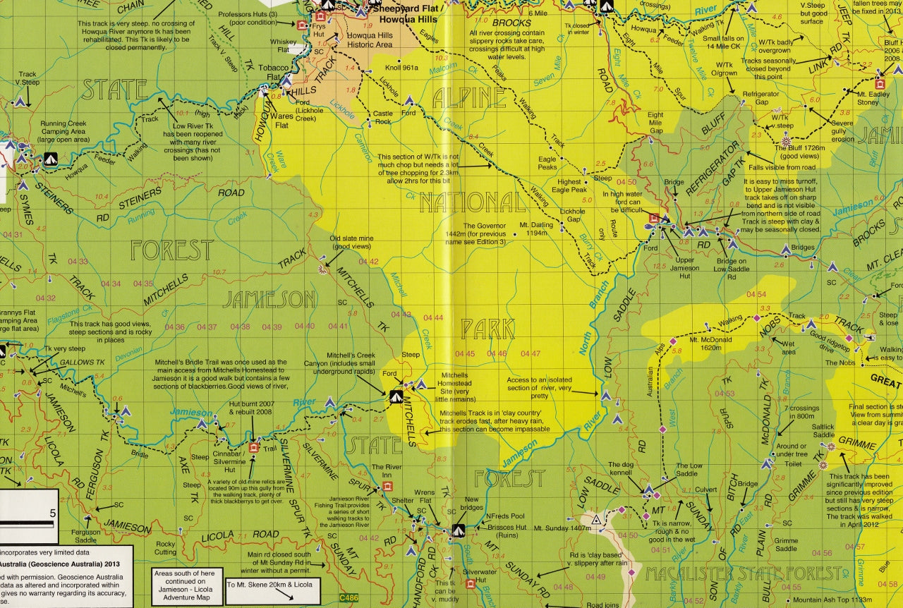
The Mansfield – Mt Howitt map covers a wide and varied region in the Victorian High Country, including:
-
Mt Stirling & Mt Buller – Popular for snow sports and alpine trails
-
Craig’s Hut & The Bluff – Iconic viewpoints and 4WD destinations
-
Sheepyard Flat & Wrens Flat – Scenic camping and fishing areas along the Howqua River
-
Jamieson & Lake Cobbler – Serene lakeside recreation areas
-
Mansfield State Forest & Alpine National Park – Forests, peaks, ridges, and remote bushland
You’ll also find detailed inset maps of:
-
🗺️ Mansfield Township – Great for last-minute supply runs or accommodation
-
🌲 Sheepyard Flat – Craig’s Hut Forest Activities Map – Highlights access points, trails, and forest roads between these two popular hubs
🧭 Key Map Features:
-
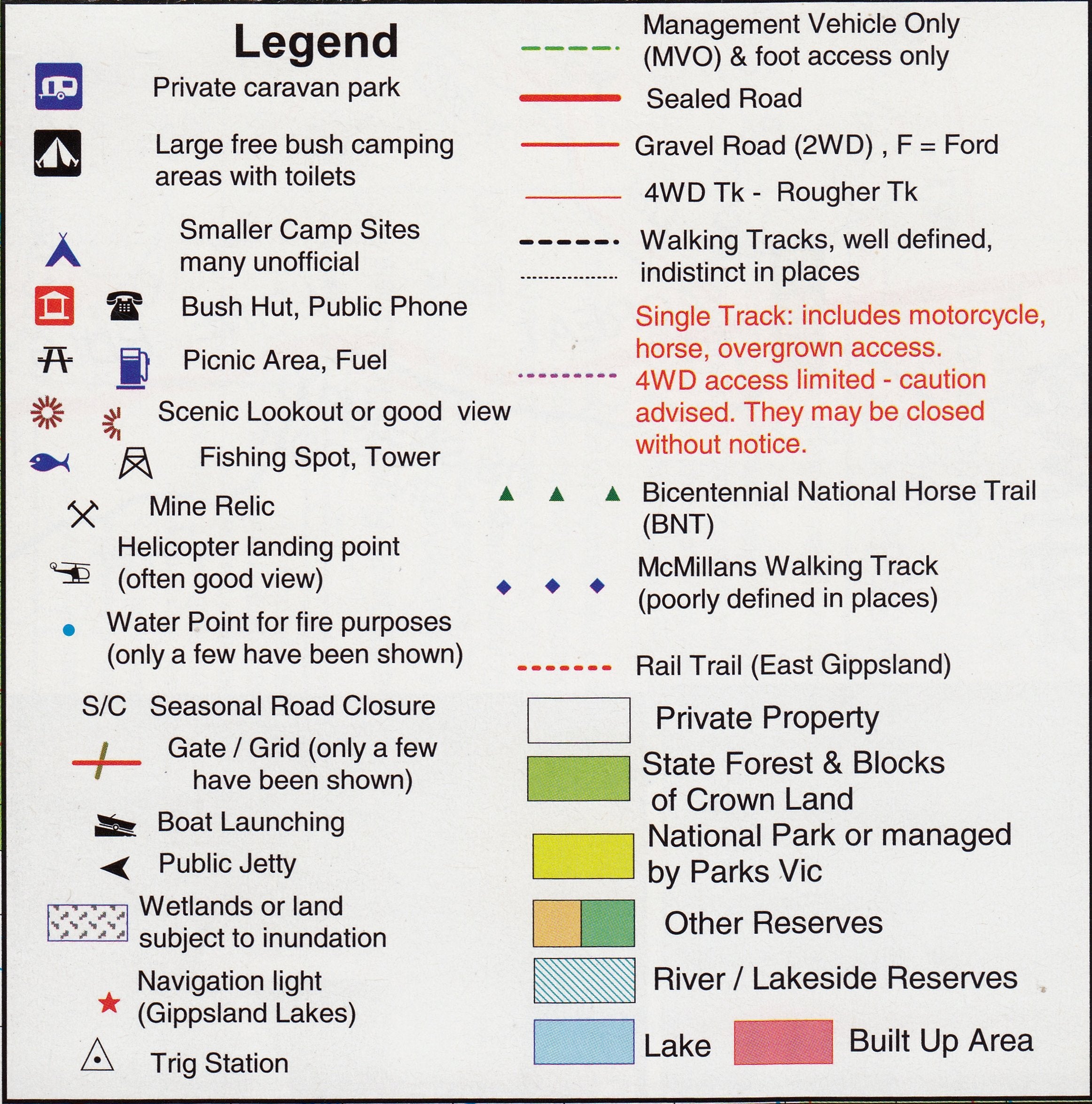
🛣️ Track Classifications
All roads, trails, and 4WD tracks are clearly classified, showing surface type and accessibility (including seasonal closures). -
⛺ Camping & Facilities
Clear symbology indicates available facilities like toilets, picnic tables, campgrounds, huts, trailheads, and lookouts. -
🎣 Fishing Spots
Fishing-friendly creeks and rivers are marked, perfect for anglers targeting trout and native species. -
📍 GPS-Compatible
The map is grid-referenced and includes GPS-compatible coordinates, making it ideal for use with mobile apps or handheld GPS devices. -
🧱 Contour Shading & Elevation
Terrain is represented with hill shading and contour lines, allowing for accurate route planning in mountainous and valley terrain.
🖨️ Available Finishes:
📄 Standard Paper
-
High-resolution, full-colour printing on durable mapping paper
-
Ideal for planning trips at home or displaying in cabins or offices
💧 Laminated (Encapsulated Gloss Finish)
-
Printed on quality paper, then encapsulated in 80-micron gloss laminate
-
Waterproof and tear-resistant – great for outdoor use in variable conditions
-
Writeable with whiteboard markers – annotate your route or log sightings
-
Apply reusable map dots to track favourite spots, hut visits, or campsite selections
🧼 Laminated maps are ideal for 4WD dashboards, camp planning tables, and reuse on multiple trips
📐 Map Specifications:
| Feature | Details |
|---|---|
| Scale | 1:100,000 (main) / 1:50,000 (inset detail) |
| Size | 700 mm (W) x 1000 mm (H) |
| Sheet Type | Double-sided |
| Material | Standard paper or laminated finish |
| Publisher | Rooftop Maps |
| Edition | Latest available print edition |
🧭 Perfect For:
-
🚙 4WD Touring Enthusiasts – Navigate the high plains and forest trails with clarity
-
🥾 Bushwalkers & Hikers – Plan summit routes and long-range treks with detailed terrain data
-
⛺ Campers & Caravanners – Discover all the best campsites from riverside nooks to alpine clearings
-
🎣 Fishermen – Pinpoint remote streams and lakes for trout fishing
-
📚 Outdoor Educators & Leaders – A field-tested tool for wilderness programs and bush safety
📦 Delivery & Packaging
-
All maps are carefully rolled and shipped in sturdy tubes
-
Laminated versions are made to order – please allow an additional 1–2 business days for processing
-
Express shipping available
🌲 Explore with Confidence
Whether you're camping under the stars at Howqua Hills, traversing the Bluff Track, or seeking the summit of Mt Stirling, the Mansfield – Mt Howitt Adventure Map gives you the tools to explore one of Australia’s most iconic alpine regions safely, confidently, and enjoyably.
Frequently Asked Questions
Where can I buy the Mansfield - Mt.Howitt Adventure Map Rooftop?
The Mansfield - Mt.Howitt Adventure Map Rooftop is available to buy online from Mapworld, Australia's largest map and geographic product retailer, with fast shipping Australia-wide.
Is the Mansfield - Mt.Howitt Adventure Map Rooftop in stock at Mapworld?
Mapworld maintains extensive stock across its map range and aims for fast dispatch. Orders placed before 2pm AEST on business days are typically dispatched the same day, with standard and express Australia-wide delivery options available.
What is Mapworld's returns policy?
Mapworld accepts returns on undamaged items in original condition. Contact Mapworld within 90 days of purchase to arrange a return or exchange.
Does Mapworld ship the Mansfield - Mt.Howitt Adventure Map Rooftop across Australia?
Yes, Mapworld ships Australia-wide. Standard shipping is a flat $7 rate, with free standard shipping on orders over $75. Express options are available at checkout. Most orders placed before 2pm AEST on weekdays are dispatched same day.
Related Items


© 2026 Mapworld. Website designed by Genie Media
X