- Australia ▾
- Topographic
▾
- Australia AUSTopo 250k (2024)
- Australia 50k Geoscience maps
- Australia 100k Geoscience maps
- Australia 250k Geoscience maps
- Australia 1.1m Geoscience maps
- New Zealand 50k maps
- New Zealand 250k maps
- New South Wales 25k maps
- New South Wales 50k maps
- New South Wales 100k maps
- Queensland 10k maps
- Queensland 25k maps
- Queensland 50k maps
- Queensland 100k maps
- Compasses
- Software
- GPS Systems
- Orienteering
- International ▾
- Wall Maps
▾
- World
- Australia & New Zealand
- Countries, Continents & Regions
- Historical
- Vintage National Geographic
- Australian Capital Territory
- New South Wales
- Northern Territory
- Queensland
- South Australia
- Tasmania
- Victoria
- Western Australia
- Celestial
- Children's
- Mining & Resources
- Wine Maps
- Healthcare
- Postcode Maps
- Electoral Maps
- Nautical ▾
- Flags
▾
- Australian Flag Sets & Banners
- Flag Bunting
- Handwavers
- Australian National Flags
- Aboriginal Flags
- Torres Strait Islander Flags
- International Flags
- Flagpoles & Accessories
- Australian Capital Territory Flags
- New South Wales Flags
- Northern Territory Flags
- Queensland Flags
- South Australia Flags
- Tasmania Flags
- Victoria Flags
- Western Australia Flags
- Gifts ▾
- Globes ▾
Dear valued customer. Please note that our checkout is not supported by old browsers. Please use a recent browser to access all checkout capabilities


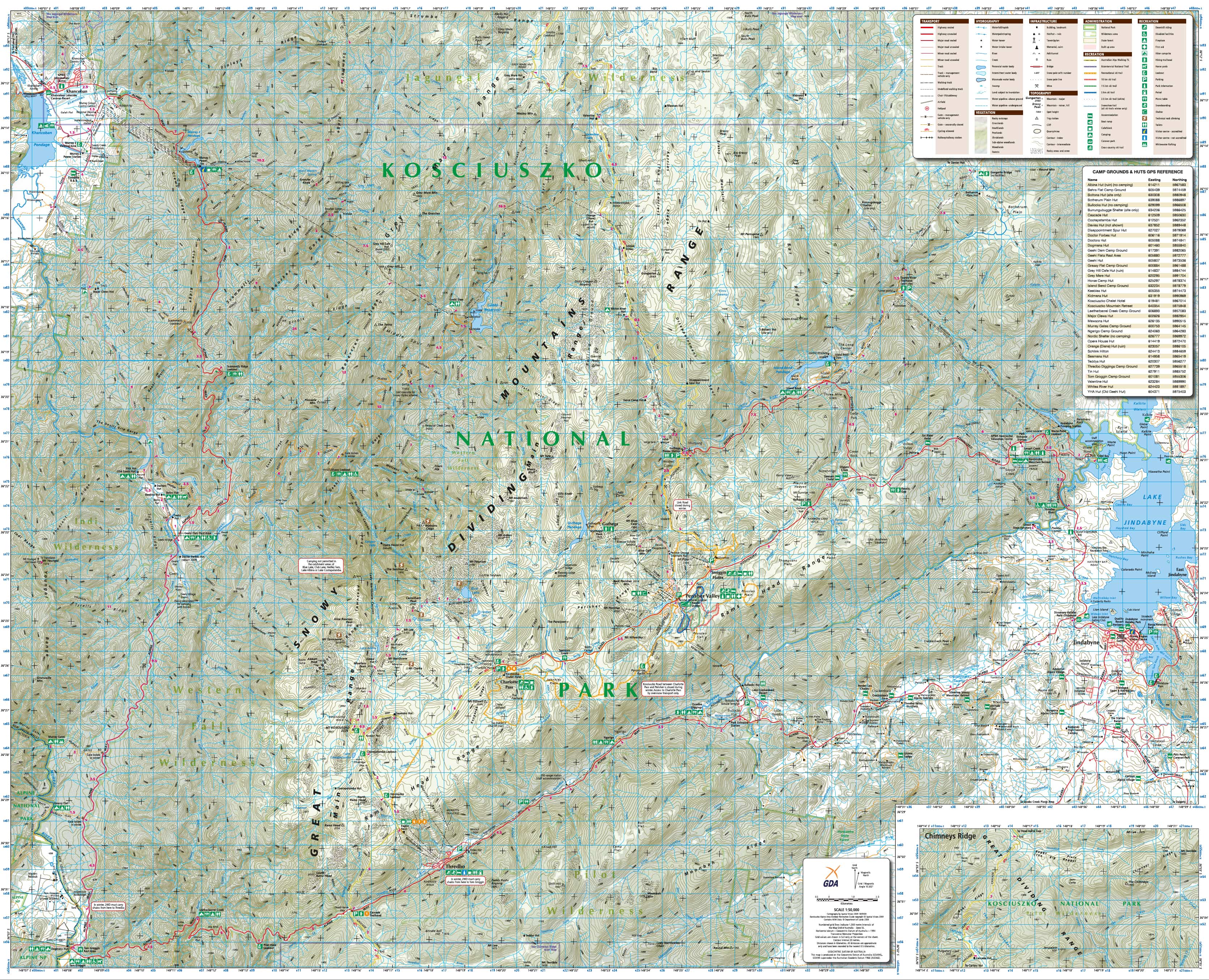
Kosciuszko Alpine Area (NSW) Topographic Wall Map by Spatial Vision
$69.95
or make 4 interest-free payments of
$17.49 AUD
fortnightly with
![]() More info
More info
🏔️ Kosciuszko Alpine Area (NSW) Topographic Wall Map – by Spatial Vision
Explore Australia's highest country with a detailed, field-ready topographic map.
The Kosciuszko Alpine Area Topographic Wall Map by Spatial Vision is the definitive navigation and recreation guide for Australia’s most elevated terrain. Whether you’re summiting Mount Kosciuszko, traversing the Main Range, cycling through alpine meadows, or navigating the trails around Thredbo and Charlotte Pass, this 1:50,000 scale map provides the detail and reliability essential for alpine adventurers.
This map is trusted by bushwalkers, mountain bikers, ski tourers, climbers, paddlers, and land managers alike — making it an indispensable tool for anyone exploring the Kosciuszko National Park and surrounding alpine highlands.
🧭 Key Features
-
Topographic Scale: 1:50,000 — optimal for high-detail route planning
-
20-metre contour intervals for accurate elevation and terrain reading
-
Walking trails, fire trails, ski touring routes, and mountain bike tracks
-
Alpine huts, backcountry campsites, lookout points, picnic areas
-
Lakes, rivers, alpine tarns, and catchment features
-
National park boundaries, roads, and 4WD access points
-
Accurate GDA94 coordinate grid with GPS referencing
-
Emergency locations, remote shelters, visitor facilities
With comprehensive trail networks and terrain data, this map supports confident, independent exploration in rugged alpine conditions.
🏞️ Regional Coverage
This map includes detailed coverage of key alpine regions within and around Kosciuszko National Park, including:
-
Mount Kosciuszko (Australia’s highest peak)
-
The Main Range & Sentinel Ridge
-
Thredbo, Charlotte Pass, and Perisher Valley
-
Blue Lake, Lake Albina, and surrounding glacial lakes
-
Geehi, Dead Horse Gap, and Guthega
-
Alpine Way and Snowy Mountains Highway corridors
-
High plains, subalpine woodlands, and glacial features
Perfect for multi-day trekking, ski touring, environmental fieldwork, or simply soaking in the beauty of Australia’s alpine wilderness.
📐 Product Specifications
| Feature | Detail |
|---|---|
| Title | Kosciuszko Alpine Area Topographic Map |
| Publisher | Spatial Vision |
| Scale | 1:50,000 |
| Size | 1000 mm (W) × 810 mm (H) |
| Contour Interval | 20 metres |
| Coordinate Grid | GDA94 Datum |
| Printed In | Australia |
📦 Available Formats
Choose the format that best suits your adventure style or display needs:
🧻 Standard Paper Edition
-
Crisp, high-resolution print on premium matte paper
-
Perfect for home, classroom, or professional office wall display
-
Also ideal for route planning or framing under glass
💧 Tyvek® Waterproof & Tear-Resistant Edition
-
Printed on DuPont™ Tyvek® – a flexible, foldable, ultra-durable synthetic material
-
Waterproof, tearproof, and built for use in snow, rain, or rugged terrain
-
Ideal for backcountry use where resilience matters most
✨ Laminated Edition
-
Fully encapsulated in 80-micron gloss laminate
-
Use whiteboard markers or apply removable map dots to plan routes or mark points of interest
-
Wipe-clean and resistant to stains, creasing, and moisture
🎯 Who Should Use This Map?
-
🥾 Hikers and trekkers traversing the Main Range or exploring alpine huts
-
🎿 Backcountry skiers and snowshoers navigating snowy terrain
-
🚵 Mountain bikers taking on high-altitude trails
-
🚙 Tourers and 4WD explorers accessing remote snowfields and campsites
-
📸 Photographers and ecologists studying alpine flora, glacial lakes, or weathered granite tors
-
🗺️ Educators and students in outdoor education and environmental sciences
🌟 Why Choose the Kosciuszko Alpine Area Map by Spatial Vision?
✔️ Australian-made, field-tested, and designed by professional cartographers
✔️ GPS-compatible with modern datum referencing
✔️ Available in rugged waterproof formats
✔️ Suitable for both recreational and professional use
✔️ Detailed enough to support emergency planning and wilderness navigation
📍 From snow-covered ridgelines to sparkling alpine lakes, the Kosciuszko Alpine Area offers some of the most breathtaking wilderness in Australia — and this map ensures you're well-equipped to explore it with confidence, precision, and safety.
Plan well. Navigate smart. Explore more.
With the Kosciuszko Alpine Area Topographic Wall Map, the summit is just the beginning.
