- Australia ▾
- Topographic
▾
- Australia AUSTopo 250k (2025)
- Australia 50k Geoscience maps
- Australia 100k Geoscience maps
- Australia 250k Geoscience maps
- Australia 1:1m Geoscience maps
- New Zealand 50k maps
- New Zealand 250k maps
- New South Wales 25k maps
- New South Wales 50k maps
- New South Wales 100k maps
- Queensland 10k maps
- Queensland 25k maps
- Queensland 50k maps
- Queensland 100k maps
- Western Australia 25k maps
- Western Australia 50k maps
- Western Australia 100k maps
- Compasses
- Software
- GPS Systems
- International ▾
- Wall Maps
▾
- World
- Australia & New Zealand
- Countries, Continents & Regions
- Historical
- Vintage National Geographic
- Australian Capital Territory
- New South Wales
- Northern Territory
- Queensland
- South Australia
- Tasmania
- Victoria
- Western Australia
- Celestial
- Children's
- Mining & Resources
- Wine Maps
- Healthcare
- Postcode Maps
- Electoral Maps
- Nautical ▾
- Flags
▾
- Australian Flag Sets & Banners
- Flag Bunting
- Handwavers
- Australian National Flags
- Aboriginal Flags
- Torres Strait Islander Flags
- International Flags
- Flagpoles & Accessories
- Australian Capital Territory Flags
- New South Wales Flags
- Northern Territory Flags
- Queensland Flags
- South Australia Flags
- Tasmania Flags
- Victoria Flags
- Western Australia Flags
- Gifts ▾
- Globes ▾
Dear valued customer. Please note that our checkout is not supported by old browsers. Please use a recent browser to access all checkout capabilities


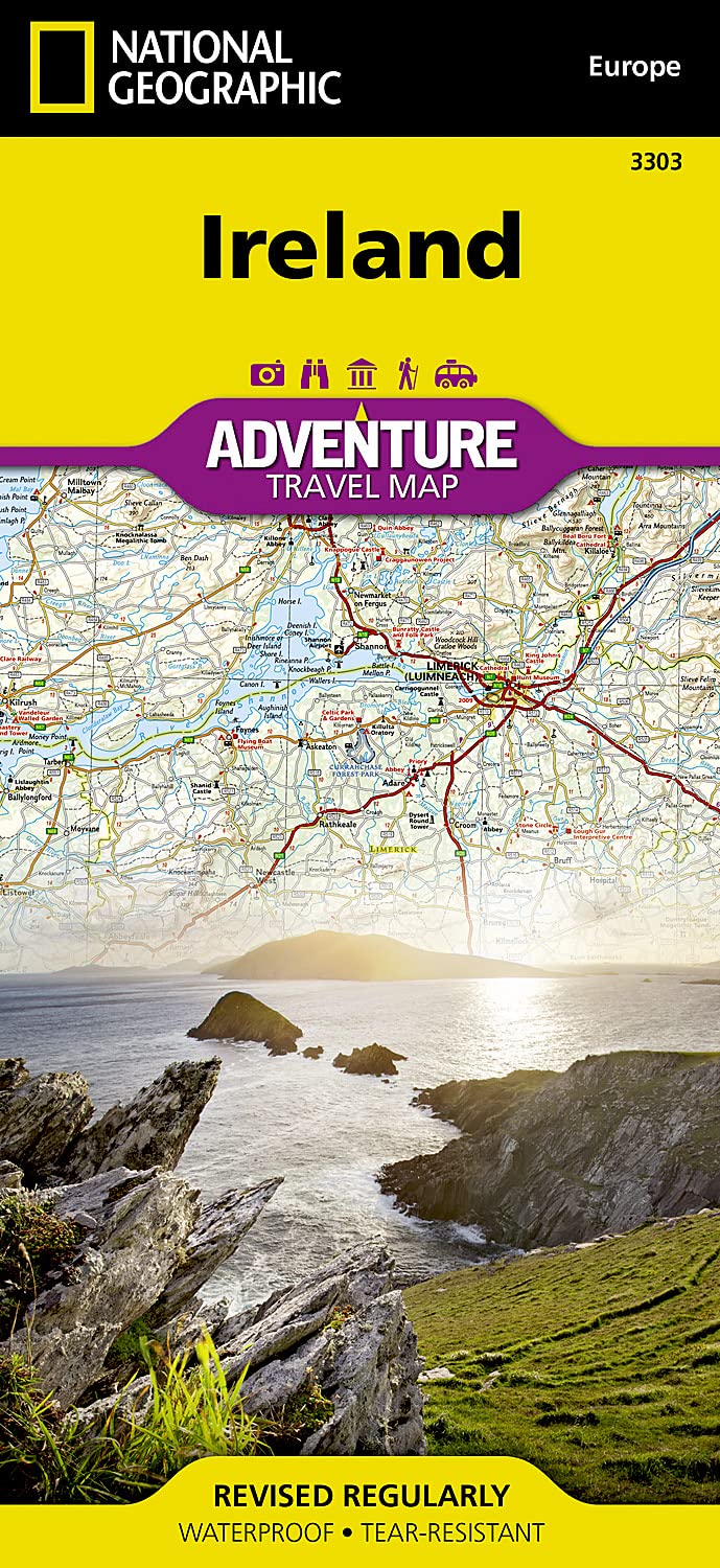

Ireland National Geographic Folded Map
$27.95
Afterpay is only available for orders between $50.00 and $1000.00 More info
🇮🇪 Ireland Adventure Map by National Geographic
Waterproof • Tear-Resistant • Detailed • Adventure-Ready
Scale 1:385,000 | Folded Travel Map
🧭 Your Ultimate Travel Companion for Exploring Ireland
Whether you're tracing the Wild Atlantic Way, hiking the Wicklow Mountains, or delving into centuries of history in Dublin and Galway, the Ireland Adventure Map by National Geographic is your trusted guide. Designed for the adventure traveler, this expertly researched map offers a unique combination of durability, accuracy, and depth, helping you uncover Ireland’s most iconic destinations and hidden gems alike.
Printed on synthetic waterproof paper, this map is built to withstand Ireland’s ever-changing weather and rugged conditions — perfect for life on the road, trail, or ferry.
🗺️ What the Map Covers
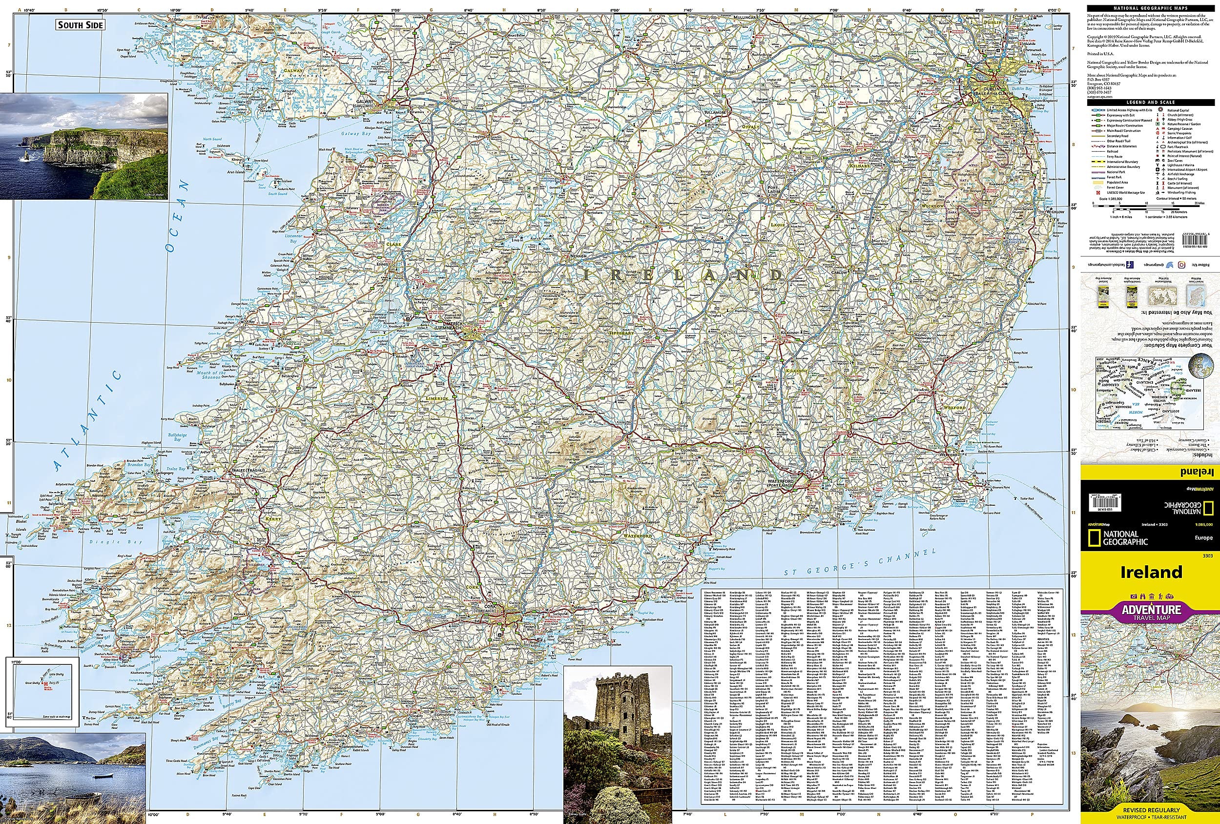
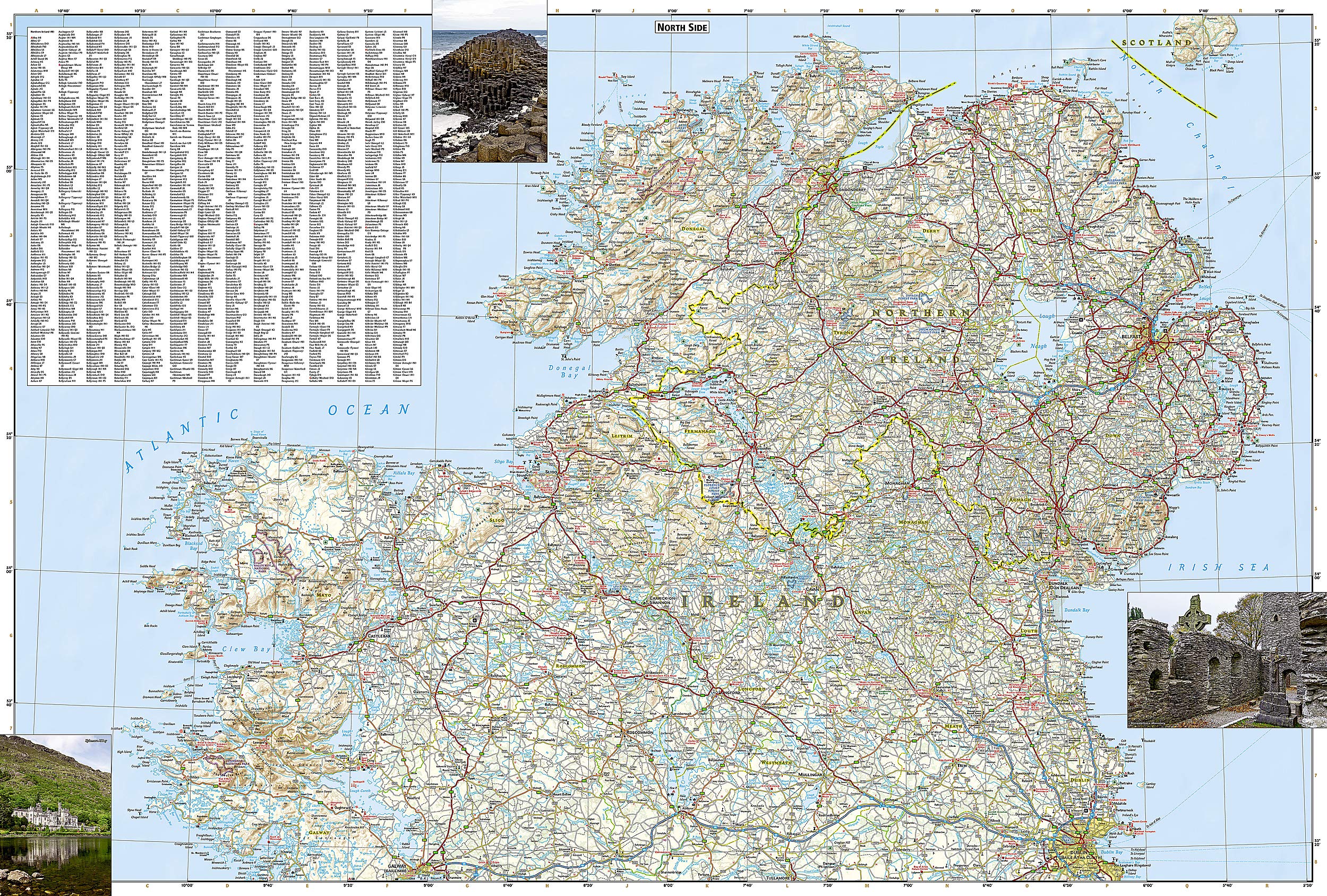
This two-sided map provides complete top-to-bottom coverage of the Republic of Ireland and Northern Ireland, with a clear overlap around Galway and Dublin to ensure seamless travel planning.
🧭 Side One: Northern Ireland & Northern Republic
-
From Malin Head (Ireland’s northernmost point) to Dublin and Galway
-
Includes: Belfast, Londonderry, Sligo, Dundalk, Armagh, Letterkenny
🧭 Side Two: Southern Ireland
-
From Galway and Dublin southwards to Cork, Limerick, Tralee, Killarney, and Waterford
-
Explores: The Ring of Kerry, Beara Peninsula, Cliffs of Moher, and Irish South Coast
🏞️ Adventure-Focused Features
| Feature | Description |
|---|---|
| 🛣️ Road Network | Highways, main roads, rural tracks & scenic routes with distance markers |
| 🧭 Topographic Shading | Terrain clearly represented with shaded relief |
| 🏕️ Outdoor Recreation Points | Hiking trails, campsites, scenic viewpoints, and nature reserves |
| 🏛️ Cultural Landmarks | Castles, ruins, UNESCO sites, and religious heritage locations |
| 🛶 Ferry Routes & Ports | Inter-island and international ferry connections marked |
| 🗺️ Tourist Attractions | Highlights include Cliffs of Moher, Giant’s Causeway, and Blarney Castle |
| 🏞️ National Parks | Glenveagh, Killarney, Wicklow Mountains, Burren, and others |
| 🏙️ City & Town Index | Find locations quickly with an alphabetical place name index |
| 🌦️ Weather-Proof Material | Printed on waterproof and tear-resistant synthetic paper |
| 🔍 Easy to Fold | Folds down to pocket-size for field or backpack use |
📐 Map Specifications
| Specification | Details |
|---|---|
| Map Scale | 1:385,000 |
| Map Size (unfolded) | 965 x 660 mm (38 x 26 in) |
| Folded Size | 235 x 108 mm (9.25 x 4.25 in) |
| Material | Synthetic waterproof paper |
| Printed | Double-sided |
| Brand | National Geographic |
🌍 Who This Map Is For
✅ Road Trippers planning a cross-country journey
✅ Hikers & Walkers exploring national parks and coastal trails
✅ Cultural Travellers visiting castles, abbeys, and heritage towns
✅ Photographers seeking out epic coastal landscapes and hidden gems
✅ Backpackers & Adventure Seekers who need a weatherproof, reliable guide
🧡 Why Choose a National Geographic Adventure Map?
-
Backed by National Geographic’s expertise in cartography and exploration
-
Superior map accuracy and specialist content you won’t find on standard tourist maps
-
Built for field use, whether you're navigating misty hillsides or planning your next leg in a cozy pub
→ Discover the real Ireland — one winding lane, misty hill, and stone cottage at a time. With this map in your hand, the road less travelled becomes the road most remembered.
🛒 Add to cart now and take your adventure to the next level.
Frequently Asked Questions
What area does the Ireland National Geographic Folded Map cover?
The Ireland National Geographic Folded Map provides road coverage of the region named in the product title. The map covers major cities, highways, towns, and regional roads, with inset city maps for key urban centres where applicable.
Is the Ireland National Geographic Folded Map up to date?
Yes, this is the current edition. Mapworld stocks the most current editions from all major publishers, updated to reflect new roads and infrastructure.
What size is this map when unfolded?
Folded maps from Mapworld's range are compact and portable. Most standard folded road or travel maps open to between A1 (594 × 841mm) and A0 (841 × 1189mm) when fully unfolded, and fold down to approximately A4 or smaller for easy storage in a glove box, bag, or backpack.
Is the Ireland National Geographic Folded Map in stock at Mapworld?
Mapworld maintains extensive stock across its map range and aims for fast dispatch. Orders placed before 2pm AEST on business days are typically dispatched the same day, with standard and express Australia-wide delivery options available.
Does Mapworld ship the Ireland National Geographic Folded Map across Australia?
Yes, Mapworld ships Australia-wide. Standard shipping is a flat $7 rate, with free standard shipping on orders over $75. Express options are available at checkout. Most orders placed before 2pm AEST on weekdays are dispatched same day.
Related Items


© 2026 Mapworld. Website designed by Genie Media
X