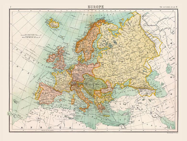
Europe on the Brink — Historic Wall Map (1898)
Witness a continent poised for upheaval. First published in 1898 for The Citizen’s Atlas—engraved by John Bartholomew & Co. for Collins—this full-colour wall map captures Europe before the First World War redrew its borders. The Austro-Hungarian Empire, the German Empire, and the Russian Empire command the page; international frontiers are crisply marked; countries appear in alternating colours for instant legibility. Oceans, rivers, mountain ranges and shipping routes complete a portrait of power, trade and terrain on the eve of the twentieth century.
More Than a Map – A Testament to History
This is not just wall art—it’s a window into the diplomatic and geographic reality that would soon be transformed by war. Every boundary line, place name and shipping lane speaks to alliances, ambitions and the currents of industry and empire. Ideal for historians, educators, collectors, designers, or anyone with family ties to Europe, this map invites study, discussion and context.
Display it in classrooms, offices, museums, libraries—or at home—to create a space for reflection and learning.
Premium Materials & Finishes
We treat history with the respect it deserves. Choose from premium formats produced with archival methods for beauty that lasts.
🌟 Archival Paper Print
Printed on heavyweight 160gsm archival-grade paper.
Smooth matte finish reduces glare and preserves delicate engraved detail—perfect for framing under glass.
💎 Laminated Edition
Encapsulated in two 80-micron gloss laminate sheets using true thermal bonding.
Moisture-resistant, wipe-clean surface—ideal for schools, offices and high-traffic spaces.
Optional Natural Timber Hang Rails: lacquered rails with a fitted cord offer a polished, ready-to-hang presentation. (Please allow up to 10 working days for delivery with hang rails.)
🏆 Museum-Quality Canvas
Printed on 395gsm HP Professional Matte Canvas for rich texture and strength.
Pigment-based, fade-resistant inks deliver vibrant colour and crisp lines built to endure.
Optional Natural Timber Hang Rails: lacquered to enhance the grain, with a top cord for effortless hanging—timeless and elegant. (Please allow up to 10 working days for delivery with hang rails.)
Specifications
| Feature | Details |
|---|---|
| Original Publication | 1898, The Citizen’s Atlas |
| Publisher/Engraver | John Bartholomew & Co. for Collins |
| Title | Historic Map of Europe (1898) |
| Content Highlights | Pre-WWI borders; countries in alternating colours; oceans, rivers, mountain ranges & shipping routes |
| Map Size | 816 mm (W) × 624 mm (H) |
| Available Formats | Paper, Laminated, Canvas |
| Paper Weight | 160gsm archival-quality |
| Laminate | 2 × 80-micron gloss laminate sheets (encapsulated) |
| Canvas Weight | 395gsm HP Professional Matte Canvas |
| Inks | Pigment-based, fade-resistant |
| Optional Hang Rails | Available on Laminated & Canvas versions |
| Origin | Made in Australia |
Why Choose This Map
✔ A Pre-War Snapshot: See Europe’s political geography before the seismic changes of 1914–1918.
✔ Atlas Pedigree: From Collins and John Bartholomew & Co., masters of late-Victorian cartography.
✔ Immediate Clarity: Alternating country colours and crisp frontiers make complex history easy to read.
✔ Crafted to Last: Premium substrates and archival inks preserve detail and colour for decades.
✔ Ready to Display: Optional hang-railed laminated or canvas editions provide a museum-quality look—no framing required.
✔ A Thoughtful Gift: Mark an anniversary, honour family heritage, or enrich a learning space with a true historical statement piece.
Our Commitment
We believe preserving history is as important as telling it. Every map is printed locally in Australia using state-of-the-art technology, carefully checked by hand, and packed with care. From our workshop to your wall, we ensure quality you can trust and a legacy you’ll be proud to share.
Bring this pivotal European portrait into your space. Order the Historic Map of Europe (1898) today—a faithful record of a continent on the cusp of change.


