- Australia ▾
- Topographic
▾
- Australia AUSTopo 250k (2024)
- Australia 50k Geoscience maps
- Australia 100k Geoscience maps
- Australia 250k Geoscience maps
- Australia 1.1m Geoscience maps
- New Zealand 50k maps
- New Zealand 250k maps
- New South Wales 25k maps
- New South Wales 50k maps
- New South Wales 100k maps
- Queensland 10k maps
- Queensland 25k maps
- Queensland 50k maps
- Queensland 100k maps
- Compasses
- Software
- GPS Systems
- Orienteering
- International ▾
- Wall Maps
▾
- World
- Australia & New Zealand
- Countries, Continents & Regions
- Historical
- Vintage National Geographic
- Australian Capital Territory
- New South Wales
- Northern Territory
- Queensland
- South Australia
- Tasmania
- Victoria
- Western Australia
- Celestial
- Children's
- Mining & Resources
- Wine Maps
- Healthcare
- Postcode Maps
- Electoral Maps
- Nautical ▾
- Flags
▾
- Australian Flag Sets & Banners
- Flag Bunting
- Handwavers
- Australian National Flags
- Aboriginal Flags
- Torres Strait Islander Flags
- International Flags
- Flagpoles & Accessories
- Australian Capital Territory Flags
- New South Wales Flags
- Northern Territory Flags
- Queensland Flags
- South Australia Flags
- Tasmania Flags
- Victoria Flags
- Western Australia Flags
- Gifts ▾
- Globes ▾
Dear valued customer. Please note that our checkout is not supported by old browsers. Please use a recent browser to access all checkout capabilities
Sydney & Region Hema 700 x 1000mm Laminated Wall Map
$99.00
or make 4 interest-free payments of
$24.75 AUD
fortnightly with
![]() More info
More info
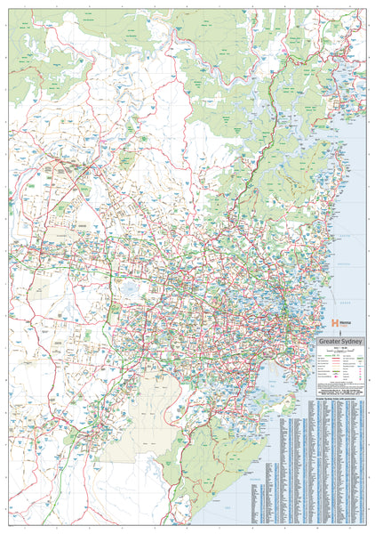
Greater Sydney Laminated Wall Map by Hema – A Clear and Durable Planning Tool
A large-format map of Greater Sydney ideal for logistics, planning, education, and reference — fully laminated and made in Australia for long-term use
The Greater Sydney Map by Hema is a high-quality, easy-to-read wall map that delivers an impressive level of detail across the entire Sydney metropolitan area. Extending from Gosford in the north, through Sydney CBD, down to Sutherland in the south, and stretching west to Penrith, it is one of the most comprehensive Sydney overviews available for display and strategic use.
Designed with both function and presentation in mind, this map features a clean, readable layout and clearly delineates major and minor roads, MetRoads, national and state route numbers, and the locations of existing and proposed freeway corridors. It also includes postcode boundaries, making it especially useful for delivery zones, franchise planning, sales territory mapping, and business development.
🗺️ Map Coverage & Features
-
Full coverage of Greater Sydney, including:
-
Northern regions like Gosford, Hornsby, and Ryde
-
Southern suburbs down to Sutherland, Miranda, and Cronulla
-
Western growth areas such as Penrith, Blacktown, and Parramatta
-
Eastern sections including Sydney CBD, Eastern Suburbs, and Bondi
-
-
Displays:
-
All major highways, motorways, and arterial roads
-
MetRoad and route numbering systems
-
Present and planned freeway infrastructure
-
Suburb boundaries and full postcode areas
-
Key infrastructure such as rail lines, rivers, and major parks
-
🖨️ Superior Printing & Lamination
-
Printed on 120 gsm FSC-certified matte-coated paper
-
Uses fade-resistant, pigment-based Hewlett-Packard inks for crisp and vibrant printing
-
Fully laminated between two 80-micron gloss sheets, resulting in a durable, waterproof, and UV-resistant finish
This professional lamination allows:
-
Use of whiteboard markers for writing, planning, and wiping off notes
-
Application of Map Dots to track locations, routes, or business points
-
Long-term use in high-touch environments like offices, control rooms, classrooms, or delivery depots
📐 Specifications
-
Scale: 1:100,000 — detailed enough to see street layout and suburb structure, broad enough for regional overview
-
Size: 700 mm (W) x 1000 mm (H) — large enough to make an impact, compact enough for most walls
-
Orientation: Portrait
-
Edition: Latest available
-
Published by: Hema Maps
-
Made: Proudly printed and laminated in Australia
🛒 Purchase Options
-
Flat Laminated Map – $99.00
-
Supplied professionally laminated and perfectly flat
-
Suitable for framing, pinning, or direct wall hanging in offices or boardrooms
-
-
Laminated Folded Map – $49.95
-
A previously folded map that has been laminated
-
May show slight crease lines from its original format
-
Excellent for casual or mobile use in workshops, garages, or temporary setups
-
🧠 Who Uses This Map?
This Greater Sydney map is relied upon by:
-
Real estate offices for zoning, catchment areas, and service boundaries
-
Logistics and courier companies planning deliveries and driver territories
-
Franchise and retail networks defining market areas and coverage
-
Government departments and councils for infrastructure and spatial analysis
-
Educators and schools teaching geography, urban development, or demography
-
Remote workers and freelancers needing local reference points in home offices
-
Families and newcomers to Sydney seeking to learn the layout of their new city
✅ Why Choose Hema’s Greater Sydney Map?
-
Locally made with high environmental and quality standards
-
Produced by Hema Maps, Australia’s trusted mapping brand for decades
-
Combines cartographic accuracy, visual clarity, and practical format
-
Designed to be interactive, long-lasting, and suitable for real-world use
-
A smart, informative alternative (or backup) to digital navigation tools
🧭 A Tool for Navigation, Planning & Presentation
Whether you're routing vehicles, dividing sales territories, planning infrastructure, or simply exploring Sydney from your wall, the Greater Sydney Laminated Map by Hema is a dependable, high-clarity reference that brings structure to complexity.
Easy to use. Easy to read. Built to last.
From the Northern Beaches to the Blue Mountains, understand Sydney — one glance at a time.


