- Australia ▾
- Topographic
▾
- Australia AUSTopo 250k (2025)
- Australia 50k Geoscience maps
- Australia 100k Geoscience maps
- Australia 250k Geoscience maps
- Australia 1.1m Geoscience maps
- New Zealand 50k maps
- New Zealand 250k maps
- New South Wales 25k maps
- New South Wales 50k maps
- New South Wales 100k maps
- Queensland 10k maps
- Queensland 25k maps
- Queensland 50k maps
- Queensland 100k maps
- Compasses
- Software
- GPS Systems
- Orienteering
- International ▾
- Wall Maps
▾
- World
- Australia & New Zealand
- Countries, Continents & Regions
- Historical
- Vintage National Geographic
- Australian Capital Territory
- New South Wales
- Northern Territory
- Queensland
- South Australia
- Tasmania
- Victoria
- Western Australia
- Celestial
- Children's
- Mining & Resources
- Wine Maps
- Healthcare
- Postcode Maps
- Electoral Maps
- Nautical ▾
- Flags
▾
- Australian Flag Sets & Banners
- Flag Bunting
- Handwavers
- Australian National Flags
- Aboriginal Flags
- Torres Strait Islander Flags
- International Flags
- Flagpoles & Accessories
- Australian Capital Territory Flags
- New South Wales Flags
- Northern Territory Flags
- Queensland Flags
- South Australia Flags
- Tasmania Flags
- Victoria Flags
- Western Australia Flags
- Gifts ▾
- Globes ▾
Dear valued customer. Please note that our checkout is not supported by old browsers. Please use a recent browser to access all checkout capabilities


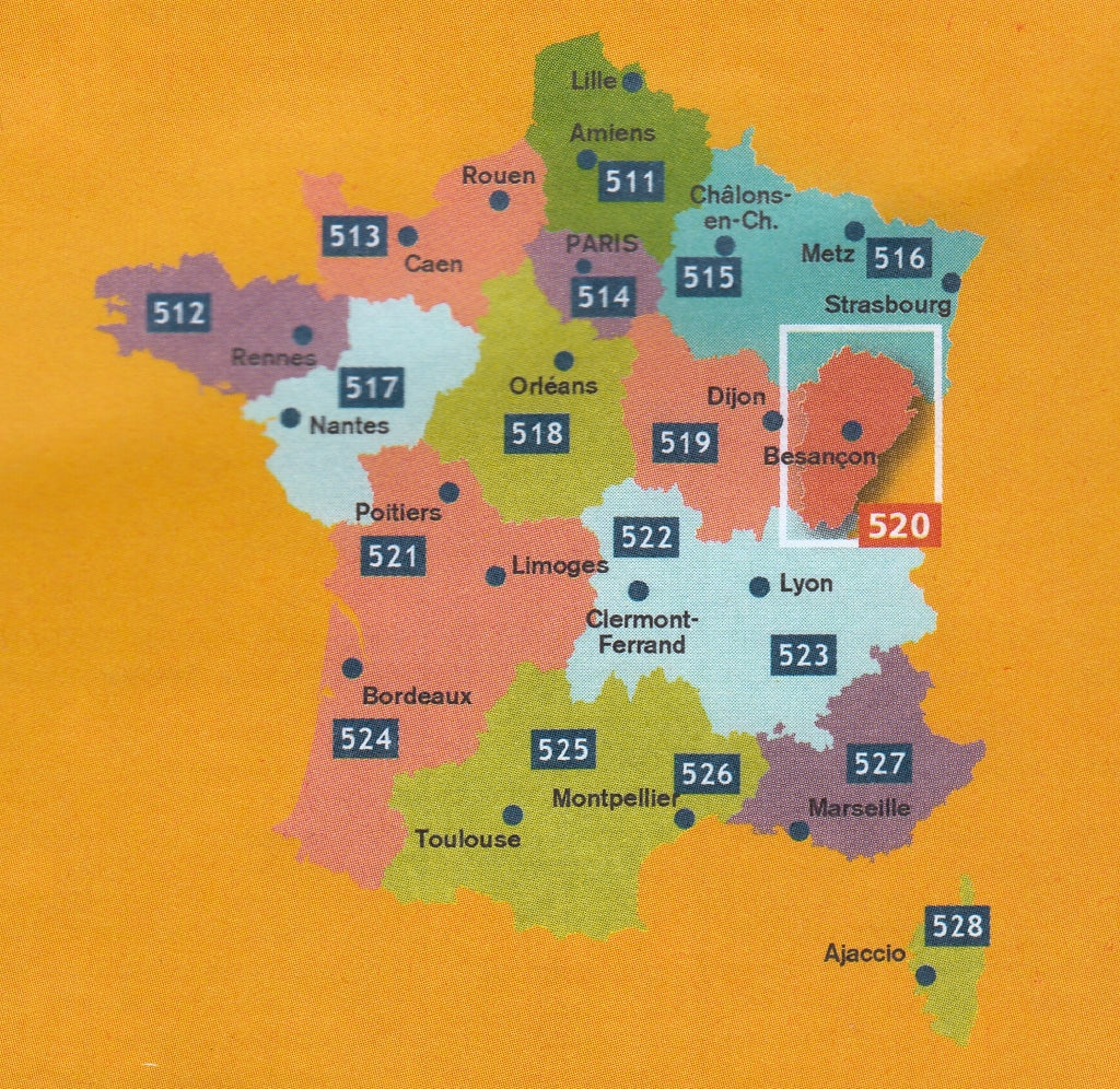
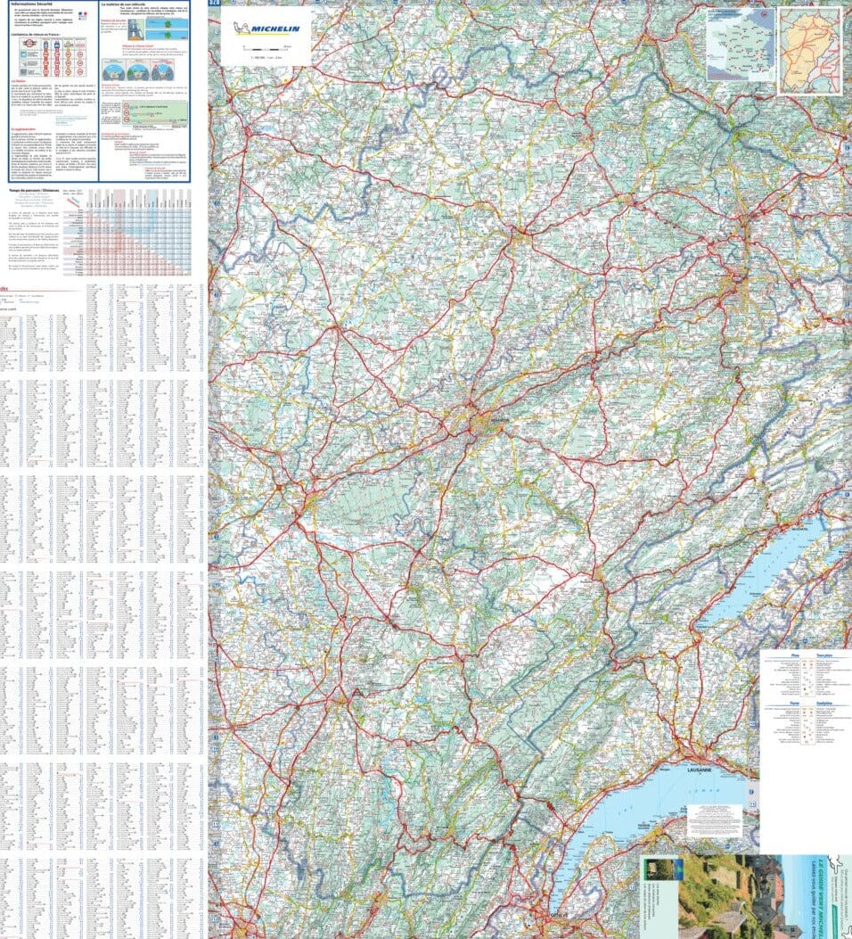
France Franche - Comte 520 Michelin Map
Sold Out
Afterpay is only available for orders between $50.00 and $1000.00 More info
Scale 1:200,000 | Folded Paper Map | Explore Eastern France in Detail
🧭 Explore the Quiet Charm of Franche-Comté with Michelin's Trusted Cartography
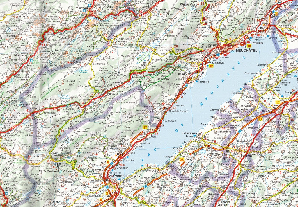
Venture into the untamed beauty and cultural depth of Franche-Comté, a region where nature meets heritage. From the misty ridgelines of the Jura Mountains to the storybook streets of Besançon, this map offers a clear, comprehensive, and user-friendly overview of one of France’s most overlooked gems.
Published by Michelin, Europe’s most respected name in cartography, this folded regional map delivers meticulous detail, durable paper quality, and practical route planning tools designed for drivers, cyclists, walkers, and holidaymakers.
🌄 Regional Highlights Include:
-
Jura Mountains – winding roads, hidden villages, and breathtaking scenery ideal for scenic drives and outdoor exploration.
-
Besançon – a UNESCO-listed citadel town straddling the Doubs River.
-
Lons-le-Saunier – the birthplace of Rouget de Lisle and gateway to Jura vineyards.
-
Haut-Jura Regional Natural Park – alpine forests, hiking trails, and wildlife.
-
Cross-border Routes – seamless navigation into nearby Switzerland, including Geneva and Neuchâtel regions.
🛣️ Features at a Glance
| ✔️ | Feature |
|---|---|
| 🛣️ | All road types clearly shown — motorways, national, regional, and scenic routes |
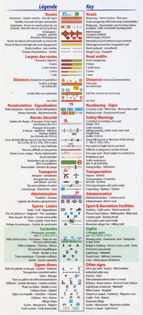
| 🧭 | Multilingual map key — in English, French, German, Spanish & Italian |
| 🏞️ | Tourist attractions — national parks, viewpoints, castles, and cultural sites |
| 🗺️ | City & town insets — extra detail for navigating larger urban centres |
| 📏 | Distance and driving time charts — perfect for road trip planning |
| 🗂️ | Comprehensive index — locate towns, landmarks, and key destinations quickly |
📍 Map Coverage
This map includes all key departments of the Franche-Comté region:
-
Doubs
-
Jura
-
Haute-Saône
-
Territoire de Belfort
Also includes cross-border access to adjacent areas in Switzerland and nearby regions in Burgundy and Rhône-Alpes.
📐 Map Specifications
| Specification | Detail |
|---|---|
| Product Title | Michelin Regional Map 520 – Franche-Comté |
| Scale | 1:200,000 (1 cm = 2 km) |
| Dimensions (unfolded) | 1200 mm x 1000 mm |
| Format | Folded paper map |
| Map Edition | Most recent official Michelin update |
| Language | Multilingual key (EN, FR, DE, ES, IT) |
| Series | Michelin France Regional Series |
🧳 Who Is This Map For?
-
Road Trippers & Drivers – comprehensive coverage of road networks including detours and scenic routes.
-
Hikers & Cyclists – a superb base for exploring forested trails and nature parks.
-
Cultural Travellers – visit medieval towns, hilltop villages, and historical sites.
-
Holidaymakers – plan visits to spas, vineyards, and charming guesthouses.
-
Professional Drivers & Couriers – reliable mapping for logistics and delivery planning.
📦 Delivery & Order Info
-
Format: Folded paper map
-
Ships from Australia
Franche-Comté awaits — a region of mountains, rivers, and centuries-old villages. With Michelin Map 520, your journey through this storied landscape will be informed, effortless, and unforgettable.


