- Australia ▾
- Topographic
▾
- Australia AUSTopo 250k (2025)
- Australia 50k Geoscience maps
- Australia 100k Geoscience maps
- Australia 250k Geoscience maps
- Australia 1:1m Geoscience maps
- New Zealand 50k maps
- New Zealand 250k maps
- New South Wales 25k maps
- New South Wales 50k maps
- New South Wales 100k maps
- Queensland 10k maps
- Queensland 25k maps
- Queensland 50k maps
- Queensland 100k maps
- Compasses
- Software
- GPS Systems
- Orienteering
- International ▾
- Wall Maps
▾
- World
- Australia & New Zealand
- Countries, Continents & Regions
- Historical
- Vintage National Geographic
- Australian Capital Territory
- New South Wales
- Northern Territory
- Queensland
- South Australia
- Tasmania
- Victoria
- Western Australia
- Celestial
- Children's
- Mining & Resources
- Wine Maps
- Healthcare
- Postcode Maps
- Electoral Maps
- Nautical ▾
- Flags
▾
- Australian Flag Sets & Banners
- Flag Bunting
- Handwavers
- Australian National Flags
- Aboriginal Flags
- Torres Strait Islander Flags
- International Flags
- Flagpoles & Accessories
- Australian Capital Territory Flags
- New South Wales Flags
- Northern Territory Flags
- Queensland Flags
- South Australia Flags
- Tasmania Flags
- Victoria Flags
- Western Australia Flags
- Gifts ▾
- Globes ▾
Dear valued customer. Please note that our checkout is not supported by old browsers. Please use a recent browser to access all checkout capabilities


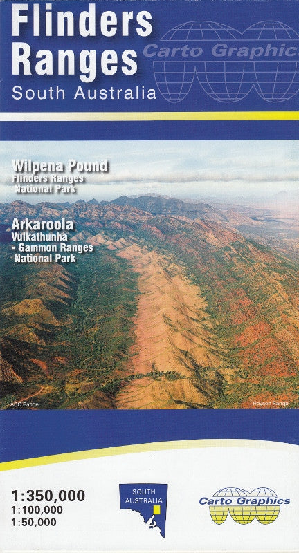

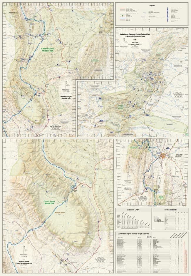
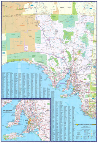
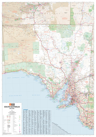
Flinders Ranges Cartographics Map
$11.95
Afterpay is only available for orders between $50.00 and $1000.00 More info
Double-Sided Adventure Map | Full Regional Coverage + Detailed Insets
Main Scale: 1:350,000 | Size: 1000 mm (W) × 700 mm (H) | Format: Folded or Laminated
Explore one of Australia’s most iconic and geologically rich outback regions with this comprehensive Flinders Ranges Map by Carto Graphics. Meticulously updated for touring, walking, and conservation use, this double-sided map covers the entire Flinders Ranges region—from pastoral townships and remote gorges to national parks, 4WD tracks, and rugged escarpments.
Perfect for 4WD travellers, hikers, campers, ecotourists, and educators, this map provides both broad planning scope and highly focused trail detail.
🧭 Features at a Glance
| ✅ Feature | 📍 Description |
|---|---|
| 🗺️ Main Regional Map (1:350,000) | Full coverage of the Flinders Ranges region with shaded relief and detailed topography |
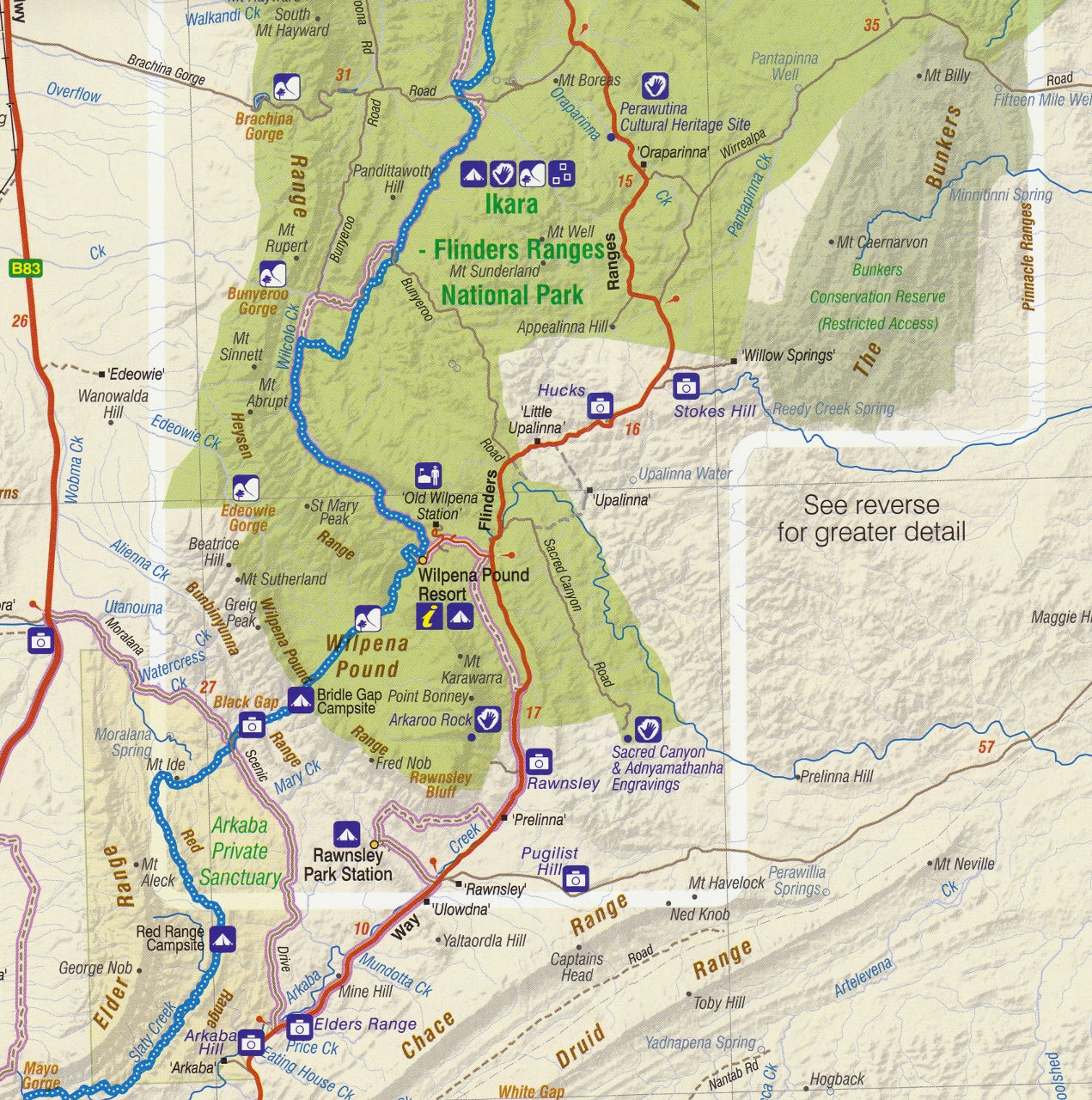
| 🌿 Inset: Ikara–Flinders Ranges National Park | Discover the landscapes and gorges that define this World Heritage-listed area |
| 🥾 Inset: Wilpena Pound | Walking trail map of the iconic natural amphitheatre and surrounds |
| 🏞️ Inset: Dutchmans Stern Conservation Park | Tracks, contours, and features ideal for day-walkers |
| 🏜️ Inset: Vulkathunha–Gammon Ranges & Arkaroola | Detailed map for remote and rugged exploration, including geological points of interest |
| 🚙 4WD Routes & Touring Roads | Unsealed roads, tracks, and route classifications for safe trip planning |
| ⛺ Camping & Visitor Facilities | Campgrounds, station stays, bush camps, scenic lookouts, and toilets clearly marked |
| 🚫 Protected Zones Highlighted | Indigenous Protected Areas, conservation parks, reserves, and national parks |
| 📍 Topographic Detail | Elevation shading, landform contours, and ridge markings for navigation accuracy |
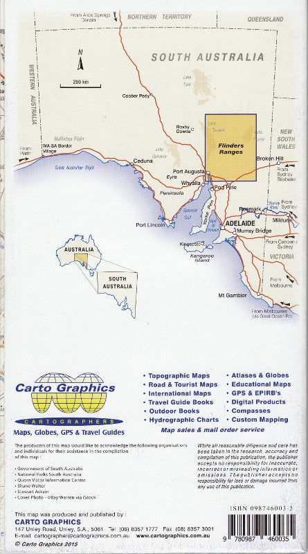
🗺️ Coverage Area
The map extends across the entire Flinders Ranges, from the Southern Ranges near Quorn and Wilmington through to:
-
Hawker & Wilpena Pound
-
Blinman, Parachilna & Copley
-
Leigh Creek & Beltana
-
Mount Chambers & Arkaroola Wilderness Sanctuary
-
Vulkathunha–Gammon Ranges National Park
Whether you're visiting for a weekend in Wilpena Pound, hiking the Bunyeroo Valley, exploring geological marvels like the Brachina Gorge Geological Trail, or undertaking a full outback loop through Arkaroola, this map has you covered.
🧳 Who Is It For?
This map is designed to serve a broad range of users:
-
🏕️ Camping and caravanning families exploring Flinders Ranges National Park
-
🥾 Bushwalkers and trail runners tackling trails like St Mary Peak or Dutchmans Stern
-
🚙 4WD explorers navigating Brachina Gorge, Arkaroola Ridge Top Track, or Balcanoona
-
🧑🏫 Geography educators and students studying the region's uplift, gorges, and rift valleys
-
📸 Photographers and naturalists seeking wildlife, views, and remote beauty
-
🧭 Tour guides and planners offering outback experiences in South Australia
📐 Product Specifications
| Specification | Detail |
|---|---|
| Publisher | Carto Graphics (South Australia) |
| Format | Folded touring map |
| Optional Version | Laminated (see below) |
| Map Size (Flat) | 1000 mm (W) × 700 mm (H) |
| Main Map Scale | 1:350,000 |
| Inset Scales | Approx. 1:100,000 – 1:50,000 for parks |
| Material | Heavyweight paper or laminated gloss |
| Printed in | Australia |
🧴 Optional Laminated Edition
Looking for a field-durable, weatherproof version? Choose our laminated map, which:
-
🧽 Allows use of whiteboard markers – perfect for route planning
-
💧 Is waterproof and tear-resistant – ideal for outdoor use
-
🔒 Is protected with 80-micron gloss encapsulation
-
💼 Suitable for long-term use in classrooms, field offices, 4WD kits, and expedition gear
ℹ️ Please note: map is flattened from folded stock before lamination, so faint fold lines may still be visible.
🛒 Add to Cart – Navigate the Outback with Confidence
The Flinders Ranges Touring Map is more than a navigational tool—it’s a passport to one of Australia’s oldest and most dramatic landscapes. Whether you’re hiking through Wilpena Pound or driving the Arkaroola wilderness, this map will guide your way with clarity and confidence.
📦 Available folded for portability or laminated for rugged use – select your version before checkout.