- Australia ▾
- Topographic
▾
- Australia AUSTopo 250k (2024)
- Australia 50k Geoscience maps
- Australia 100k Geoscience maps
- Australia 250k Geoscience maps
- Australia 1.1m Geoscience maps
- New Zealand 50k maps
- New Zealand 250k maps
- New South Wales 25k maps
- New South Wales 50k maps
- New South Wales 100k maps
- Queensland 10k maps
- Queensland 25k maps
- Queensland 50k maps
- Queensland 100k maps
- Compasses
- Software
- GPS Systems
- Orienteering
- International ▾
- Wall Maps
▾
- World
- Australia & New Zealand
- Countries, Continents & Regions
- Historical
- Vintage National Geographic
- Australian Capital Territory
- New South Wales
- Northern Territory
- Queensland
- South Australia
- Tasmania
- Victoria
- Western Australia
- Celestial
- Children's
- Mining & Resources
- Wine Maps
- Healthcare
- Postcode Maps
- Electoral Maps
- Nautical ▾
- Flags
▾
- Australian Flag Sets & Banners
- Flag Bunting
- Handwavers
- Australian National Flags
- Aboriginal Flags
- Torres Strait Islander Flags
- International Flags
- Flagpoles & Accessories
- Australian Capital Territory Flags
- New South Wales Flags
- Northern Territory Flags
- Queensland Flags
- South Australia Flags
- Tasmania Flags
- Victoria Flags
- Western Australia Flags
- Gifts ▾
- Globes ▾
Dear valued customer. Please note that our checkout is not supported by old browsers. Please use a recent browser to access all checkout capabilities


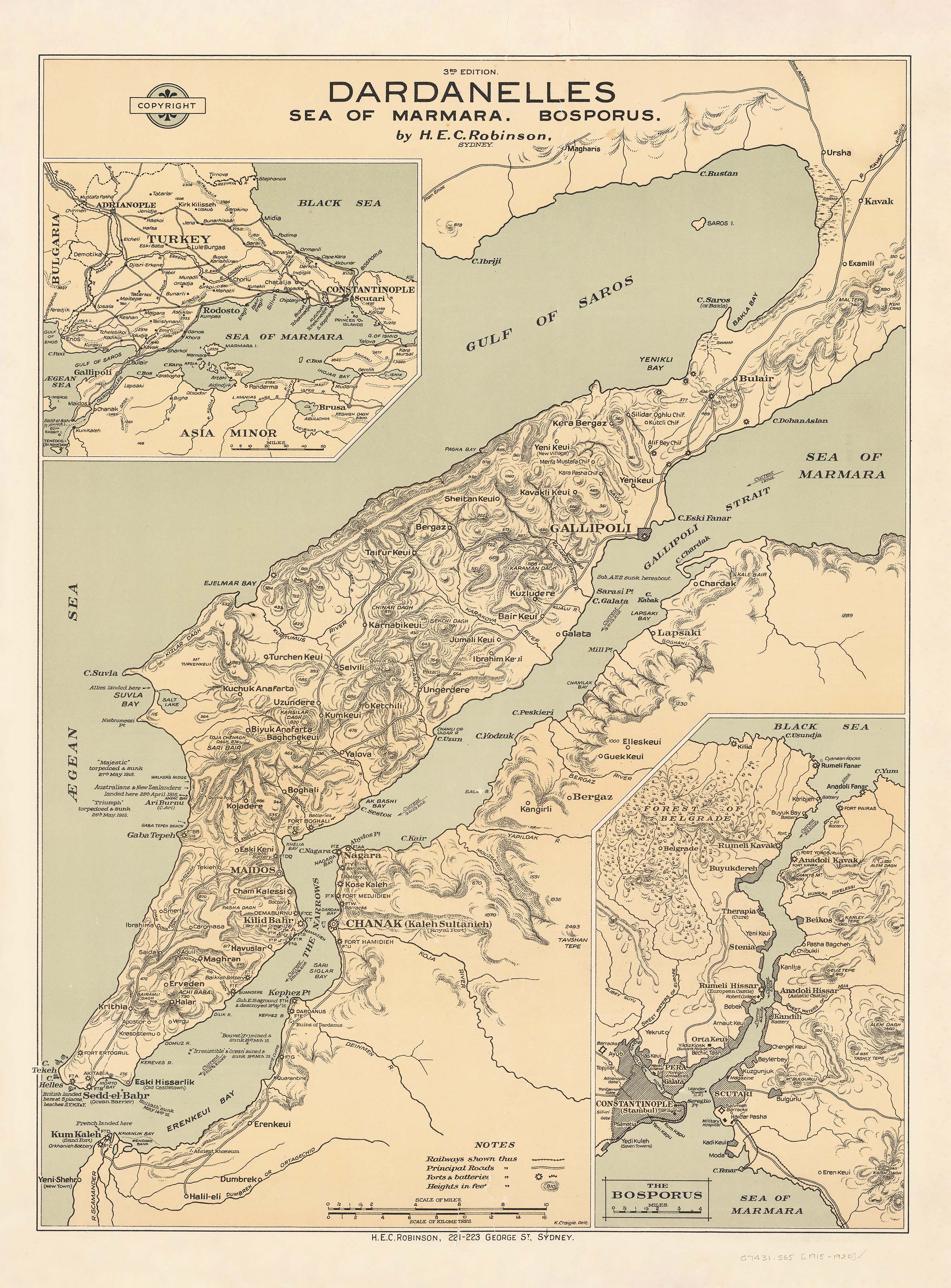
Dardanelles - Sea of Marmara & Bosphorus Wall Map published 1917
$69.95
or make 4 interest-free payments of
$17.49 AUD
fortnightly with
![]() More info
More info
Published: 1917 by H.E.C. Robinson
Sizes Available: Large (660 x 900 mm) / Supermap (960 x 1300 mm)
Step back in time with this remarkable historical map, first published in 1917 during the First World War by the legendary Australian cartographers, H.E.C. Robinson. This highly detailed map captures the strategic layout of the Gallipoli Peninsula, Sea of Marmara, and Bosphorus Strait, offering rare insight into the region’s geography at the height of the Gallipoli Campaign.
A true collector’s piece for military history enthusiasts, educators, and descendants of ANZAC soldiers, this map meticulously charts railways, principal roads, forts, coastal batteries, and landing sites—including the prominent ANZAC Cove. Supporting inset maps include a broader regional overview and a focused illustration of the Bosphorus, providing context and strategic perspective.
🧭 Map Features:
-
Main map: Dardanelles and Gallipoli Peninsula
-
Inset maps:
• Bosphorus Strait
• Sea of Marmara – Regional Overview -
Detailed annotations of:
• Railways and roads
• Fortifications and artillery batteries
• Allied landing zones, including ANZAC positions -
Published by H.E.C. Robinson, one of Australia’s foremost mapmakers
-
A historically significant record of one of WWI’s defining campaigns
🖨️ Available Finishes
Choose the format that best suits your purpose or display environment:
1. Paper (160 gsm)
-
Ideal for framing under glass
-
Lightweight and archival-quality print
2. Laminated (Encapsulated Gloss)
-
Printed on premium stock and sealed between 80-micron gloss laminate sheets
-
Wipeable surface—perfect for whiteboard markers and map dots
-
Resistant to tears, stains, and daily wear
3. Canvas (395 gsm HP Matte Professional Canvas)
-
Printed using pigment-based inks for exceptional clarity and fade resistance
-
Durable and elegant—perfect for home, study, or office decor
-
Museum-quality reproduction with a textured, matte finish
✅ Optional Timber Hang Rails (Lamianted & Canvas Only)
Laminated & Canvas maps can be mounted with natural timber hang rails and a top cord, making hanging as simple as placing a hook on the wall.
📐 Size Options
| Format | Width | Height |
|---|---|---|
| Large | 660 mm | 900 mm |
| Supermap | 960 mm | 1300 mm |
📦 Note: maps with hang rails are assembled to order. Please allow up to 10 working days for delivery.
🇦🇺 Made in Australia – Preserving ANZAC Legacy
This map is not just a geographic reference—it's a vivid piece of military history. With detailed historical annotations and period-authentic design, it is an exceptional way to honour and remember the ANZAC forces who fought in one of the most significant campaigns of World War I.
Bring history to life with this unique and powerful wall map—an enduring tribute to those who served.
Ideal for history buffs, military scholars, and anyone with a deep respect for the past.