- Australia ▾
- Topographic
▾
- Australia AUSTopo 250k (2025)
- Australia 50k Geoscience maps
- Australia 100k Geoscience maps
- Australia 250k Geoscience maps
- Australia 1:1m Geoscience maps
- New Zealand 50k maps
- New Zealand 250k maps
- New South Wales 25k maps
- New South Wales 50k maps
- New South Wales 100k maps
- Queensland 10k maps
- Queensland 25k maps
- Queensland 50k maps
- Queensland 100k maps
- Western Australia 25k maps
- Western Australia 50k maps
- Western Australia 100k maps
- Compasses
- Software
- GPS Systems
- International ▾
- Wall Maps
▾
- World
- Australia & New Zealand
- Countries, Continents & Regions
- Historical
- Vintage National Geographic
- Australian Capital Territory
- New South Wales
- Northern Territory
- Queensland
- South Australia
- Tasmania
- Victoria
- Western Australia
- Celestial
- Children's
- Mining & Resources
- Wine Maps
- Healthcare
- Postcode Maps
- Electoral Maps
- Nautical ▾
- Flags
▾
- Australian Flag Sets & Banners
- Flag Bunting
- Handwavers
- Australian National Flags
- Aboriginal Flags
- Torres Strait Islander Flags
- International Flags
- Flagpoles & Accessories
- Australian Capital Territory Flags
- New South Wales Flags
- Northern Territory Flags
- Queensland Flags
- South Australia Flags
- Tasmania Flags
- Victoria Flags
- Western Australia Flags
- Gifts ▾
- Globes ▾
Dear valued customer. Please note that our checkout is not supported by old browsers. Please use a recent browser to access all checkout capabilities


Croatia ITMB Map
$24.95
Afterpay is only available for orders between $50.00 and $1000.00 More info
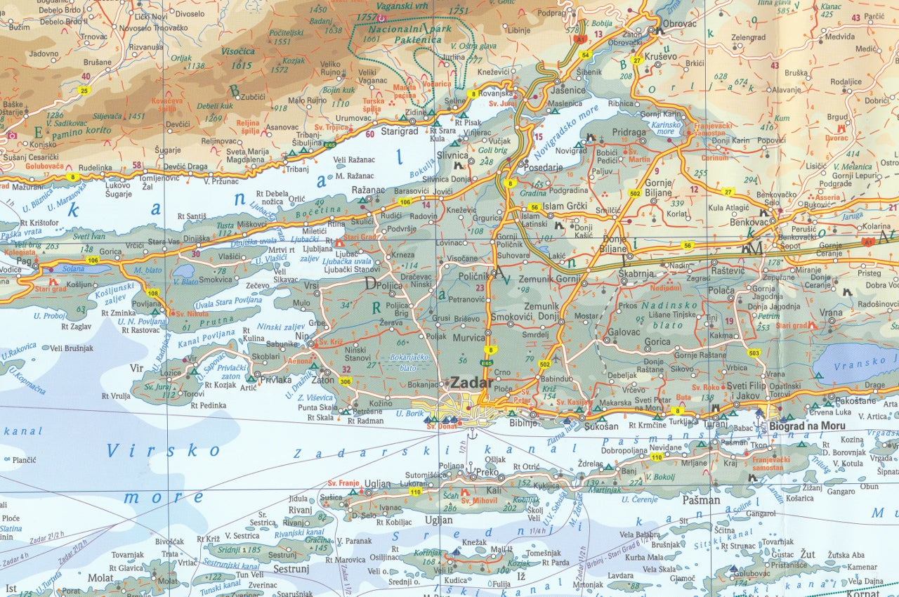
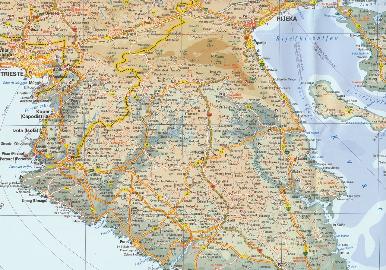
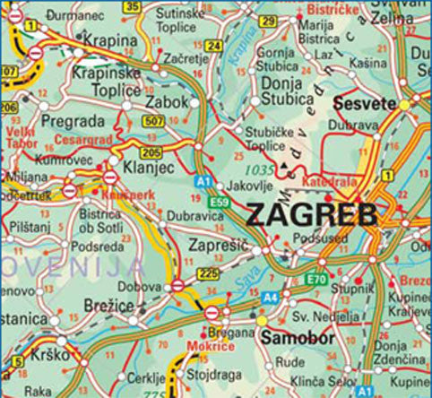
Explore the shimmering Adriatic coast, historic cities, and scenic landscapes of Croatia with this detailed travel map from ITMB. Whether you’re planning a coastal road trip, a historical tour through inland cities, or an island-hopping sailing adventure, this folded map offers the clarity, accuracy, and detail needed to navigate one of Europe’s most enchanting destinations.
🇭🇷 Why Travel to Croatia?
Croatia is one of Europe’s rising stars — a country where Roman ruins, medieval towns, and turquoise waters come together under the Mediterranean sun. It has transformed itself into a safe, friendly, and exceptionally tourist-ready destination in the decades since the Yugoslav conflicts of the 1990s. Today, it boasts:
-
🏰 Ancient Cities & World Heritage Sites: Stroll the marble streets of Dubrovnik, admire Diocletian’s Palace in Split, or explore the lively streets of Zagreb.
-
🌊 Stunning Coastlines: Over 1,000 islands and islets dot the Adriatic, offering world-class sailing, beach escapes, and breathtaking views.
-
🏞️ Natural Beauty: From Plitvice Lakes National Park to the rugged Dinaric Alps, nature lovers will find plenty of hiking, biking, and exploring opportunities.
-
🧭 Well-Maintained Infrastructure: Excellent roads, modern motorways, regular ferry routes, and tourist-friendly services throughout the country.
-
🌞 Ideal Weather: Warm Mediterranean summers and mild winters make it a popular destination year-round.
Though Croatia is a member of NATO and the European Union, it remains outside the Schengen Area for now, which means border checks with neighbouring EU states are still in place — though typically minimal in formality.
🗺️ Map Features
Produced by ITMB (International Travel Maps), this folded map of Croatia is printed at a practical scale of 1:300,000, making it ideal for travel use, regional planning, or educational reference.
✔️ Cartographic Highlights:
-
Entire country of Croatia, from the Istrian Peninsula to Dubrovnik
-
Clearly marked motorways, roads, highways, and ferry connections
-
Updated transport infrastructure including the new Pelješac Bridge, under construction to bypass the Bosnian corridor and link southern Croatia directly with the mainland
-
Tourist icons indicating:
-
🏛️ Historical and cultural sites
-
⛱️ Beaches and coastal attractions
-
🏕️ National parks and nature reserves
-
🛥️ Ports and ferry routes
-
-
Detailed border crossings, including informal EU checkpoints
-
Insets of major cities including:
-
Zagreb
-
Split
-
Dubrovnik
-
Rijeka
-
-
Shaded relief to indicate topography, mountain ranges, and terrain
🧾 Map Specifications
| Specification | Detail |
|---|---|
| Publisher | ITMB (International Travel Maps) |
| Scale | 1:300,000 |
| ISBN | 9781771298165 |
| Flat Size | 690 mm x 1000 mm (27" x 39") |
| Format | Folded paper map |
| Edition | Latest edition available |
🛡️ Optional Lamination Available
We offer this map in a laminated format, ideal for:
-
✅ Writing with whiteboard markers
-
✅ Applying removable map dots or stickers
-
✅ Protecting against moisture, stains, and tears
-
✅ Use in classrooms, travel offices, or mounted on walls
Our lamination process involves flattening the folded map and fully encapsulating it in 80-micron gloss laminate, making it both durable and reusable. Please note that minor fold lines may still be visible due to the map's original format.
🧭 Who Is This Map For?
This Croatia ITMB Travel Map is perfect for:
-
✈️ Travellers & Holidaymakers: Planning a road trip, cruise, or beach holiday in Croatia
-
🧳 Backpackers & Adventurers: Exploring national parks, hiking routes, and hidden inland gems
-
🏫 Teachers & Students: Useful for classroom reference or educational displays
-
🗂️ Tour Operators & Agencies: Displaying regional coverage and tourist infrastructure
-
🖼️ Map Enthusiasts & Collectors: A detailed, attractive addition to any map collection
✨ Why Choose ITMB Maps?
-
🖨️ Crisp, legible printing with vibrant colour differentiation
-
🌍 Focus on travel usability: Icons, cities, attractions, and routes are presented clearly
-
🗺️ Global coverage: ITMB produces maps for over 300 destinations worldwide
Take the stress out of navigating Croatia and enhance your journey with this informative, easy-to-use map. Whether you're tracing the coastline by car, plotting a ferry route, or exploring the interior, this map is your trusted travel companion.
Frequently Asked Questions
Where can I buy the Croatia ITMB Map?
The Croatia ITMB Map is available to buy online from Mapworld, Australia's largest map and geographic product retailer, with fast shipping Australia-wide.
Is the Croatia ITMB Map in stock at Mapworld?
Mapworld maintains extensive stock across its map range and aims for fast dispatch. Orders placed before 2pm AEST on business days are typically dispatched the same day, with standard and express Australia-wide delivery options available.
What is Mapworld's returns policy?
Mapworld accepts returns on undamaged items in original condition. Contact Mapworld within 90 days of purchase to arrange a return or exchange.
Does Mapworld ship the Croatia ITMB Map across Australia?
Yes, Mapworld ships Australia-wide. Standard shipping is a flat $7 rate, with free standard shipping on orders over $75. Express options are available at checkout. Most orders placed before 2pm AEST on weekdays are dispatched same day.
Related Items


© 2026 Mapworld. Website designed by Genie Media
X