- Australia ▾
- Topographic
▾
- Australia AUSTopo 250k (2025)
- Australia 50k Geoscience maps
- Australia 100k Geoscience maps
- Australia 250k Geoscience maps
- Australia 1:1m Geoscience maps
- New Zealand 50k maps
- New Zealand 250k maps
- New South Wales 25k maps
- New South Wales 50k maps
- New South Wales 100k maps
- Queensland 10k maps
- Queensland 25k maps
- Queensland 50k maps
- Queensland 100k maps
- Western Australia 25k maps
- Western Australia 50k maps
- Western Australia 100k maps
- Compasses
- Software
- GPS Systems
- International ▾
- Wall Maps
▾
- World
- Australia & New Zealand
- Countries, Continents & Regions
- Historical
- Vintage National Geographic
- Australian Capital Territory
- New South Wales
- Northern Territory
- Queensland
- South Australia
- Tasmania
- Victoria
- Western Australia
- Celestial
- Children's
- Mining & Resources
- Wine Maps
- Healthcare
- Postcode Maps
- Electoral Maps
- Nautical ▾
- Flags
▾
- Australian Flag Sets & Banners
- Flag Bunting
- Handwavers
- Australian National Flags
- Aboriginal Flags
- Torres Strait Islander Flags
- International Flags
- Flagpoles & Accessories
- Australian Capital Territory Flags
- New South Wales Flags
- Northern Territory Flags
- Queensland Flags
- South Australia Flags
- Tasmania Flags
- Victoria Flags
- Western Australia Flags
- Gifts ▾
- Globes ▾
Dear valued customer. Please note that our checkout is not supported by old browsers. Please use a recent browser to access all checkout capabilities


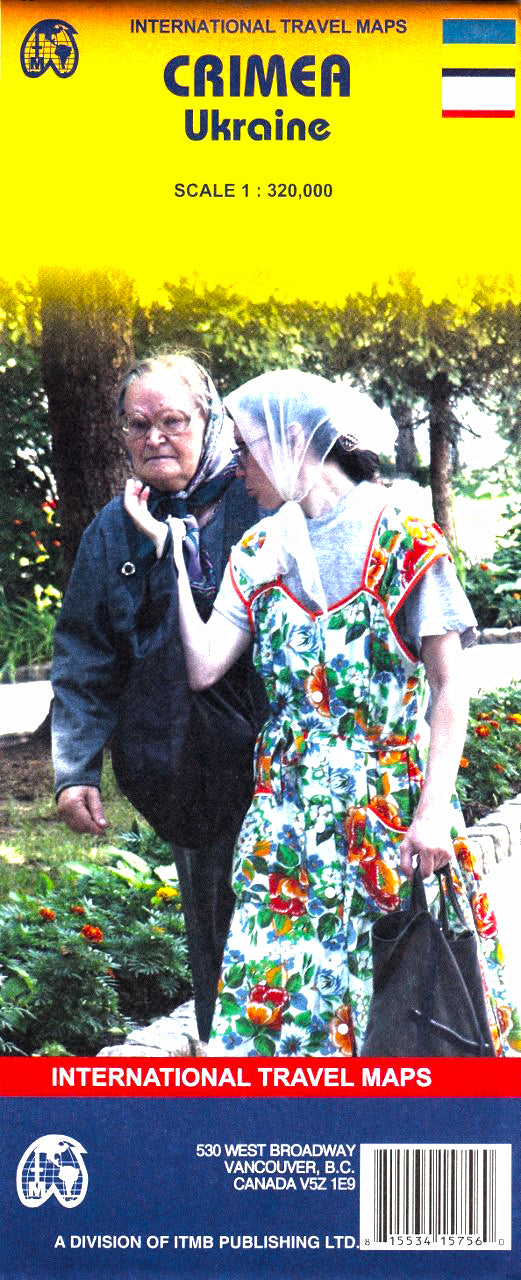
Crimea (Ukraine) ITMB Map
$24.95
Afterpay is only available for orders between $50.00 and $1000.00 More info
Accurate, Up-to-Date, and Ideal for Travellers, Educators, and Researchers
Scale: 1:320,000 | Size: 690 mm x 990 mm | Optional Lamination
🌍 Discover the Rich History and Geography of Crimea
The Crimea (Ukraine) map by ITMB (International Travel Maps) offers travellers, academics, and curious explorers a detailed view of one of the most geopolitically and culturally fascinating regions in Europe. Strategically located on the Black Sea and known for its diverse landscapes, rich history, and contested past, Crimea has long been a destination of intrigue and beauty.
This updated and independently produced regional map provides a clear, neutral, and thorough portrayal of the peninsula’s modern layout — featuring roads, towns, landmarks, and coastal contours. It's a dedicated expansion of ITMB’s larger Ukraine map, offering much more detailed regional coverage.
🗝️ Key Features & Benefits
-
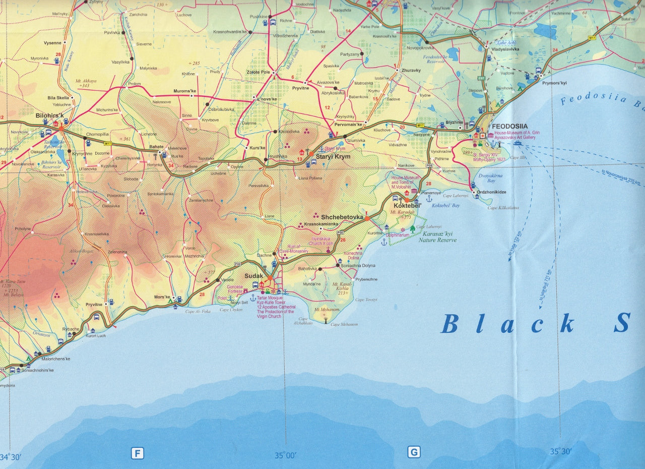
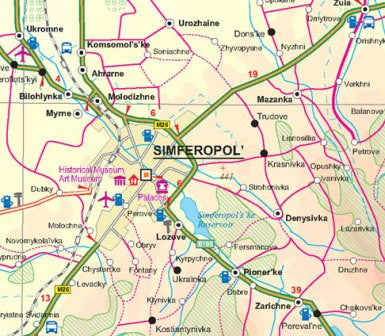
✅ Detailed Road Network
Includes major highways, local roads, ferry routes, and distances, perfect for route planning and logistics. -
✅ Accurate Geographic Relief
Terrain is shown using shaded relief, depicting Crimea’s mountains, coastlines, valleys, and inland plateaus. -
✅ Comprehensive Index
Fully indexed for easy navigation of towns, cities, and key locations — helpful for academic and practical use. -
✅ City Highlights & Inset Features
Includes key urban centres such as Simferopol, Sevastopol, Yalta, Feodosia, Kerch, and more. -
✅ Cultural & Tourist Points of Interest
Historical landmarks, seaside resorts, natural parks, ancient ruins, and museums clearly marked. -
✅ Neutral Cartographic Presentation
Reflects de facto administrative control while remaining politically neutral — ideal for educators and analysts.
💧 Optional Professional Lamination
Upgrade your map with encapsulated lamination — the perfect solution for active use:
-
✏️ Write on it with whiteboard markers
-
📍 Use map dots to mark visited or planned locations
-
🧽 Easily wipe clean and reuse
-
💪 Resists moisture, stains, and tears — ideal for classroom, fieldwork, or office display
Our laminated maps are carefully flattened before encapsulation in premium 80-micron gloss laminate. Fold lines from the original map may remain subtly visible but will not affect usability.
📐 Specifications
| Feature | Description |
|---|---|
| Map Title | Crimea (Ukraine) |
| Publisher | ITMB – International Travel Maps |
| Scale | 1:320,000 |
| Dimensions | 690 mm (W) × 990 mm (H) |
| Map Format | Folded paper (laminated optional) |
| Printing | Full colour on durable map-grade paper |
| Language | English |
| Region Covered | Entire Crimean Peninsula & Black Sea Coast |
| Edition | Most recent edition available |
🧭 Ideal For:
✔️ Travellers exploring the Black Sea coast or planning overland journeys
✔️ Historians & researchers studying Crimea’s geopolitical evolution
✔️ Educators needing reliable, high-detail maps for classroom use
✔️ Cultural tour operators designing routes in Ukraine and the wider region
✔️ Map collectors and cartography enthusiasts
🧳 Why Choose This Map?
-
Produced by ITMB, a world-renowned mapmaker trusted for accuracy and clarity
-
Printed in full colour with terrain shading, city indexing, and road distances
-
Offers deeper regional detail than typical maps of Ukraine
-
Durable, lightweight, and easy to carry — foldable or optionally laminated
🚚 Order & Delivery
This map is in stock and available for immediate dispatch.
Step into the crossroads of history and geography with this detailed Crimea map. Whether you're planning a journey, studying the region, or simply love great cartography, this map delivers insight, clarity, and exceptional quality.
Frequently Asked Questions
Where can I buy the Crimea (Ukraine) ITMB Map?
The Crimea (Ukraine) ITMB Map is available to buy online from Mapworld, Australia's largest map and geographic product retailer, with fast shipping Australia-wide.
Is the Crimea (Ukraine) ITMB Map in stock at Mapworld?
Mapworld maintains extensive stock across its map range and aims for fast dispatch. Orders placed before 2pm AEST on business days are typically dispatched the same day, with standard and express Australia-wide delivery options available.
What is Mapworld's returns policy?
Mapworld accepts returns on undamaged items in original condition. Contact Mapworld within 90 days of purchase to arrange a return or exchange.
Does Mapworld ship the Crimea (Ukraine) ITMB Map across Australia?
Yes, Mapworld ships Australia-wide. Standard shipping is a flat $7 rate, with free standard shipping on orders over $75. Express options are available at checkout. Most orders placed before 2pm AEST on weekdays are dispatched same day.
Related Items


© 2026 Mapworld. Website designed by Genie Media
X