- Australia ▾
- Topographic
▾
- Australia AUSTopo 250k (2025)
- Australia 50k Geoscience maps
- Australia 100k Geoscience maps
- Australia 250k Geoscience maps
- Australia 1:1m Geoscience maps
- New Zealand 50k maps
- New Zealand 250k maps
- New South Wales 25k maps
- New South Wales 50k maps
- New South Wales 100k maps
- Queensland 10k maps
- Queensland 25k maps
- Queensland 50k maps
- Queensland 100k maps
- Compasses
- Software
- GPS Systems
- Orienteering
- International ▾
- Wall Maps
▾
- World
- Australia & New Zealand
- Countries, Continents & Regions
- Historical
- Vintage National Geographic
- Australian Capital Territory
- New South Wales
- Northern Territory
- Queensland
- South Australia
- Tasmania
- Victoria
- Western Australia
- Celestial
- Children's
- Mining & Resources
- Wine Maps
- Healthcare
- Postcode Maps
- Electoral Maps
- Nautical ▾
- Flags
▾
- Australian Flag Sets & Banners
- Flag Bunting
- Handwavers
- Australian National Flags
- Aboriginal Flags
- Torres Strait Islander Flags
- International Flags
- Flagpoles & Accessories
- Australian Capital Territory Flags
- New South Wales Flags
- Northern Territory Flags
- Queensland Flags
- South Australia Flags
- Tasmania Flags
- Victoria Flags
- Western Australia Flags
- Gifts ▾
- Globes ▾
Dear valued customer. Please note that our checkout is not supported by old browsers. Please use a recent browser to access all checkout capabilities


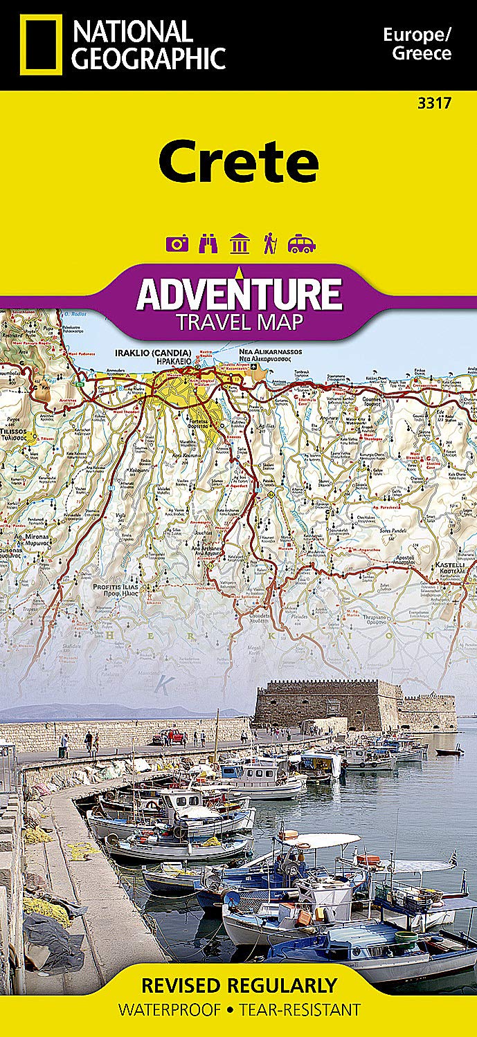
Crete National Geographic Folded Map
$27.95
Afterpay is only available for orders between $50.00 and $1000.00 More info
Folded, Waterproof & Tear-Resistant | Eastern & Western Regions
Explore the largest and most storied of the Greek islands with the Crete Adventure Map by National Geographic—the trusted name in exploration and cartography. Designed specifically for the needs of active travellers and cultural explorers, this durable, waterproof folded map offers a perfect balance of topographic detail, tourist insight, and navigational clarity.
Whether you're navigating ancient Minoan ruins, hiking the Samariá Gorge, or planning a scenic drive along the southern coast, this map ensures you're equipped with the best on-the-go reference.
📌 Key Features
| Attribute | Details |
|---|---|
| Publisher | National Geographic |
| Series | Adventure Map Series |
| Format | Folded, double-sided map |
| Paper Type | Synthetic – waterproof and tear-resistant |
| Folded Size | 235 mm x 108 mm |
| Unfolded Size | 965 mm x 660 mm |
🗺️ Map Coverage
-
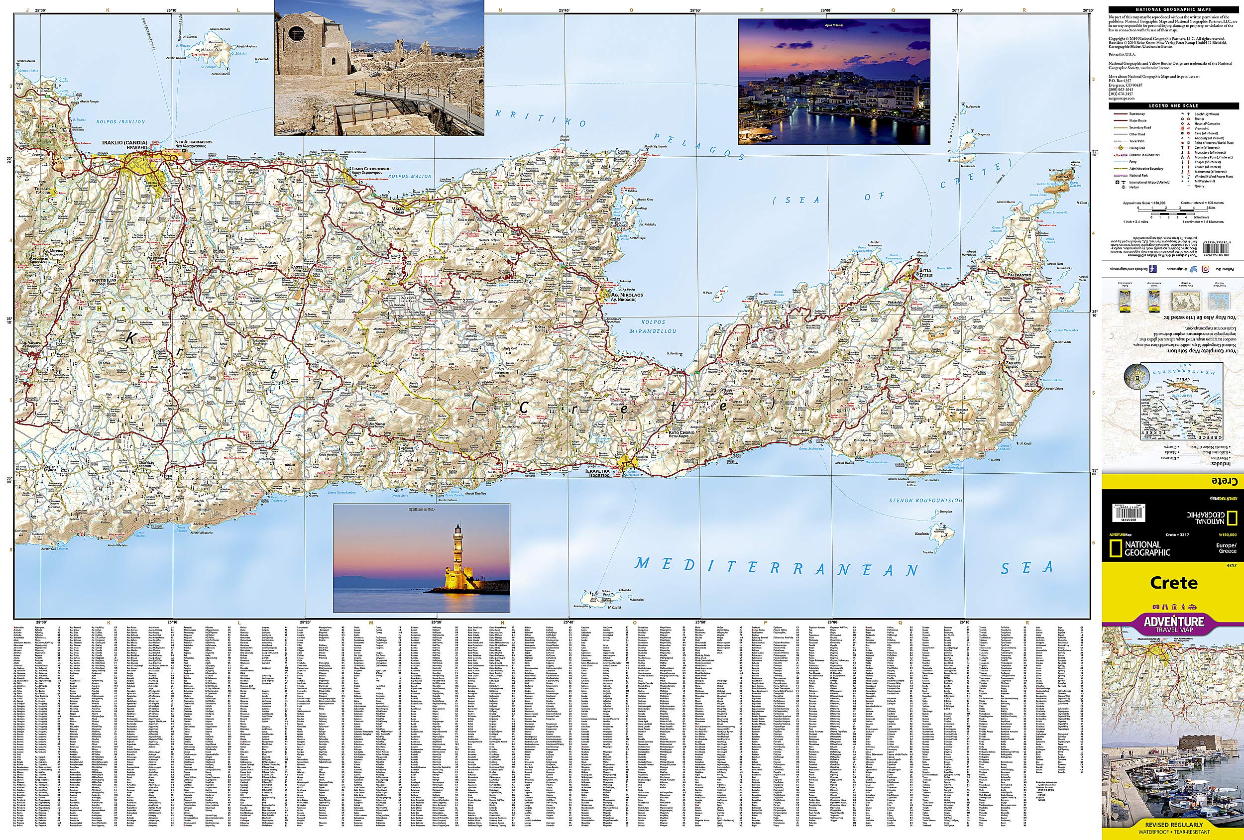
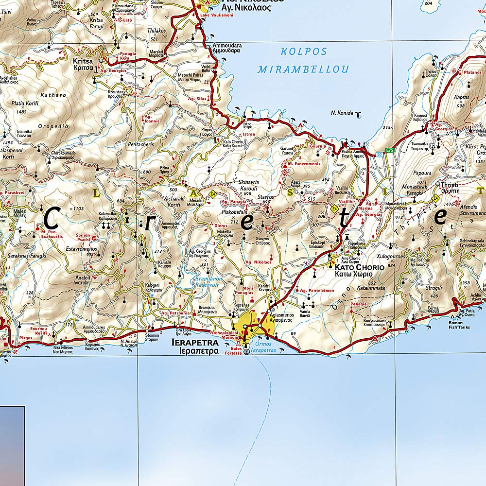
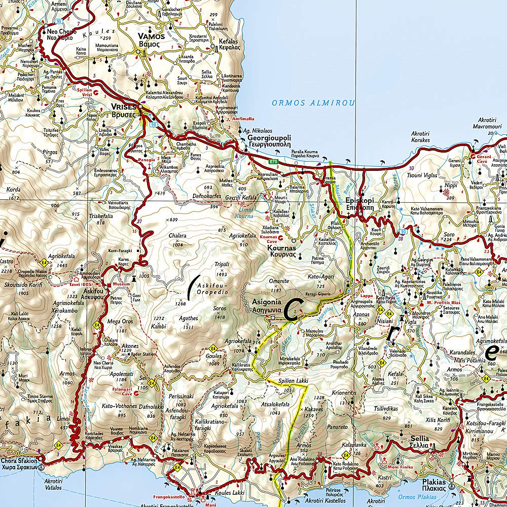
Front Side: Eastern Crete
Includes the regions surrounding Agios Nikolaos, Sitia, and Elounda, with the Sea of Crete to the north. Covers inland roads, remote villages, and notable archaeological sites. -
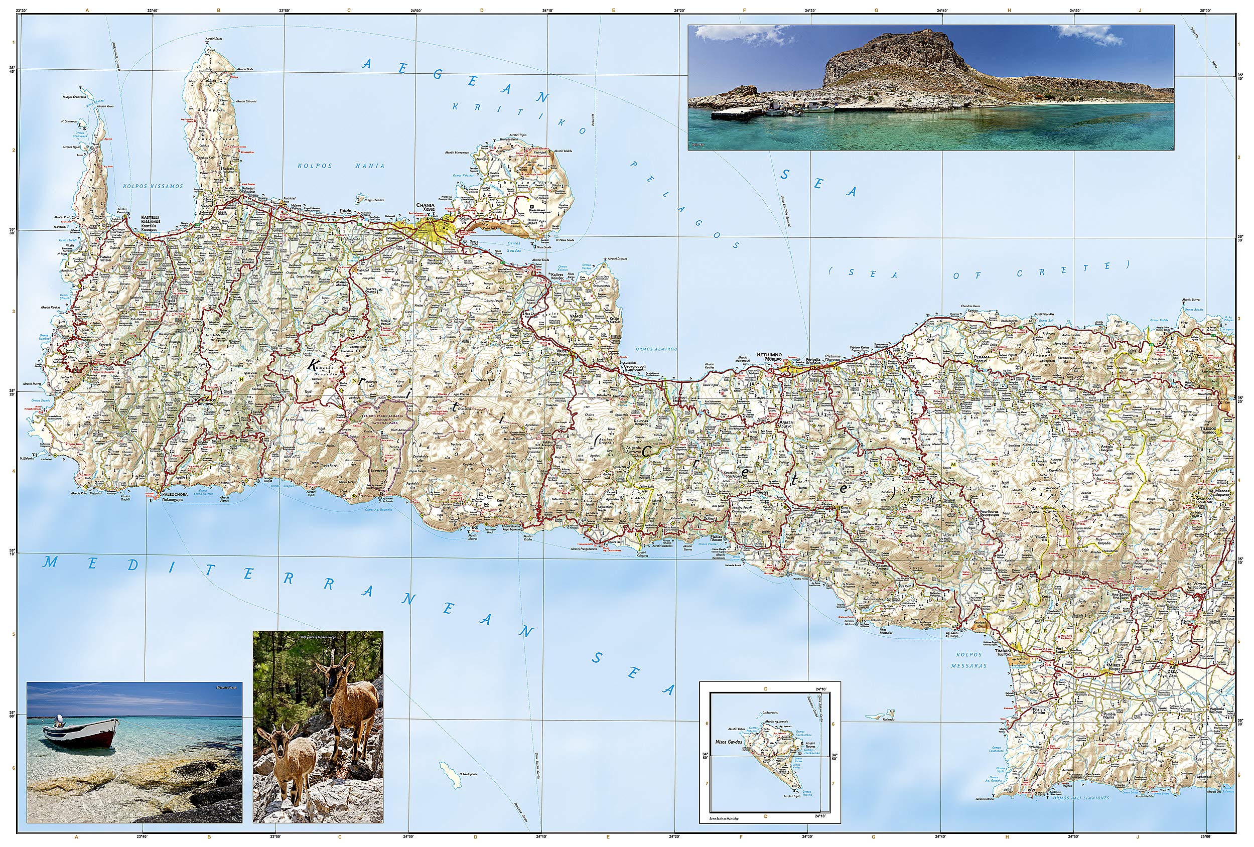
Reverse Side: Western Crete
Covers Chania, Rethymno, and Heraklion, bordered by the Aegean Sea in the north and Libyan Sea (often grouped under the Mediterranean) in the south. Includes famous trekking regions, gorges, beaches, and mountain ranges.
🔍 Map Highlights
-
Fully Indexed: Includes a user-friendly index of cities, towns, and villages to make location-finding easy.
-
Road Network: Clearly marked with road classifications and route distances, including:
-
Major highways
-
Secondary and tertiary roads
-
Remote tracks and trails (ideal for hikers and adventurers)
-
-
Tourist Icons: Highlights hundreds of points of interest including:
-
Ancient ruins (Knossos, Phaistos, Gortyna)
-
Beaches (Elafonissi, Vai)
-
National parks and gorges
-
Ferry terminals and ports
-
-
Topographic Features: Shows terrain contours, mountain ranges, rivers, and coastal formations to help you understand the landscape at a glance.
-
Multilingual Labelling: Place names in both Greek and Roman alphabets, ensuring ease of use for international travellers.
🧗 Built for Adventure
Every National Geographic Adventure Map is crafted to withstand the elements. Printed on a proprietary synthetic material, this map is:
-
✅ Waterproof
-
✅ Tear-resistant
-
✅ Lightweight
-
✅ Packable
Ideal for trekking, cycling, off-road exploration, and backpacking in rugged or remote parts of Crete.
🧳 Ideal For:
-
Cultural travellers interested in Crete’s rich Minoan and Byzantine heritage
-
Hikers and nature lovers exploring gorges, peaks, and national parks
-
Drivers and motorcycle tourers navigating winding scenic roads
-
Eco-tourists and beachgoers seeking hidden coves and seaside villages
-
Anyone who wants a reliable, detailed map that won't fall apart in your pack
🌍 Why Choose National Geographic?
With over a century of exploration experience, National Geographic maps are trusted by geographers, explorers, and adventure travellers worldwide. The Crete Adventure Map is no exception—combining rigorous cartographic standards with cultural depth and real-world usability.
Take the guesswork out of island discovery—navigate Crete with confidence and clarity.
Adventure awaits. Bring the right map.
Frequently Asked Questions
What area does the Crete National Geographic Folded Map cover?
The Crete National Geographic Folded Map provides road coverage of the region named in the product title. The map covers major cities, highways, towns, and regional roads, with inset city maps for key urban centres where applicable.
Is the Crete National Geographic Folded Map up to date?
Yes, this is the current edition. Mapworld stocks the most current editions from all major publishers, updated to reflect new roads and infrastructure.
What size is this map when unfolded?
Folded maps from Mapworld's range are compact and portable. Most standard folded road or travel maps open to between A1 (594 × 841mm) and A0 (841 × 1189mm) when fully unfolded, and fold down to approximately A4 or smaller for easy storage in a glove box, bag, or backpack.
Is the Crete National Geographic Folded Map in stock at Mapworld?
Mapworld maintains extensive stock across its map range and aims for fast dispatch. Orders placed before 2pm AEST on business days are typically dispatched the same day, with standard and express Australia-wide delivery options available.
Does Mapworld ship the Crete National Geographic Folded Map across Australia?
Yes, Mapworld ships Australia-wide. Standard shipping is a flat $7 rate, with free standard shipping on orders over $75. Express options are available at checkout. Most orders placed before 2pm AEST on weekdays are dispatched same day.
Related Items


© 2026 Mapworld. Website designed by Genie Media
X