- Australia ▾
- Topographic
▾
- Australia AUSTopo 250k (2025)
- Australia 50k Geoscience maps
- Australia 100k Geoscience maps
- Australia 250k Geoscience maps
- Australia 1:1m Geoscience maps
- New Zealand 50k maps
- New Zealand 250k maps
- New South Wales 25k maps
- New South Wales 50k maps
- New South Wales 100k maps
- Queensland 10k maps
- Queensland 25k maps
- Queensland 50k maps
- Queensland 100k maps
- Western Australia 25k maps
- Western Australia 50k maps
- Western Australia 100k maps
- Compasses
- Software
- GPS Systems
- International ▾
- Wall Maps
▾
- World
- Australia & New Zealand
- Countries, Continents & Regions
- Historical
- Vintage National Geographic
- Australian Capital Territory
- New South Wales
- Northern Territory
- Queensland
- South Australia
- Tasmania
- Victoria
- Western Australia
- Celestial
- Children's
- Mining & Resources
- Wine Maps
- Healthcare
- Postcode Maps
- Electoral Maps
- Nautical ▾
- Flags
▾
- Australian Flag Sets & Banners
- Flag Bunting
- Handwavers
- Australian National Flags
- Aboriginal Flags
- Torres Strait Islander Flags
- International Flags
- Flagpoles & Accessories
- Australian Capital Territory Flags
- New South Wales Flags
- Northern Territory Flags
- Queensland Flags
- South Australia Flags
- Tasmania Flags
- Victoria Flags
- Western Australia Flags
- Gifts ▾
- Globes ▾
Dear valued customer. Please note that our checkout is not supported by old browsers. Please use a recent browser to access all checkout capabilities


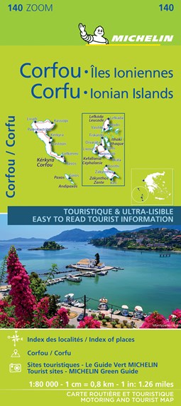
Corfu & Ionian Islands Michelin Map 140
$21.95
Afterpay is only available for orders between $50.00 and $1000.00 More info
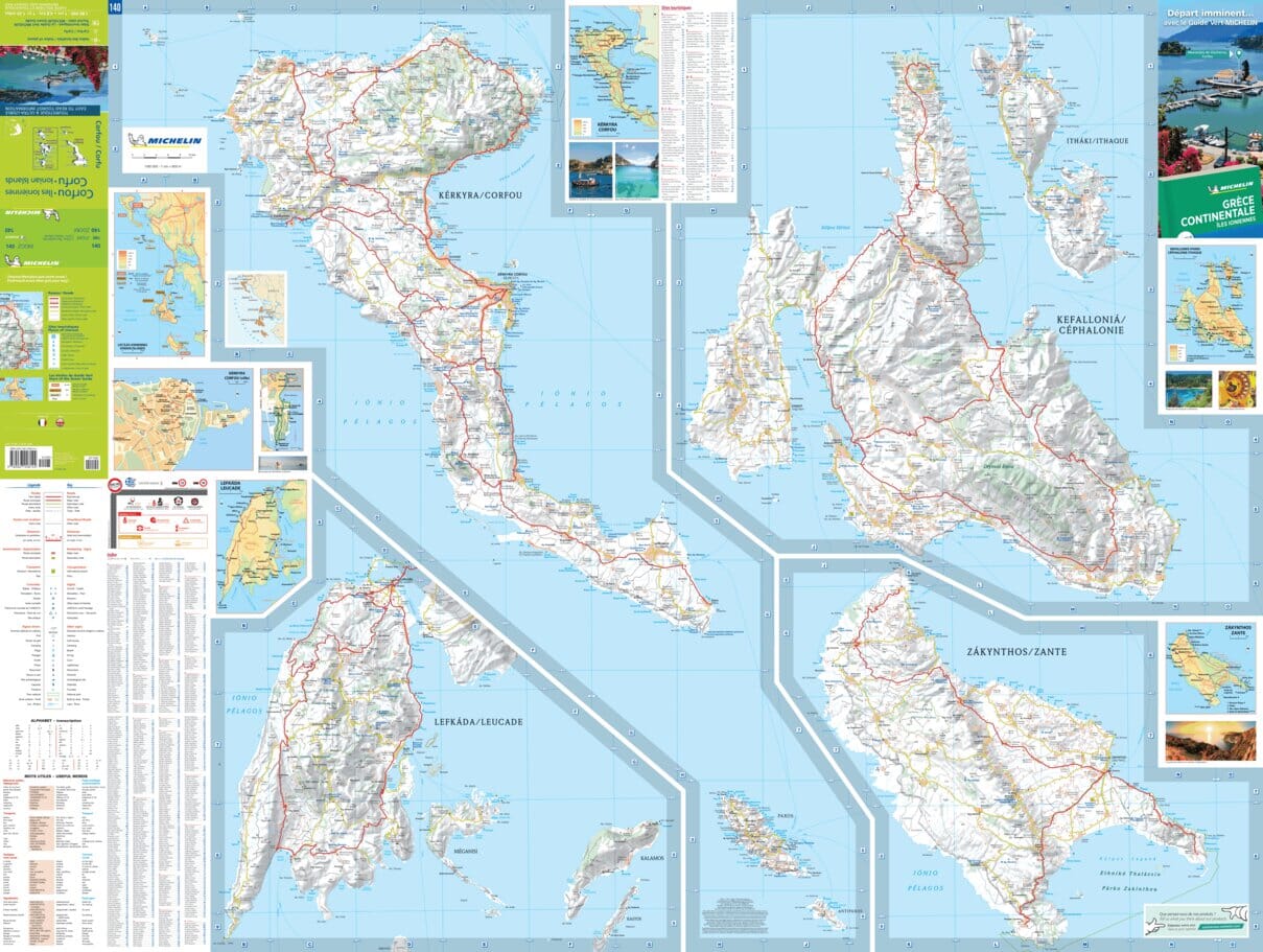
Scale: 1:80,000 | Size: 1200 mm × 1000 mm | Folded Paper Map
🇬🇷 Discover Corfu & the Ionian Islands with Michelin’s Trusted Cartography
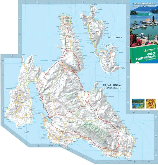
Explore the scenic beauty and timeless heritage of Greece’s Ionian coast with Michelin Map 140 – Corfu & the Ionian Islands. Designed with clarity, accuracy, and ease of use in mind, this folded road and tourist map provides the perfect balance of navigational detail and travel inspiration.
Whether you're planning a driving tour, beach holiday, or cultural escape, this map offers comprehensive coverage of Corfu — the northernmost Ionian island — along with the surrounding archipelago, showcasing the coastal charm and mountainous terrain of one of Greece’s most beloved island regions.
🧭 Key Map Features:
-
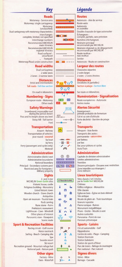
Detailed Road Network at 1:80,000 Scale
-
Motorways (including those under construction)
-
National, regional, and local roads
-
Clearly marked road numbers and route designations
-
Altitudes of passes displayed in metres
-
Kilometric distances between key points
-
-
Tourism & Cultural Highlights
-
Historical sites, ruins, monuments, and museums
-
Natural attractions and picturesque viewpoints
-
Beaches, ferry routes, and coastal features
-
-
Geographic & Administrative Details
-
International boundaries and key border crossings
-
Towns and villages marked according to population significance
-
Index of principal place names for quick referencing
-
-
Multilingual Key
-
Map legend in English, French, German, Italian, and Spanish
-
Place names shown in the local Greek spelling, matching road signage
-
📌 About the Region:
Located off Greece’s northwestern coast in the Ionian Sea, Corfu (Kerkyra) lies east of southern Italy and just southwest of Albania. Renowned for its lush landscapes, Venetian architecture, and turquoise waters, Corfu is a vibrant mix of ancient Greek history, medieval heritage, and Mediterranean leisure.
From the cultural treasures of Corfu Town (a UNESCO World Heritage site) to the island’s countless beaches, monasteries, and hilltop villages, this map helps you unlock every corner of the island and its nearby archipelago.
📐 Specifications:
| Feature | Details |
|---|---|
| Map Title | Michelin Map 140 – Corfu & the Ionian Islands |
| Scale | 1:80,000 |
| Unfolded Size | 1200 mm (W) × 1000 mm (H) |
| Format | Folded Paper Map |
| Publisher | Michelin Maps, France |
| Map Key Languages | English, French, German & others |
| Place Names | Local Greek (as seen on signage) |
🎯 Ideal For:
-
🧳 Travellers touring Corfu and nearby islands by car or motorbike
-
⛵ Holidaymakers navigating between islands by ferry or boat
-
🗺️ Map collectors and lovers of high-quality European cartography
-
📚 Students and educators studying Greek geography
-
🧭 Outdoor enthusiasts planning hikes or road trips
Note: The map edition and cover language (English, French, or German) may vary depending on the supplier, but the map content is identical across all versions.
📦 Ships from Australia – Available Now for Immediate Dispatch
From winding coastal drives to hidden hilltop villages, explore Corfu and the Ionian Islands in exquisite detail with Michelin’s expertly crafted map.
Frequently Asked Questions
Where can I buy the Corfu & Ionian Islands Michelin Map 140?
The Corfu & Ionian Islands Michelin Map 140 is available to buy online from Mapworld, Australia's largest map and geographic product retailer, with fast shipping Australia-wide.
Is the Corfu & Ionian Islands Michelin Map 140 in stock at Mapworld?
Mapworld maintains extensive stock across its map range and aims for fast dispatch. Orders placed before 2pm AEST on business days are typically dispatched the same day, with standard and express Australia-wide delivery options available.
What is Mapworld's returns policy?
Mapworld accepts returns on undamaged items in original condition. Contact Mapworld within 90 days of purchase to arrange a return or exchange.
Does Mapworld ship the Corfu & Ionian Islands Michelin Map 140 across Australia?
Yes, Mapworld ships Australia-wide. Standard shipping is a flat $7 rate, with free standard shipping on orders over $75. Express options are available at checkout. Most orders placed before 2pm AEST on weekdays are dispatched same day.
Related Items


© 2026 Mapworld. Website designed by Genie Media
X