- Australia ▾
- Topographic
▾
- Australia AUSTopo 250k (2025)
- Australia 50k Geoscience maps
- Australia 100k Geoscience maps
- Australia 250k Geoscience maps
- Australia 1:1m Geoscience maps
- New Zealand 50k maps
- New Zealand 250k maps
- New South Wales 25k maps
- New South Wales 50k maps
- New South Wales 100k maps
- Queensland 10k maps
- Queensland 25k maps
- Queensland 50k maps
- Queensland 100k maps
- Western Australia 25k maps
- Western Australia 50k maps
- Western Australia 100k maps
- Compasses
- Software
- GPS Systems
- International ▾
- Wall Maps
▾
- World
- Australia & New Zealand
- Countries, Continents & Regions
- Historical
- Vintage National Geographic
- Australian Capital Territory
- New South Wales
- Northern Territory
- Queensland
- South Australia
- Tasmania
- Victoria
- Western Australia
- Celestial
- Children's
- Mining & Resources
- Wine Maps
- Healthcare
- Postcode Maps
- Electoral Maps
- Nautical ▾
- Flags
▾
- Australian Flag Sets & Banners
- Flag Bunting
- Handwavers
- Australian National Flags
- Aboriginal Flags
- Torres Strait Islander Flags
- International Flags
- Flagpoles & Accessories
- Australian Capital Territory Flags
- New South Wales Flags
- Northern Territory Flags
- Queensland Flags
- South Australia Flags
- Tasmania Flags
- Victoria Flags
- Western Australia Flags
- Gifts ▾
- Globes ▾
Dear valued customer. Please note that our checkout is not supported by old browsers. Please use a recent browser to access all checkout capabilities


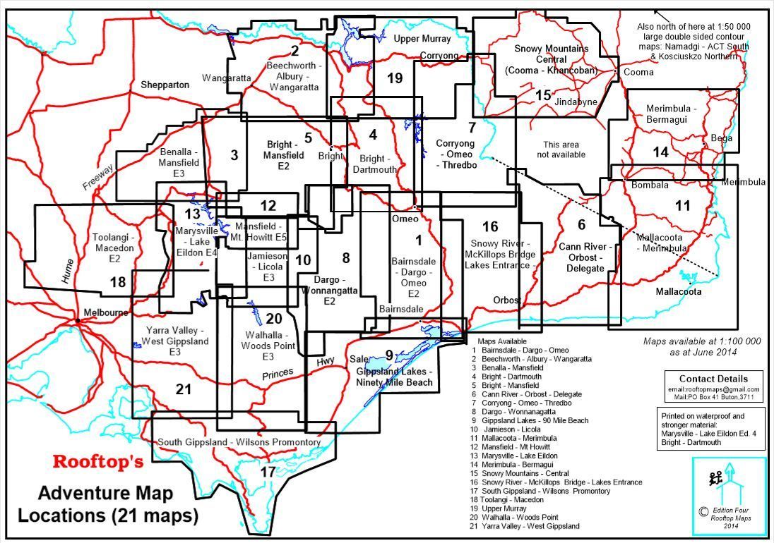
South Gippsland & Wilsons Promontory Adventure Map Rooftop
Sold Out
Afterpay is only available for orders between $50.00 and $1000.00 More info
Scale: 1:100,000 Main Map | 1:50,000 Enlargement | Optional Lamination
Includes Wilsons Prom Forest Activities Map | GPS-Plotted Tracks | Field Checked
🌿 Explore Victoria's Wild Southern Coastline in Detail
Stretching from Cape Liptrap to Tarra-Bulga, this Adventure Map by Rooftop offers unrivalled topographic detail and on-the-ground accuracy across South Gippsland and Wilsons Promontory — one of Victoria’s most pristine and sought-after natural regions.
This is not just a road map. It’s a comprehensive adventure planning tool, built with field-verified walking tracks, 4WD routes, campsites, key features, and natural landmarks — perfect for hikers, campers, and 4WD explorers who want to go beyond the bitumen.
Whether you're navigating the walking tracks of Wilsons Promontory National Park, heading for a remote beach, or plotting a drive through Korumburra, Foster, or Inverloch, this map gives you the precision and confidence to explore more deeply.
📍 Coverage Includes:
-
🏞️ Wilsons Promontory & Tarra-Bulga National Parks
-
🌊 Corner Inlet, Waratah Bay & Port Albert
-
🚙 Foster, Leongatha, Korumburra, Inverloch, Wonthaggi, and Yarram
-
🥾 Walkerville, Cape Liptrap, Yanakie, Fish Creek, Mirboo North & Woodside
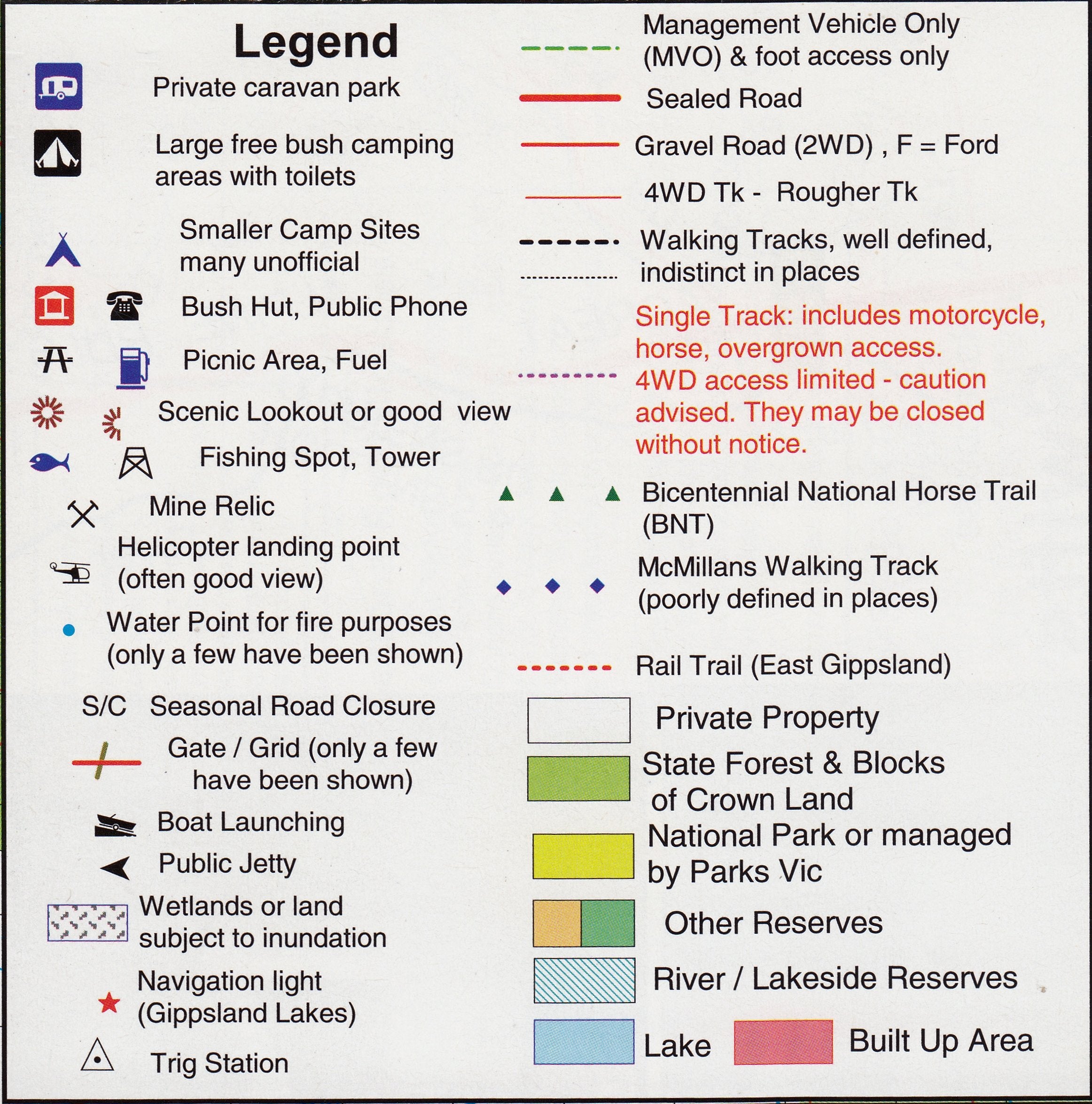
All roads, walking trails, and 4WD tracks have been GPS-plotted and many have been field-checked by the Rooftop team for accuracy. No guesswork here — just trails you can trust.
🔍 What’s Inside the Map?
🗺️ Main Map (Scale: 1:100,000)
-
Complete topographic layout of South Gippsland and the Prom
-
Park and reserve boundaries, rivers, creeks, campsites, and lookouts
-
Road classifications, town boundaries, and points of interest
🌲 Reverse Side: Wilsons Promontory Forest Activities Map (Scale: 1:50,000)
-
Field-checked walking tracks with detailed navigation notes
-
Overnight hike campsites and trail junctions clearly marked
-
Contour lines for elevation awareness and route planning
✨ Laminated Option for Reuse & Durability
Upgrade to a laminated edition for long-lasting use in the field or at home:
-
✅ Write-on/wipe-off surface – Use whiteboard markers to plot routes or notes
-
✅ Compatible with our Mark-It-Dots – Perfect for trip tracking or planning
-
✅ Tear- and water-resistant – Ideal for rugged use in wet or dusty conditions
-
🛠️ Note: Laminated versions are made by flattening the original folded map and sealing it between sheets of premium 80-micron gloss laminate. Minor fold lines may still be visible.
🧭 Perfect For:
-
🎒 Hikers & Bushwalkers – Plan single or multi-day hikes through Wilsons Prom
-
🚙 4WD Adventurers – Discover lesser-known tracks and access points across the region
-
🏕️ Campers & Caravaners – Locate the best spots to pitch a tent or park the van
-
📚 Teachers & Outdoor Educators – Use as a classroom tool or field resource
-
🗺️ Map Lovers & Collectors – A beautiful and functional addition to any collection
📏 Product Specifications
| Feature | Details |
|---|---|
| Map Title | South Gippsland & Wilsons Promontory Adventure Map |
| Publisher | Rooftop Maps |
| Map Scale | 1:100,000 (main) / 1:50,000 (Wilsons Prom enlargement) |
| Map Size | Approx. 700mm x 1000mm (variable by edition) |
| Track Detail | GPS-plotted & field-verified, includes 4WD, walking, and local roads |
| Material | Standard paper or laminated gloss (optional) |
| Finish (Laminated Option) | 80-micron double-sided gloss laminate – write-on/wipe-off |
| Printed In | Australia 🇦🇺 |
🛒 Add to Cart Today
If you're planning to hike, camp, or drive your way through Victoria’s spectacular southern wilderness, the South Gippsland & Wilsons Promontory Adventure Map is your essential guide. Field-tested, locally produced, and beautifully detailed.
Add to your cart now, and start preparing for your next outdoor escape — one map, many adventures.
Frequently Asked Questions
Where can I buy the South Gippsland & Wilsons Promontory Adventure Map Rooftop?
The South Gippsland & Wilsons Promontory Adventure Map Rooftop is available to buy online from Mapworld, Australia's largest map and geographic product retailer, with fast shipping Australia-wide.
Is the South Gippsland & Wilsons Promontory Adventure Map Rooftop in stock at Mapworld?
Mapworld maintains extensive stock across its map range and aims for fast dispatch. Orders placed before 2pm AEST on business days are typically dispatched the same day, with standard and express Australia-wide delivery options available.
What is Mapworld's returns policy?
Mapworld accepts returns on undamaged items in original condition. Contact Mapworld within 90 days of purchase to arrange a return or exchange.
Does Mapworld ship the South Gippsland & Wilsons Promontory Adventure Map Rooftop across Australia?
Yes, Mapworld ships Australia-wide. Standard shipping is a flat $7 rate, with free standard shipping on orders over $75. Express options are available at checkout. Most orders placed before 2pm AEST on weekdays are dispatched same day.
Related Items


© 2026 Mapworld. Website designed by Genie Media
X