- Australia ▾
- Topographic
▾
- Australia AUSTopo 250k (2025)
- Australia 50k Geoscience maps
- Australia 100k Geoscience maps
- Australia 250k Geoscience maps
- Australia 1:1m Geoscience maps
- New Zealand 50k maps
- New Zealand 250k maps
- New South Wales 25k maps
- New South Wales 50k maps
- New South Wales 100k maps
- Queensland 10k maps
- Queensland 25k maps
- Queensland 50k maps
- Queensland 100k maps
- Western Australia 25k maps
- Western Australia 50k maps
- Western Australia 100k maps
- Compasses
- Software
- GPS Systems
- International ▾
- Wall Maps
▾
- World
- Australia & New Zealand
- Countries, Continents & Regions
- Historical
- Vintage National Geographic
- Australian Capital Territory
- New South Wales
- Northern Territory
- Queensland
- South Australia
- Tasmania
- Victoria
- Western Australia
- Celestial
- Children's
- Mining & Resources
- Wine Maps
- Healthcare
- Postcode Maps
- Electoral Maps
- Nautical ▾
- Flags
▾
- Australian Flag Sets & Banners
- Flag Bunting
- Handwavers
- Australian National Flags
- Aboriginal Flags
- Torres Strait Islander Flags
- International Flags
- Flagpoles & Accessories
- Australian Capital Territory Flags
- New South Wales Flags
- Northern Territory Flags
- Queensland Flags
- South Australia Flags
- Tasmania Flags
- Victoria Flags
- Western Australia Flags
- Gifts ▾
- Globes ▾
Dear valued customer. Please note that our checkout is not supported by old browsers. Please use a recent browser to access all checkout capabilities


China ITMB Map
$24.95
Afterpay is only available for orders between $50.00 and $1000.00 More info
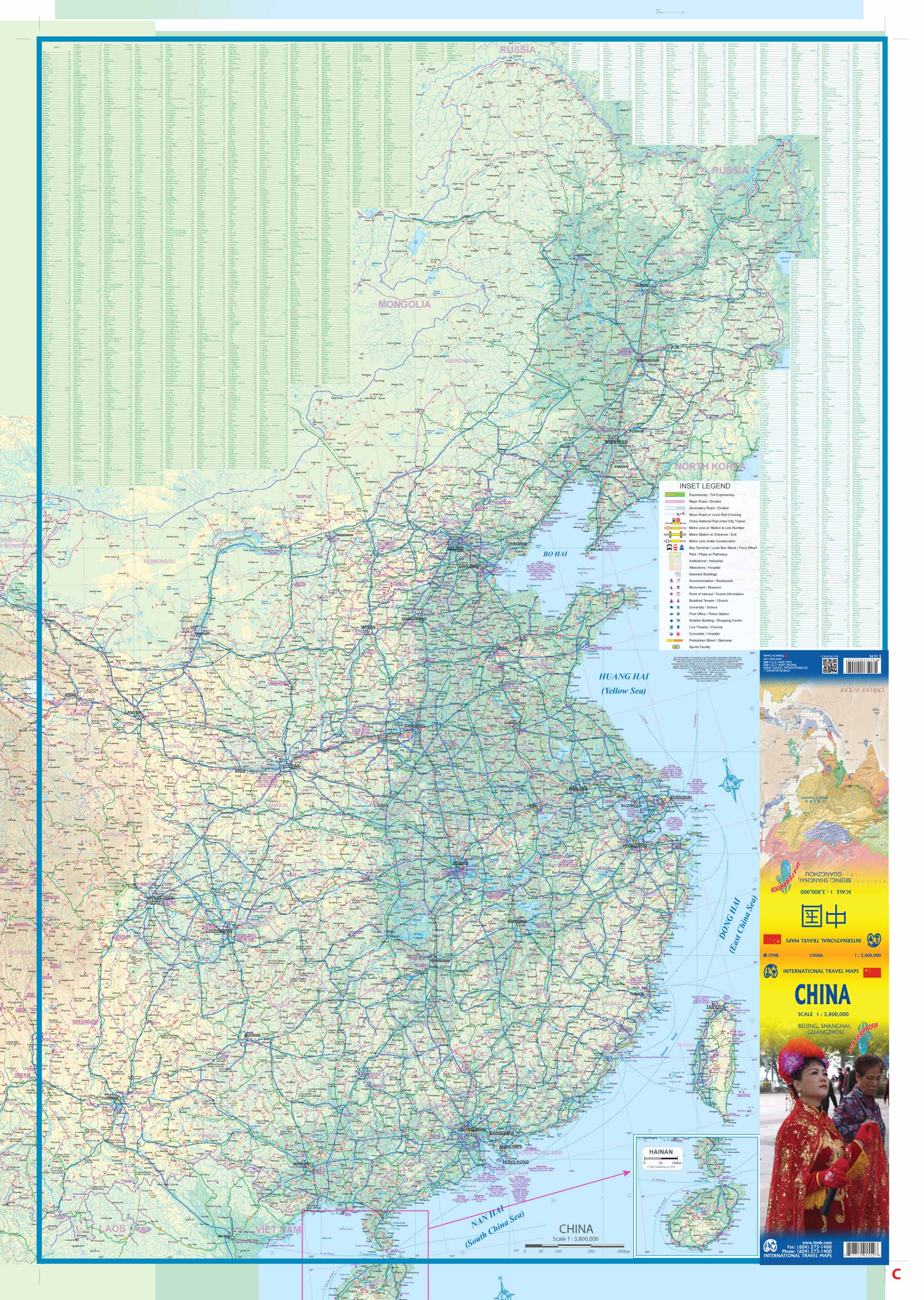
Scale: 1:3,800,000 | Size: 690 mm × 1000 mm | Waterproof & Tear-Resistant
Publisher: ITMB – International Travel Maps
🇨🇳 A Comprehensive Map of Modern China
Explore the breadth of modern China with this up-to-date, waterproof edition of ITMB’s China map—designed to reflect the country’s rapidly evolving infrastructure. This detailed map includes China's vast expressway network, expansive high-speed rail system, and all the major cities, mountain ranges, rivers, and borders with accuracy and clarity.
Printed on tear-resistant synthetic paper, this map is ideal for both travel and reference—equally suited for the armchair geographer or the intrepid explorer navigating China’s landscapes firsthand.
🧭 Key Features:
-
All major roadways and motorways clearly marked, including completed and under-construction segments
-
Rapid rail lines shown in red dashed lines, reflecting China’s extensive high-speed rail network
-
Inset city maps for Beijing and Shanghai on the reverse side
-
List of Top Tourist Attractions to help guide your travels or studies
-
Mountain ranges, rivers, and lakes clearly illustrated for terrain orientation
-
All provinces, autonomous regions, and major cities labeled with English romanization
🗺️ Political Notes & Border Depictions
This map includes politically sensitive regions shown according to de facto administrative control:
-
Northeastern areas disputed with India are shown under Indian administration
-
Northwestern territories, such as Aksai Chin, are shown under Chinese control
-
Taiwan is included geographically, though ITMB takes a neutral stance on its political status
This pragmatic approach offers clarity for travelers and educators while acknowledging the complexity of geopolitical boundaries.
💧 Laminated Option Available
We offer an optional laminated version of this map, perfect for:
-
Drawing with whiteboard markers
-
Adding Map Dots to mark places visited or planned
-
Protecting the map from moisture, wear, and accidental tearing
Laminated versions are created by carefully flattening the folded map and encapsulating it in high-grade 80-micron gloss laminate. Slight fold lines may remain visible due to the original fold.
📐 Map Specifications
| Feature | Detail |
|---|---|
| Scale | 1:3,800,000 |
| Dimensions | 690 mm (W) × 1000 mm (H) |
| Format | Folded map (laminated optional) |
| Material | Waterproof synthetic paper |
| Publisher | International Travel Maps (ITMB) |
Ideal For:
✔️ Tourists visiting China’s cities or countryside
✔️ Business professionals working in regional planning or logistics
✔️ Students and educators studying modern China
✔️ Rail enthusiasts tracking high-speed lines
✔️ Map collectors and world travelers
Durable, practical, and remarkably informative—this is one of the most comprehensive maps of China in print today.
Frequently Asked Questions
Where can I buy the China ITMB Map?
The China ITMB Map is available to buy online from Mapworld, Australia's largest map and geographic product retailer, with fast shipping Australia-wide.
Is the China ITMB Map in stock at Mapworld?
Mapworld maintains extensive stock across its map range and aims for fast dispatch. Orders placed before 2pm AEST on business days are typically dispatched the same day, with standard and express Australia-wide delivery options available.
What is Mapworld's returns policy?
Mapworld accepts returns on undamaged items in original condition. Contact Mapworld within 90 days of purchase to arrange a return or exchange.
Does Mapworld ship the China ITMB Map across Australia?
Yes, Mapworld ships Australia-wide. Standard shipping is a flat $7 rate, with free standard shipping on orders over $75. Express options are available at checkout. Most orders placed before 2pm AEST on weekdays are dispatched same day.
Related Items


© 2026 Mapworld. Website designed by Genie Media
X