- Australia ▾
- Topographic
▾
- Australia AUSTopo 250k (2025)
- Australia 50k Geoscience maps
- Australia 100k Geoscience maps
- Australia 250k Geoscience maps
- Australia 1:1m Geoscience maps
- New Zealand 50k maps
- New Zealand 250k maps
- New South Wales 25k maps
- New South Wales 50k maps
- New South Wales 100k maps
- Queensland 10k maps
- Queensland 25k maps
- Queensland 50k maps
- Queensland 100k maps
- Western Australia 25k maps
- Western Australia 50k maps
- Western Australia 100k maps
- Compasses
- Software
- GPS Systems
- International ▾
- Wall Maps
▾
- World
- Australia & New Zealand
- Countries, Continents & Regions
- Historical
- Vintage National Geographic
- Australian Capital Territory
- New South Wales
- Northern Territory
- Queensland
- South Australia
- Tasmania
- Victoria
- Western Australia
- Celestial
- Children's
- Mining & Resources
- Wine Maps
- Healthcare
- Postcode Maps
- Electoral Maps
- Nautical ▾
- Flags
▾
- Australian Flag Sets & Banners
- Flag Bunting
- Handwavers
- Australian National Flags
- Aboriginal Flags
- Torres Strait Islander Flags
- International Flags
- Flagpoles & Accessories
- Australian Capital Territory Flags
- New South Wales Flags
- Northern Territory Flags
- Queensland Flags
- South Australia Flags
- Tasmania Flags
- Victoria Flags
- Western Australia Flags
- Gifts ▾
- Globes ▾
Dear valued customer. Please note that our checkout is not supported by old browsers. Please use a recent browser to access all checkout capabilities


Children's Political Map of Africa 668 x 805mm
$69.95
or make 4 interest-free payments of
$17.49 AUD
fortnightly with
![]() More info
More info
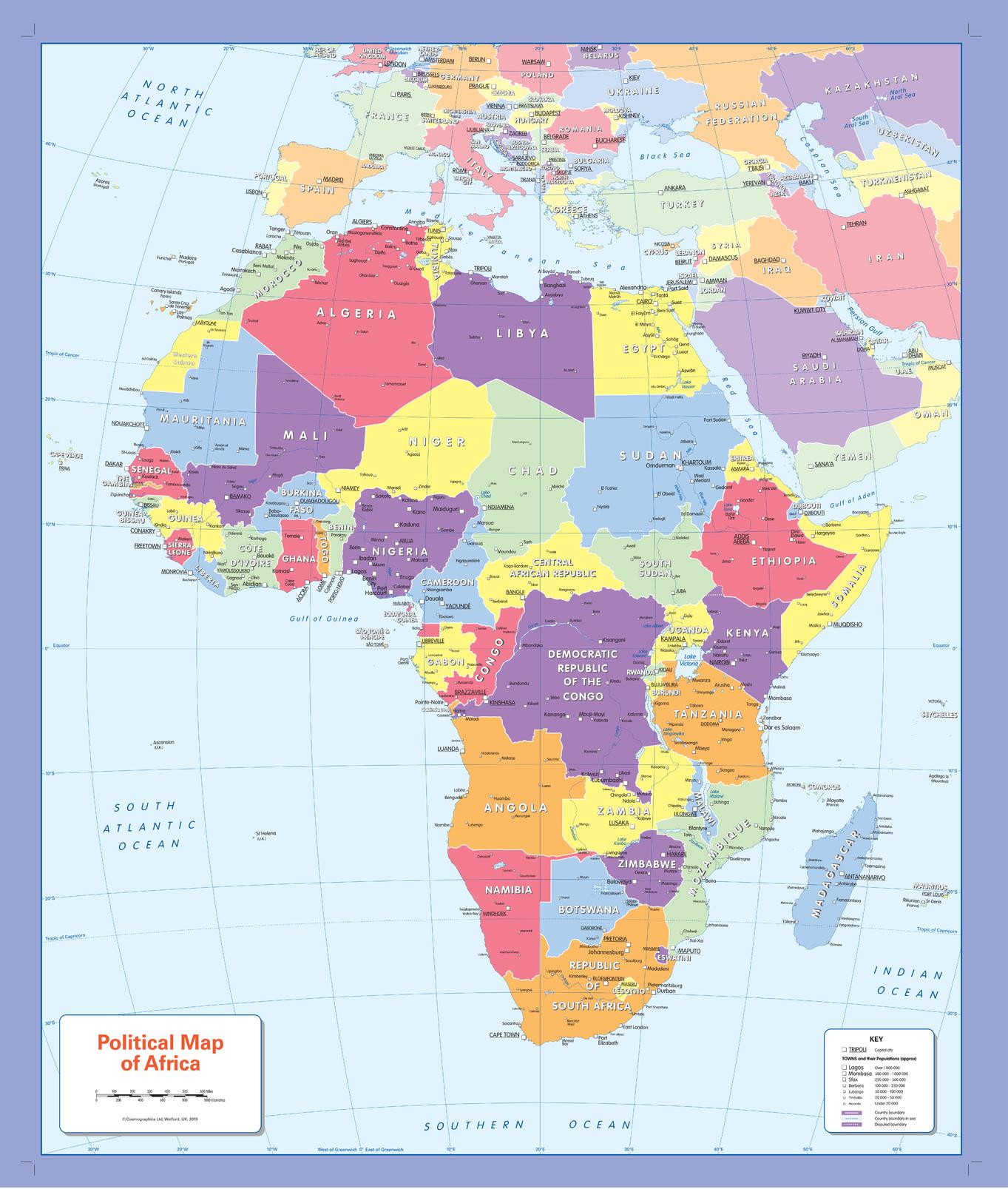
🗺️ Children’s Political Map of Africa
Size: 668 x 805 mm | Scale: 1:12,000,000 | Published: 2019
Bright, inclusive, and made for curious young minds—where every child can see the world clearly.
Help children explore the countries of Africa with this bright and accessible Children’s Political Wall Map, designed with inclusivity at its core. Specially created to accommodate all forms of colour blindness, this map ensures that every student in every classroom can see, understand, and enjoy the world around them.
Featuring clearly marked countries, capital cities, and a selection of major towns, this map offers a friendly introduction to Africa’s political geography. It’s a powerful visual tool for classrooms, homeschooling, or bedroom walls—wherever young minds are growing.
🧠 Key Educational Features
-
🌍 Country borders clearly defined using colour-blind–friendly contrast
-
🏙️ Selection of major cities and towns labelled in easy-to-read fonts
-
🧒 Designed specifically for children – simple layout, bold lines, no clutter
-
🎨 Inclusive colour palette – readable by children with any type of colour vision
-
📏 Large format makes it easy for group learning and display
-
🎓 Scale of 1:12,000,000 – ideal for early geography education
A map that makes Africa accessible to all learners—regardless of visual differences.
🖼️ Choose Your Format
| Format | Material & Finish | Best For |
|---|---|---|
| Paper | 160gsm matte paper | Perfect for framing under glass in classrooms or at home |
| Laminated | Encapsulated in 80-micron gloss laminate (both sides) – waterproof and whiteboard marker friendly | Great for hands-on learning in schools or learning spaces |
| Canvas | 395gsm HP Matte Artist’s Canvas with pigment inks – fade-resistant and durable | Premium wall décor for educational or home environments |
➕ Optional wooden hang rails available for laminated and canvas versions.
🪚 Optional Timber Hang Rails – Display-Ready Elegance
Upgrade your laminated or canvas map with handcrafted wooden hang rails:
-
🪵 Natural wood finish, satin-lacquered for timeless appeal
-
🧵 Top rail includes a cord for easy wall hanging
-
🖐️ Expertly mounted by our framer for a clean, polished look
-
⏳ Please allow up to 10 working days for timber hang rail assembly and delivery
Display the map as a centrepiece of learning—with style and simplicity.
📐 Map Specifications
| Feature | Details |
|---|---|
| Title | Children’s Political Map of Africa |
| Published | 2019 |
| Size | 668 mm (W) x 805 mm (H) |
| Scale | 1:12,000,000 |
| Map Type | Political (with capital cities & towns) |
| Design Focus | Child-friendly, colour-blind inclusive |
| Print Origin | Printed and finished in Australia |
| Optional Extras | Timber hang rails (Canvas & Laminated only) |
💡 Why This Map Is Perfect for Young Learners
✅ Geography made fun – Easy-to-read and visually engaging for young students
✅ Inclusive by design – Created to work with all forms of colour blindness
✅ Curriculum-aligned – Helps children learn about countries, capitals, and borders
✅ Durable & long-lasting – Fade-resistant, waterproof, and ready for classroom life
✅ A thoughtful gift – Ideal for educators, homeschoolers, or map-loving kids
Give every child the chance to explore Africa’s countries, cities, and story—with a map designed to include everyone.
📦 Shipping Information
-
📄 Paper & Laminated formats: Ships within 1–2 business days
-
🖼️ Canvas & Hang Rail versions: Please allow 7–10 business days for custom framing
🛒 Add to Cart – Inspire Young Explorers Today
Promote inclusivity and curiosity with this educational, child-friendly political map of Africa—designed for the way kids learn best.
Frequently Asked Questions
What are the dimensions of the Children's Political Map of Africa 668 x 805mm?
Mapworld wall maps range from standard 700×1000mm to large-format 1000×1430mm Supermaps. The exact dimensions for this map are shown in the product title. Where multiple sizes are available, select your preferred size when adding to cart.
Is this wall map available laminated?
Many Mapworld wall maps are available in paper, laminated, or framed finishes. Check the product options when adding to cart. Laminated maps are wipe-clean and more durable.
Is this the latest edition?
Mapworld stocks the most current editions available from all publishers. Edition year is shown in the product title where applicable. Mapworld updates its catalogue as new editions are released.
Can I write on or pin this wall map?
Laminated wall maps can be written on with whiteboard markers and wiped clean. Paper maps can be pinned on a corkboard. Choose a laminated option for a writeable surface.
Does Mapworld ship the Children's Political Map of Africa 668 x 805mm across Australia?
Yes, Mapworld ships Australia-wide. Standard shipping is a flat $7 rate, with free standard shipping on orders over $75. Express options are available at checkout. Most orders placed before 2pm AEST on weekdays are dispatched same day.
Related Items


© 2026 Mapworld. Website designed by Genie Media
X