- Australia ▾
- Topographic
▾
- Australia AUSTopo 250k (2025)
- Australia 50k Geoscience maps
- Australia 100k Geoscience maps
- Australia 250k Geoscience maps
- Australia 1:1m Geoscience maps
- New Zealand 50k maps
- New Zealand 250k maps
- New South Wales 25k maps
- New South Wales 50k maps
- New South Wales 100k maps
- Queensland 10k maps
- Queensland 25k maps
- Queensland 50k maps
- Queensland 100k maps
- Compasses
- Software
- GPS Systems
- Orienteering
- International ▾
- Wall Maps
▾
- World
- Australia & New Zealand
- Countries, Continents & Regions
- Historical
- Vintage National Geographic
- Australian Capital Territory
- New South Wales
- Northern Territory
- Queensland
- South Australia
- Tasmania
- Victoria
- Western Australia
- Celestial
- Children's
- Mining & Resources
- Wine Maps
- Healthcare
- Postcode Maps
- Electoral Maps
- Nautical ▾
- Flags
▾
- Australian Flag Sets & Banners
- Flag Bunting
- Handwavers
- Australian National Flags
- Aboriginal Flags
- Torres Strait Islander Flags
- International Flags
- Flagpoles & Accessories
- Australian Capital Territory Flags
- New South Wales Flags
- Northern Territory Flags
- Queensland Flags
- South Australia Flags
- Tasmania Flags
- Victoria Flags
- Western Australia Flags
- Gifts ▾
- Globes ▾
Dear valued customer. Please note that our checkout is not supported by old browsers. Please use a recent browser to access all checkout capabilities
Children's World Wall Map by Collins
$59.95 $69.95
or make 4 interest-free payments of
$14.99 AUD
fortnightly with
![]() More info
More info
Children’s Illustrated World Map – A Colourful Journey Around the Globe
A Fun and Educational Introduction to Geography for Young Explorers (Ages 4–8)
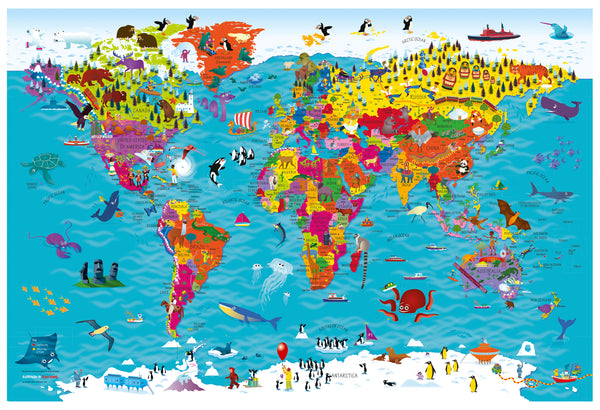
Ignite your child’s curiosity and sense of adventure with this highly illustrated pictorial world map, thoughtfully designed to introduce young minds to the wonders of our planet. Created by talented illustrator Steve Evans, this vibrant map transforms geography into an exciting, accessible experience for children aged 4 to 8 years.
Beautifully detailed and brimming with colour, the map highlights countries and their capital cities, while lively illustrations bring the world to life with national symbols, cultural traditions, foods, animals, buildings, birds, and sports. Every corner of the map is packed with engaging visuals that spark imagination and encourage learning through play.
🎨 Why Kids (and Parents) Love This Map:
-
A Visual Feast for Young Learners
Colourful and fun, the illustrations help children make connections between geography and culture in a meaningful way. -
Teaches Geography and Global Awareness
Includes country names and capitals, helping children start to recognise continents, countries, and the diversity of people and places around the world. -
The Perfect First Map
A gentle and engaging introduction to world maps, perfect for young learners in classrooms, playrooms, or bedrooms.
📏 Available Sizes:
-
Large Map: 915 mm (W) × 610 mm (H)
-
Supermap Edition: 1450 mm (W) × 990 mm (H)
Choose the size that best fits your space—both options provide crisp, vibrant illustrations and clear text designed with children in mind.
🖨️ Three Premium Finish Options:
✅ 1. Heavyweight 160 gsm Paper (Unlaminated)
Perfect for framing under glass, this matte paper finish provides brilliant colour reproduction and is great for educational and decorative display.
✅ 2. Gloss-Laminated (Encapsulated)
Fully sealed in two layers of 80-micron gloss laminate, this version is tear-resistant, waterproof, and wipe-clean—ideal for classrooms, kids’ rooms, or any space where durability is key.
✅ 3. HP Professional Matte Canvas (395 gsm)
Printed on durable canvas using fade-resistant, pigment-based inks, this version delivers rich texture and exceptional longevity. A gallery-quality finish that makes the map a lasting centrepiece in any child's space.
🪵 Optional Timber Hanging Rails
Make your map easy to display with our optional natural timber hang rails, lacquered for a smooth finish and fitted top and bottom. The hanging cord allows for quick, hassle-free installation on any wall.
⏳ Please allow up to 10 working days for canvas maps with hang rails, as each piece is custom-assembled by our framer.
👧🧒 Perfect For:
-
Curious kids aged 4–8
-
Classrooms and early learning centres
-
Parents and grandparents looking for educational gifts
-
Decorating children's bedrooms, playrooms, or study areas
-
Homeschooling families
-
Anyone wanting to spark a child’s love for travel and global culture
🌟 Inspire a Love of Learning and the World
This Children’s Illustrated World Map is more than just wall art—it’s a gateway to discovery, sparking questions, conversations, and dreams of adventure. Whether you're gifting it, decorating a room, or adding to a homeschool curriculum, it's an investment in wonder, learning, and connection.


