- Australia ▾
- Topographic
▾
- Australia AUSTopo 250k (2025)
- Australia 50k Geoscience maps
- Australia 100k Geoscience maps
- Australia 250k Geoscience maps
- Australia 1:1m Geoscience maps
- New Zealand 50k maps
- New Zealand 250k maps
- New South Wales 25k maps
- New South Wales 50k maps
- New South Wales 100k maps
- Queensland 10k maps
- Queensland 25k maps
- Queensland 50k maps
- Queensland 100k maps
- Western Australia 25k maps
- Western Australia 50k maps
- Western Australia 100k maps
- Compasses
- Software
- GPS Systems
- International ▾
- Wall Maps
▾
- World
- Australia & New Zealand
- Countries, Continents & Regions
- Historical
- Vintage National Geographic
- Australian Capital Territory
- New South Wales
- Northern Territory
- Queensland
- South Australia
- Tasmania
- Victoria
- Western Australia
- Celestial
- Children's
- Mining & Resources
- Wine Maps
- Healthcare
- Postcode Maps
- Electoral Maps
- Nautical ▾
- Flags
▾
- Australian Flag Sets & Banners
- Flag Bunting
- Handwavers
- Australian National Flags
- Aboriginal Flags
- Torres Strait Islander Flags
- International Flags
- Flagpoles & Accessories
- Australian Capital Territory Flags
- New South Wales Flags
- Northern Territory Flags
- Queensland Flags
- South Australia Flags
- Tasmania Flags
- Victoria Flags
- Western Australia Flags
- Gifts ▾
- Globes ▾
Dear valued customer. Please note that our checkout is not supported by old browsers. Please use a recent browser to access all checkout capabilities


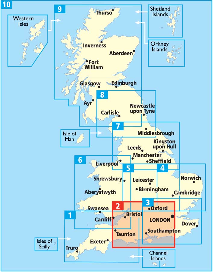
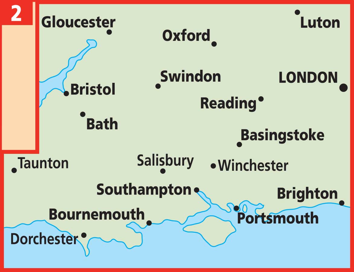
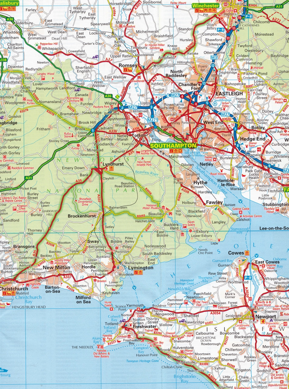
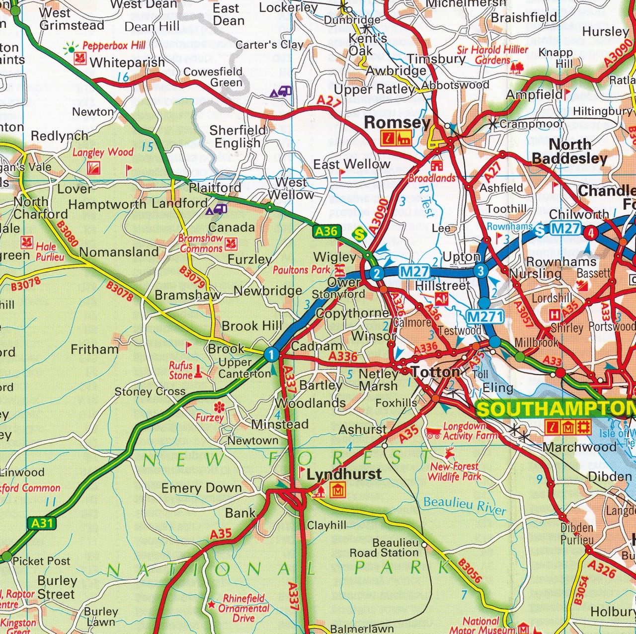
Central Southern England AA Road Map 2
$19.95
Afterpay is only available for orders between $50.00 and $1000.00 More info
Latest 2024 Edition | Scale: 1:200,000 (3 miles to 1 inch)
Unfolded Size: 1200 mm (w) x 980 mm (h)
Format: Folded Paper Map with Durable Cover
🚘 Your Perfect Road Trip Companion
Covering the heart of Southern England with remarkable clarity and detail, this Central Southern England AA Road Map 2 is a must-have for anyone planning to explore the region by road. From the coastlines of Bournemouth and Portsmouth to the historic streets of Bath and Oxford, this map ensures you’ll navigate with confidence and efficiency.
Produced by the AA (Automobile Association) — the UK’s trusted authority in motoring and travel — this map offers a perfect blend of practical road detail, tourist insight, and durable usability. Whether you’re planning a scenic drive, touring in a campervan, or simply need a reliable backup to your sat-nav, this map delivers.
📍 Coverage Area
This map focuses on the central southern region of England, including:
-
Bristol, Bath & Gloucestershire
-
Reading, Oxford & Berkshire
-
Southampton, Portsmouth & Hampshire
-
Bournemouth, Poole & Dorset
-
Wiltshire, Somerset, and parts of the Cotswolds
🧭 Key Map Features
| 🛠️ Feature | 📝 Description |
|---|---|
| Scale | 1:200,000 (3 miles to 1 inch) |
| Road Types | Motorways, dual carriageways, A-roads, B-roads, toll routes, narrow roads |
| City Centre Insets | CBD maps of Southampton, Portsmouth, Reading, Oxford, Bristol, Bournemouth, Bath, and Basingstoke |
| Tourist Information | National Trust, English Heritage, and other key cultural attractions marked |
| Natural Highlights | National Parks and scenic routes prominently shown |
| Caravan & Camping Sites | Clearly indicated — ideal for campervan and RV travellers |
| Speed Camera Locations | Updated, including cameras with speed limits |
| Place Name Index | Comprehensive and alphabetically organized |
| Durable Cover | Weather-resistant protective folder keeps your map safe and dry |
🌄 What's New in This Edition (2024)
-
Fully updated road and motorway network
-
Revised speed camera locations and speed limit indicators
-
Enhanced tourist attraction symbols and campsite coverage
-
Cleaner cartographic style with improved readability
🎯 Who Is This Map For?
| 👤 Ideal For | 🌟 Why They’ll Love It |
|---|---|
| Road trippers & car tourers | Easy-to-follow layout, speed cameras marked, top sights highlighted |
| Campervan & motorhome users | Caravan and camping symbols clearly visible |
| UK staycationers | Discover lesser-known destinations and national parks |
| Travel planners & route designers | Ideal for laying out a comprehensive holiday or driving plan |
| Heritage and culture seekers | Find castles, gardens, historic sites and walking trails with ease |
| Cyclists & walkers (for planning) | Great for mapping out quiet back roads and scenic countryside routes |
📦 Product Specifications
| 🔍 Specification | 📐 Details |
|---|---|
| Edition | 2024 |
| Scale | 1:200,000 (3 miles to 1 inch) |
| Format | Folded paper map |
| Unfolded Size | 1200 mm (w) x 980 mm (h) |
| Publisher | AA (Automobile Association UK) |
| Language | English |
| Cover | Weather-resistant protective folder |
| ISBN | 9780749578916 |
🛒 Why Buy This Map?
-
✅ Trusted AA quality – accurate, authoritative, and beautifully clear
-
✅ Ideal for real-world navigation – especially when devices fail or lose signal
-
✅ More than just roads – packed with ideas for walks, attractions, and day trips
-
✅ Durable & practical – built to last in glove compartments, backpacks, or map cases
-
✅ Supports British tourism – discover overlooked gems across the South
🕓 Quick Dispatch from Australia
This item is in stock and ships next business day from our Australian warehouse.
✈️ Perfect for travellers, planners, campers, or anyone who wants to explore the best of England’s South with clarity and confidence.
Frequently Asked Questions
What area does the Central Southern England AA Road Map 2 cover?
The Central Southern England AA Road Map 2 provides road coverage of the region named in the product title. The map covers major cities, highways, towns, and regional roads, with inset city maps for key urban centres where applicable.
Is the Central Southern England AA Road Map 2 up to date?
Yes, this is the current edition. Mapworld stocks the most current editions from all major publishers, updated to reflect new roads and infrastructure.
What size is this map when unfolded?
Folded maps from Mapworld's range are compact and portable. Most standard folded road or travel maps open to between A1 (594 × 841mm) and A0 (841 × 1189mm) when fully unfolded, and fold down to approximately A4 or smaller for easy storage in a glove box, bag, or backpack.
Is the Central Southern England AA Road Map 2 in stock at Mapworld?
Mapworld maintains extensive stock across its map range and aims for fast dispatch. Orders placed before 2pm AEST on business days are typically dispatched the same day, with standard and express Australia-wide delivery options available.
Does Mapworld ship the Central Southern England AA Road Map 2 across Australia?
Yes, Mapworld ships Australia-wide. Standard shipping is a flat $7 rate, with free standard shipping on orders over $75. Express options are available at checkout. Most orders placed before 2pm AEST on weekdays are dispatched same day.
Related Items


© 2026 Mapworld. Website designed by Genie Media
X