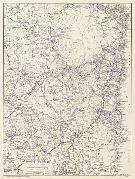
Central Eastern New South Wales — Motorist’s & Hiker’s Wall Map by Robinson (1932)
Gravel bends, timber bridges, picnic grounds and bush trails—this 1932 H.E.C. Robinson classic gathers a 100-kilometre radius of Sydney into one clear, adventure-ready portrait. From Newcastle down the coast to Batemans Bay, and west across the tablelands towards Young, main and minor roads, tracks and walking trails lace the landscape. Camp sites and beauty spots are called out with the confidence of an era when a weekend meant canvas tents, billy tea, and a full tank. Part chart, part invitation, it puts the 1930s spirit of motoring and bushwalking back on your wall.
Why it captivates
-
Early road-trip clarity — main & minor roads and tracks & trails rendered in Robinson’s crisp interwar drafting.
-
100-km Sydney sphere — the weekend playground mapped in one glance: Newcastle → Batemans Bay, west to Young.
-
Camping culture, mapped — camping areas and recreation sites captured at the dawn of mass motoring.
-
Scholarly & beautiful — balanced lettering, neatlines and hierarchy that read cleanly from across the room.
What you’ll see
-
Comprehensive road network with graded distinctions for main, minor and local roads.
-
Walking tracks & bush trails marked for hikers and ramblers.
-
Camping areas and recreation reserves called out for trip planning.
-
Coast, rivers, ridgelines & townships set in a legible regional structure.
-
Period finish preserved — titlework, neatline and disciplined type for names and features.
A richer historical frame
The early 1930s transformed leisure in New South Wales: affordable cars, rail-link weekends, and a flourishing bushwalking scene. H.E.C. Robinson distilled that momentum into maps you could fold into a glovebox or pin to a wall—precise enough to navigate, composed enough to keep. This 1932 edition sits in that tradition, fixing a moment when roads, tracks and campgrounds stitched city and bush into one lived geography.
Choose your finish
Heavyweight Paper (160 gsm matte)
Best for: framing under glass in studies and living spaces
Look & feel: non-glare matte that preserves fine linework and small labels
Laminated (true encapsulation)
Best for: classrooms, clubs, libraries and shared spaces
Build: sealed edge-to-edge between two 80-micron gloss sheets
Benefit: wipe-clean, durable, moisture-resistant
Laminated + Timber Hang Rails (Ready to hang)
What you get: encapsulated print plus natural lacquered timber rails top & bottom with a discreet hanging cord
Where it shines: foyers, motoring clubs, schools—polished look with everyday toughness
Install: arrives ready to hang (just add a wall hook)
Lead time: please allow up to 10 working days for professional rail mounting
Archival Canvas (395 gsm HP Professional Matte)
Best for: premium interiors, clubrooms and galleries
Print system: pigment-based, fade-resistant inks for long display life
Presence: textured surface adds warmth and museum-style depth
Canvas + Timber Hang Rails (Gallery-ready)
What you get: canvas fitted with natural timber rails top & bottom, matching cord
Where it shines: statement walls, curated heritage displays
Install: ready to hang; single-hook friendly
Lead time: please allow up to 10 working days for rail mounting
Sizes (W × H)
-
730 × 970 mm — tall, portrait presence with generous route and campsite detail
At-a-glance materials
| Option | Best for | Key benefits |
|---|---|---|
| Paper (160 gsm) | Framing under glass | Matte clarity; crisp period detail |
| Laminated (encapsulated) | Busy/shared spaces | Wipeable; tough; edge-to-edge protection |
| Laminated + Rails | Ready-to-hang public display | Professional mount; easy install; durable |
| Canvas (395 gsm) | Premium display | Archival inks; textured depth; gallery appeal |
| Canvas + Rails | Gallery-ready feature | Period-true presentation; simple hanging |
Styling ideas
-
Touring wall: add a caption card marking family routes, camps and favourite lookouts.
-
Club foyer or library: choose Laminated + Rails for a polished, robust display.
-
Study or den: canvas with rails above timber cabinetry for warm interwar character.
-
Planning nook: frame the paper edition; keep a magnifier handy for minor roads and trails.
Specifications
| Detail | Description |
|---|---|
| Title | Central Eastern New South Wales — Motorist’s & Hiker’s Wall Map |
| Edition | 1932 |
| Cartographer/Publisher | H.E.C. Robinson |
| Region | ~100-km radius of Sydney; Newcastle to Batemans Bay, west towards Young |
| Type | Motorist’s & hiker’s regional map |
| Content Highlights | Main & minor roads; tracks & walking trails; camping areas; towns; rivers; period lettering & neatline |
| Finishes | Paper; Laminated (encapsulated); Laminated + Timber Rails; Canvas; Canvas + Timber Rails |
| Lead Time (Rails) | Up to 10 working days (laminated or canvas with rails) |
| Orientation | Portrait |
| Size | 730 × 970 mm (W × H) |
| Production | Made in Australia |
Who it’s for
-
Bushwalkers, hikers and vintage motoring enthusiasts
-
Councils, libraries & museums curating 1930s leisure and travel
-
Collectors & interior designers seeking authentic interwar cartography with road-trip charm
Claim your wall. Choose Paper for crisp, frame-ready clarity. Go Laminated + Timber Rails for tough, ready-to-hang polish. Step up to Archival Canvas + Timber Hang Rails for gallery weight. Printed in Australia with pigment-based, fade-resistant inks. Built to last. Hang it. Live with it. Keep the weekend close.


