- Australia ▾
- Topographic
▾
- Australia AUSTopo 250k (2024)
- Australia 50k Geoscience maps
- Australia 100k Geoscience maps
- Australia 250k Geoscience maps
- Australia 1.1m Geoscience maps
- New Zealand 50k maps
- New Zealand 250k maps
- New South Wales 25k maps
- New South Wales 50k maps
- New South Wales 100k maps
- Queensland 10k maps
- Queensland 25k maps
- Queensland 50k maps
- Queensland 100k maps
- Compasses
- Software
- GPS Systems
- Orienteering
- International ▾
- Wall Maps
▾
- World
- Australia & New Zealand
- Countries, Continents & Regions
- Historical
- Vintage National Geographic
- Australian Capital Territory
- New South Wales
- Northern Territory
- Queensland
- South Australia
- Tasmania
- Victoria
- Western Australia
- Celestial
- Children's
- Mining & Resources
- Wine Maps
- Healthcare
- Postcode Maps
- Electoral Maps
- Nautical ▾
- Flags
▾
- Australian Flag Sets & Banners
- Flag Bunting
- Handwavers
- Australian National Flags
- Aboriginal Flags
- Torres Strait Islander Flags
- International Flags
- Flagpoles & Accessories
- Australian Capital Territory Flags
- New South Wales Flags
- Northern Territory Flags
- Queensland Flags
- South Australia Flags
- Tasmania Flags
- Victoria Flags
- Western Australia Flags
- Gifts ▾
- Globes ▾
Dear valued customer. Please note that our checkout is not supported by old browsers. Please use a recent browser to access all checkout capabilities
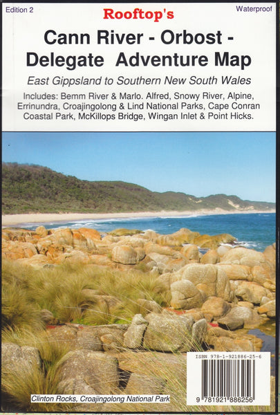
Cann River - Oborst Adventure Map Rooftop
$14.95 $15.95
Afterpay is only available for orders between $50.00 and $1000.00 More info
Explore Far East Gippsland’s Wildest Landscapes – Alpine Trails, Rainforests & Coastal Parks
Waterproof & Tear-Resistant | GPS-Plotted Tracks | Detailed Inset Maps & Campgrounds
Map Size: 700 mm x 1000 mm
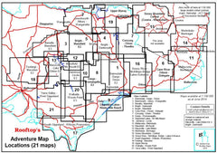
From the tranquil inlets of Cape Conran to the dramatic alpine routes around McKillops Bridge, the Cann River – Oborst Adventure Map by Rooftop Maps is your gateway to the raw and rugged beauty of Far East Gippsland. This high-detail, GPS-verified map covers a vast sweep of remote Victoria, ideal for 4WD explorers, hikers, kayakers, and nature-lovers alike.
🗺️ Main Coverage Areas
-
🌲 Alpine National Park
-
🌿 Errinundra National Park
-
🏕️ Croajingolong National Park
-
🏖️ Cape Conran Coastal Park
-
🌊 Bemm River, Marlo & Sydenham Inlet
-
🏞️ McKillops Bridge, Wingan Inlet & Point Hicks
-
🌳 Lind National Park & State Forests
Inset Maps on Reverse Side Include:
✔️ Sydenham Inlet Access
✔️ Tamboon Inlet Access
✔️ Cape Conran Coastal Park & Camping Area
✔️ Huts & Waterfalls – Far East Gippsland
✔️ Attractions Around Bendoc
✔️ Neville Falls – Princes Highway Map
✔️ Suggan Buggan to Willis Map
✔️ Coastal Access: Cape Conran to Wingan Inlet
Each inset is meticulously drawn and packed with local insights, including track access, campsites, waterfalls, lookouts, and hidden bush huts.
✅ Key Features & Benefits
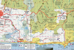
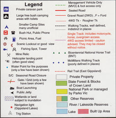
🧭 Accurate GPS-Mapped Roads & Tracks
Every track, trail and road within the map area is plotted using real-time GPS mapping technology for the most reliable navigation possible—on and off-road.
💧 Waterproof & Tear-Resistant Paper
Ideal for all-weather adventures. Whether it’s rain in the rainforest or dust on the dash, this durable map stands up to the elements.
⛺ Campsites & Tourist Attractions Mapped
Find your perfect overnight stop or day hike with clearly marked parks, reserves, campgrounds, and natural landmarks.
🛠️ Optional Lamination Available
Upgrade to a laminated version, which lets you:
-
Draw routes and notes with whiteboard marker
-
Apply map dots to mark visited or planned destinations
-
Wipe clean after each adventure
Note: Laminated versions are flattened and encapsulated in high-quality 80-micron gloss laminate. Slight fold lines from the original may still be visible.
📐 Specifications
| Feature | Detail |
|---|---|
| Publisher | Rooftop Maps |
| Edition | Latest available |
| Size | 700 mm x 1000 mm (folded or flat) |
| Material | Waterproof & tear-resistant paper |
| Lamination Option | Yes – 80-micron gloss encapsulation |
| Printing | Full-colour, GPS-accurate mapping |
Ideal For:
✔️ 4WD explorers heading into remote bushland
✔️ Hikers and bushwalkers looking for topographic accuracy
✔️ Fishers and kayakers exploring inlets and river mouths
✔️ National Park campers and off-grid adventurers
✔️ Anyone planning a road trip through Far East Gippsland
🛒 Add to Cart Now – and experience one of Victoria’s most diverse and remote regions with confidence. The Cann River – Oborst Adventure Map by Rooftop is not just a map—it’s your blueprint to the ultimate East Gippsland escape.


