- Australia ▾
- Topographic
▾
- Australia AUSTopo 250k (2025)
- Australia 50k Geoscience maps
- Australia 100k Geoscience maps
- Australia 250k Geoscience maps
- Australia 1:1m Geoscience maps
- New Zealand 50k maps
- New Zealand 250k maps
- New South Wales 25k maps
- New South Wales 50k maps
- New South Wales 100k maps
- Queensland 10k maps
- Queensland 25k maps
- Queensland 50k maps
- Queensland 100k maps
- Western Australia 25k maps
- Western Australia 50k maps
- Western Australia 100k maps
- Compasses
- Software
- GPS Systems
- International ▾
- Wall Maps
▾
- World
- Australia & New Zealand
- Countries, Continents & Regions
- Historical
- Vintage National Geographic
- Australian Capital Territory
- New South Wales
- Northern Territory
- Queensland
- South Australia
- Tasmania
- Victoria
- Western Australia
- Celestial
- Children's
- Mining & Resources
- Wine Maps
- Healthcare
- Postcode Maps
- Electoral Maps
- Nautical ▾
- Flags
▾
- Australian Flag Sets & Banners
- Flag Bunting
- Handwavers
- Australian National Flags
- Aboriginal Flags
- Torres Strait Islander Flags
- International Flags
- Flagpoles & Accessories
- Australian Capital Territory Flags
- New South Wales Flags
- Northern Territory Flags
- Queensland Flags
- South Australia Flags
- Tasmania Flags
- Victoria Flags
- Western Australia Flags
- Gifts ▾
- Globes ▾
Dear valued customer. Please note that our checkout is not supported by old browsers. Please use a recent browser to access all checkout capabilities


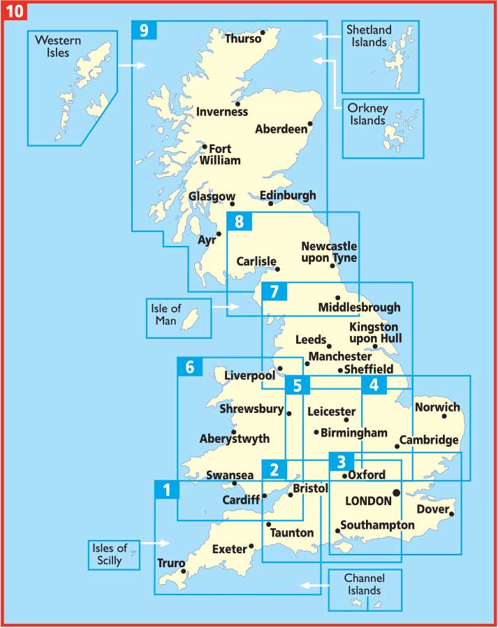
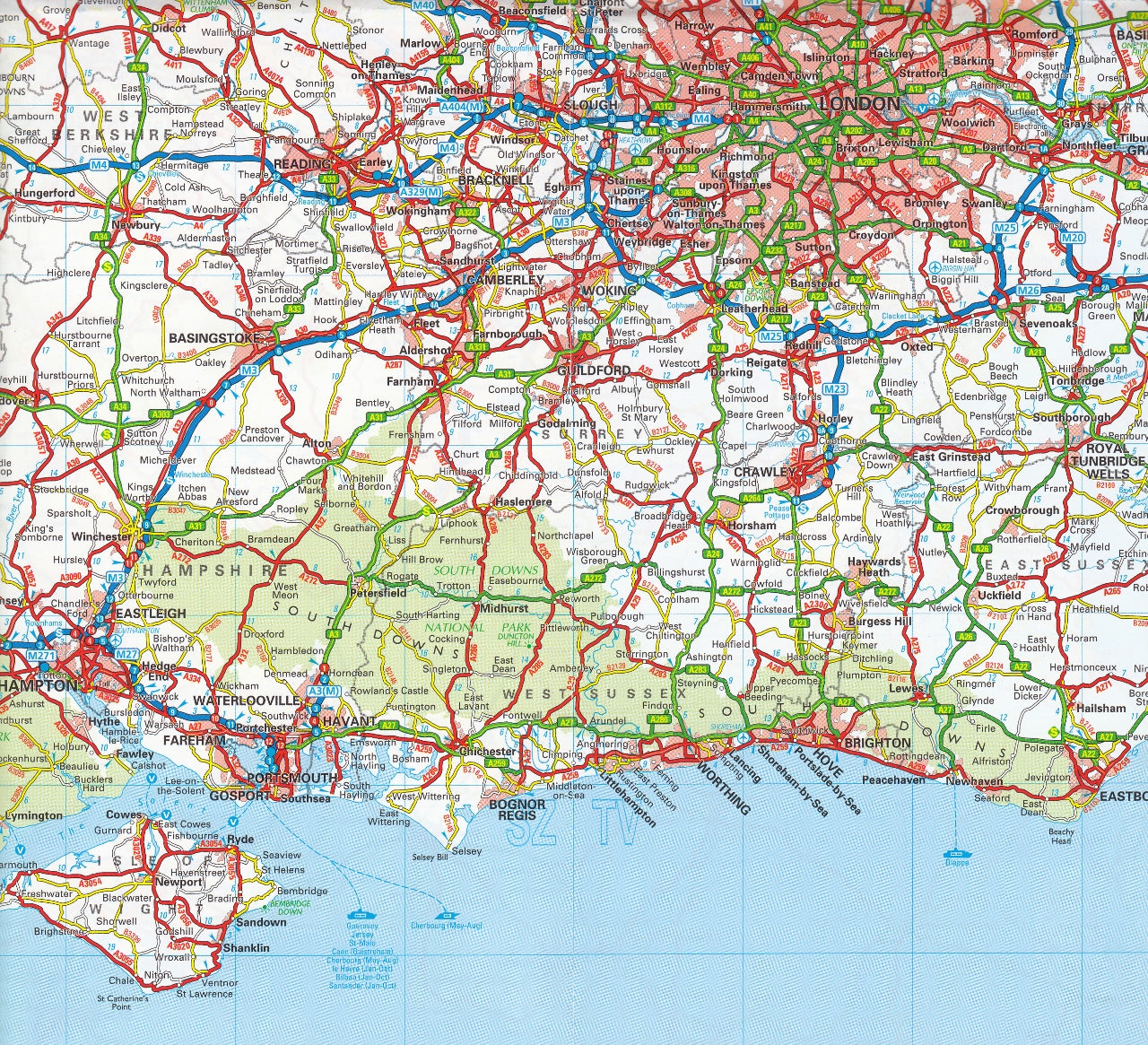
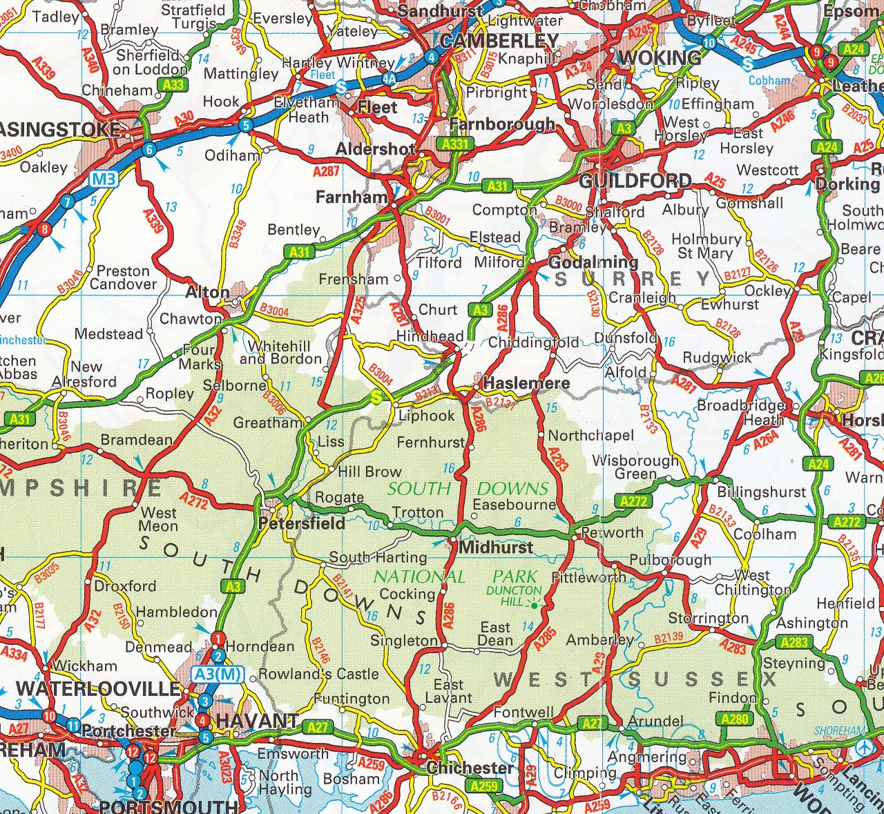
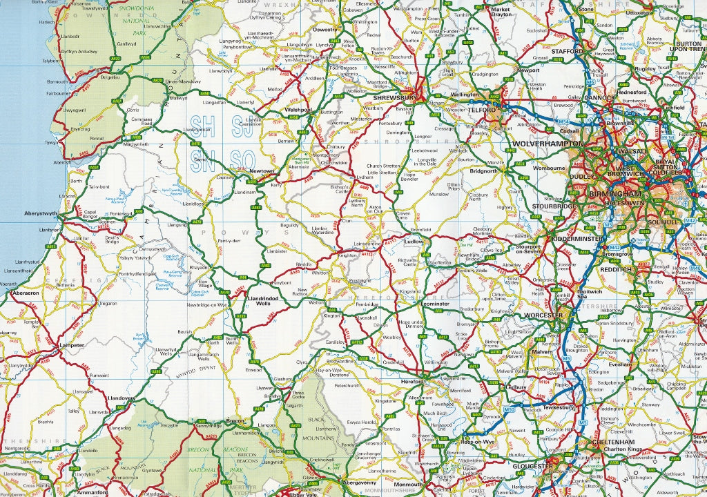
Britain AA Map 10
$19.95
Afterpay is only available for orders between $50.00 and $1000.00 More info
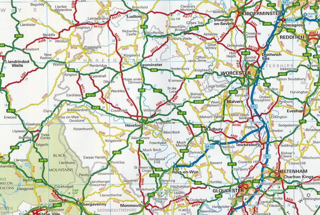
A detailed and dependable road map of Great Britain – essential for drivers, road trippers, caravanners, and classic map-lovers
The AA Road Map Britain 10 is part of the acclaimed AA Road Map series, offering a highly detailed, easy-to-read, and portable mapping solution for travellers exploring the length and breadth of Great Britain. Published in May 2024 by AA Publishing, this fully updated edition combines the trusted cartographic precision the AA is known for with practical design features ideal for planning, navigating, and discovering both major routes and scenic byways.
Whether you're embarking on a cross-country adventure, touring by caravan, or simply navigating unfamiliar regions, this fold-out map is the go-to glovebox companion for confident travel in England, Scotland, and Wales.
🗺️ Key Features & Benefits
📏 Clear and Accurate Scale
-
Scale: 1:200,000 (3 miles to 1 inch)
-
This scale offers the perfect balance between wide regional coverage and the ability to see detail such as minor roads, small towns, and key junctions.
-
🚗 Comprehensive Road Network Detail
-
All motorways, A-roads, B-roads, and minor routes clearly marked and labelled
-
Motorway junction numbers, toll points, service areas, and rest stops indicated
-
New road schemes and recent infrastructure updates included
🧭 Travel-Ready Information
-
Caravan and camping site locations for the self-guided traveller
-
National parks clearly outlined and named – including the Lake District, Snowdonia, and Cairngorms
-
Major tourist attractions, historic sites, and viewpoints marked for easy trip planning
-
Includes a special inset map of London’s M25 orbital route for navigating the capital
🏙️ City & Town Plans
-
Inset plans of major urban areas, providing additional detail for:
-
City centres
-
Key road links
-
Primary access routes
-
Navigation around congested regions
-
🔍 User-Friendly Layout
-
Folded map format – compact and convenient to store in a glovebox, map pouch, or travel bag
-
Easy-to-read fonts and colour-coded roads
-
Extensive place name index and route planner guide included on reverse
-
Ideal for quick lookups, on-the-go planning, or backup navigation
📘 Specifications
-
Title: Road Map Britain 10 (AA Road Map Series)
-
Edition: 2024
-
Publication Date: 23 May 2024
-
Publisher: AA Publishing
-
ISBN: 9780749584153
-
Open Dimensions: Approx. 120 cm x 98 cm
-
Folded Dimensions: Approx. 24.5 cm x 11 cm x 1.5 cm
-
Weight: ~96 g
-
Material: Durable paper stock with a smooth matte finish
🎯 Ideal For:
-
British road trippers and commuters wanting a physical, always-on backup to digital GPS
-
Tourists and caravanners exploring rural routes, national parks, and scenic drives
-
Professional drivers and delivery planners who value large-scale mapping with up-to-date information
-
Students, teachers, and travellers who appreciate having a physical overview of the UK road system
-
Map lovers and those nostalgic for classic navigation
✅ Why Choose an AA Road Map?
-
Produced by the Automobile Association (AA) – the UK’s most trusted name in motoring and mapping for over 100 years
-
Designed with motorists in mind: clear, detailed, and made for real-world road conditions
-
Always up-to-date with the latest road changes and tourist info
-
No batteries required – the perfect backup when GPS fails or signal drops
Compact. Clear. Travel-tested.
Whether you’re planning a summer holiday to the Highlands, navigating the back roads of Wales, or simply keeping a backup in your car for peace of mind, the AA Road Map Britain 10 is a practical, reliable, and affordable tool for anyone travelling across the UK.
Don’t hit the road without it.
SHIPS FROM AUSTRALIA, NEXT DAY SHIPPING
Frequently Asked Questions
Where can I buy the Britain AA Map 10?
The Britain AA Map 10 is available to buy online from Mapworld, Australia's largest map and geographic product retailer, with fast shipping Australia-wide.
Is the Britain AA Map 10 in stock at Mapworld?
Mapworld maintains extensive stock across its map range and aims for fast dispatch. Orders placed before 2pm AEST on business days are typically dispatched the same day, with standard and express Australia-wide delivery options available.
What is Mapworld's returns policy?
Mapworld accepts returns on undamaged items in original condition. Contact Mapworld within 90 days of purchase to arrange a return or exchange.
Does Mapworld ship the Britain AA Map 10 across Australia?
Yes, Mapworld ships Australia-wide. Standard shipping is a flat $7 rate, with free standard shipping on orders over $75. Express options are available at checkout. Most orders placed before 2pm AEST on weekdays are dispatched same day.
Related Items


© 2026 Mapworld. Website designed by Genie Media
X