- Australia ▾
- Topographic
▾
- Australia AUSTopo 250k (2025)
- Australia 50k Geoscience maps
- Australia 100k Geoscience maps
- Australia 250k Geoscience maps
- Australia 1:1m Geoscience maps
- New Zealand 50k maps
- New Zealand 250k maps
- New South Wales 25k maps
- New South Wales 50k maps
- New South Wales 100k maps
- Queensland 10k maps
- Queensland 25k maps
- Queensland 50k maps
- Queensland 100k maps
- Western Australia 25k maps
- Western Australia 50k maps
- Western Australia 100k maps
- Compasses
- Software
- GPS Systems
- International ▾
- Wall Maps
▾
- World
- Australia & New Zealand
- Countries, Continents & Regions
- Historical
- Vintage National Geographic
- Australian Capital Territory
- New South Wales
- Northern Territory
- Queensland
- South Australia
- Tasmania
- Victoria
- Western Australia
- Celestial
- Children's
- Mining & Resources
- Wine Maps
- Healthcare
- Postcode Maps
- Electoral Maps
- Nautical ▾
- Flags
▾
- Australian Flag Sets & Banners
- Flag Bunting
- Handwavers
- Australian National Flags
- Aboriginal Flags
- Torres Strait Islander Flags
- International Flags
- Flagpoles & Accessories
- Australian Capital Territory Flags
- New South Wales Flags
- Northern Territory Flags
- Queensland Flags
- South Australia Flags
- Tasmania Flags
- Victoria Flags
- Western Australia Flags
- Gifts ▾
- Globes ▾
Dear valued customer. Please note that our checkout is not supported by old browsers. Please use a recent browser to access all checkout capabilities


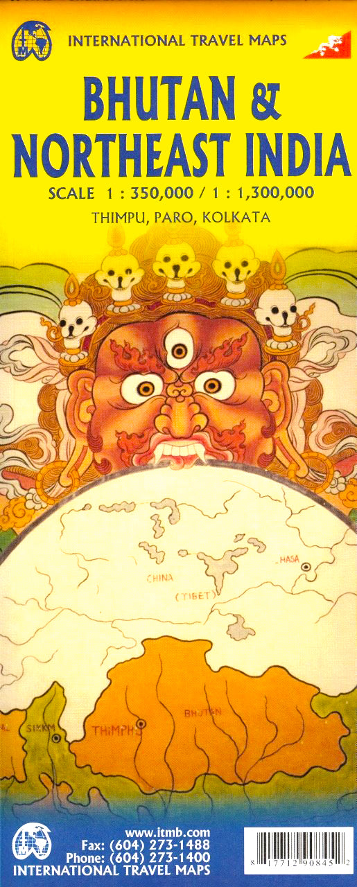
Bhutan & North East India ITMB Map
$24.95
Afterpay is only available for orders between $50.00 and $1000.00 More info
Double-Sided | Detailed | Laminated Option Available
Explore two of the most fascinating and least-travelled regions in South Asia with this beautifully detailed, double-sided travel map from International Travel Maps (ITMB). This 5th edition map offers updated cartographic coverage of the Kingdom of Bhutan on one side, and the remote North Eastern states of India on the other—perfect for adventurers, scholars, cultural travellers, and tour leaders alike.
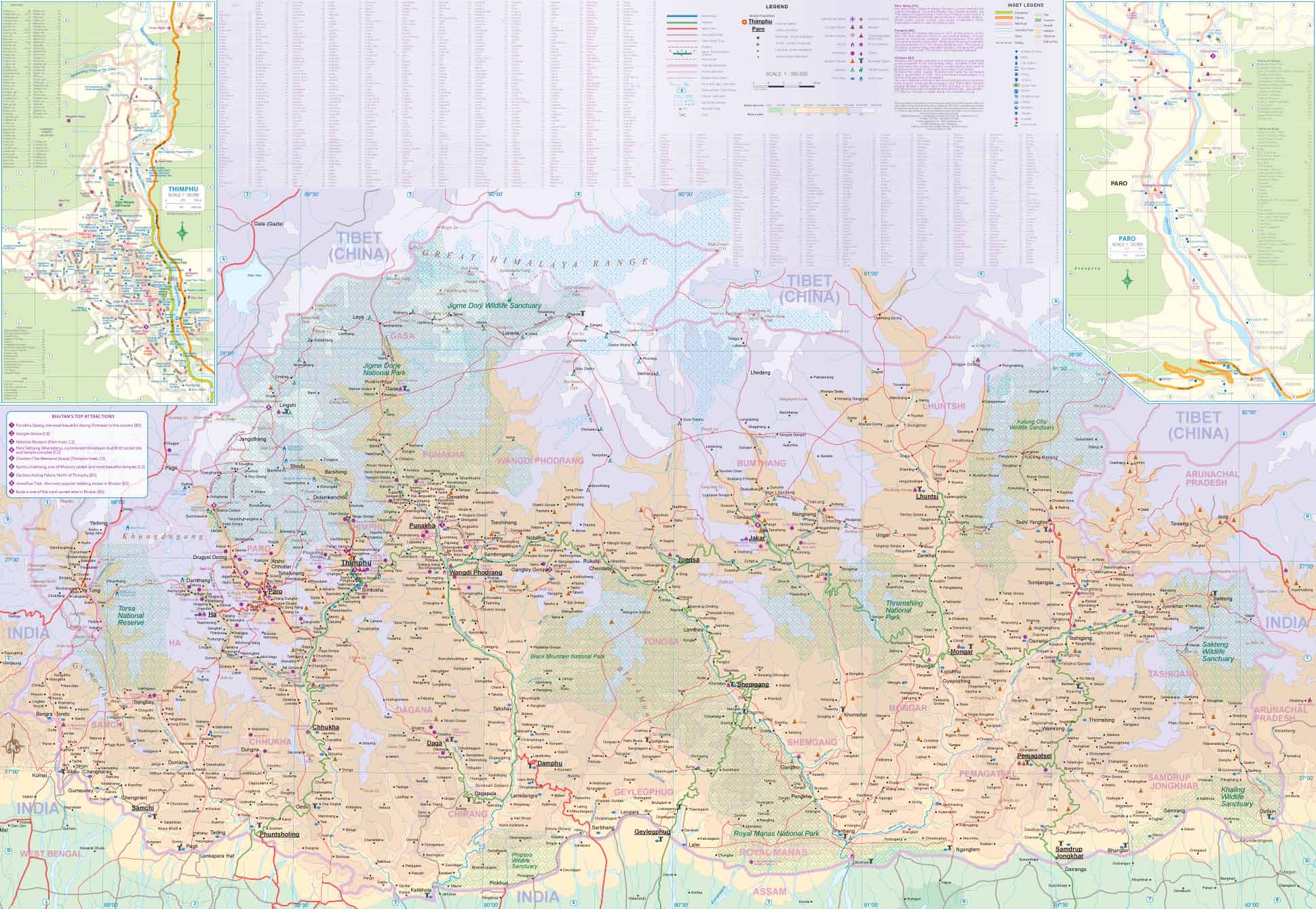
📍 Side 1: Bhutan (Scale 1:350,000)
Nestled in the eastern Himalayas, Bhutan remains one of the most exclusive travel destinations in the world—renowned for its environmental stewardship, Gross National Happiness policy, and spiritual depth.
This side of the map includes:
-
✅ Full country coverage with political boundaries, national parks, and protected areas
-
✅ Inset maps of the capital city Thimphu and gateway town Paro
-
✅ Road networks, trekking trails, elevation shading, rivers, and towns
-
✅ Major dzongs, monasteries, cultural landmarks, and scenic viewpoints
-
✅ Ideal for understanding the layout of this unique country, especially given its restricted tourism policy requiring minimum daily expenditures
Whether you're visiting the famous Tiger’s Nest Monastery or exploring the Bumthang Valley, this map will serve as a reliable planning companion and keepsake.
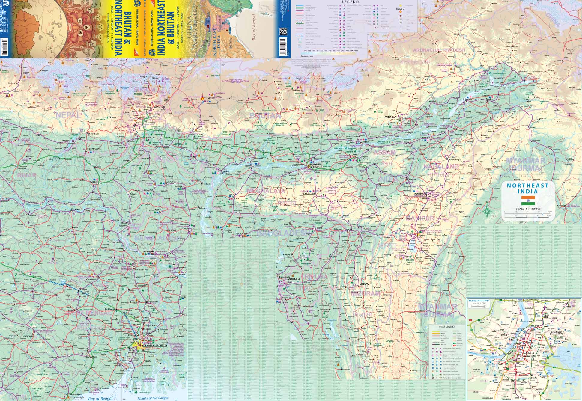
🌄 Side 2: North East India (Scale 1:1,300,000)
The reverse side offers a richly detailed overview of India’s north-eastern frontier, stretching from Kolkata in West Bengal up through Sikkim, Assam, Arunachal Pradesh, and the tribal regions bordering Myanmar, China, and Bhutan.
-
🛣️ Road networks with primary and secondary highways
-
🛤️ Railway lines and ferry routes
-
🏞️ Rivers, mountain ranges, and elevation shading
-
🏛️ Regional capitals, towns, cultural sites, and wildlife areas
-
🧭 Includes Kolkata, Guwahati, Itanagar, Imphal, Shillong, Aizawl, and more
-
🌏 Clear boundary demarcations—highlighting the politically sensitive borders with China (not the inaccurate claims often shown on Chinese-published maps)
This side is perfect for intrepid travellers looking to explore remote cultural pockets, national parks such as Kaziranga, and tribal heritage trails through Nagaland, Manipur, and Mizoram.
🛡️ Laminated Edition (Optional Upgrade)
For rugged use or permanent display, choose our laminated option, which transforms your map into a long-lasting, interactive planning tool:
-
✔️ Printed on high-quality paper, then flattened and encapsulated in 80-micron gloss laminate
-
✔️ Whiteboard-friendly – mark trails, itineraries, and locations with erasable markers
-
✔️ Water-resistant and tear-proof – perfect for humid, rainy, or dusty conditions
-
✔️ Ideal for classroom use, travel agencies, expedition teams, or wall-mounted travel inspiration
📌 Note: As the map is folded prior to lamination, very faint original fold lines may still be visible.
📐 Specifications
| Feature | Detail |
|---|---|
| Map Title | Bhutan & North East India |
| Publisher | International Travel Maps (ITMB) |
| Edition | 5th Edition |
| Map Type | Double-sided, folded |
| Scales | Bhutan 1:350,000 / NE India 1:1,300,000 |
| Size (Unfolded) | 680 mm (w) × 990 mm (h) |
| Paper Type | Standard map paper or optional lamination |
| Insets | Thimphu, Paro, major borders & rivers |
🌏 Why Choose This Map?
-
🔎 Up-to-date cartographic detail for two rarely mapped regions
-
🧳 Ideal for guided tours, trekking expeditions, and research
-
🧭 Great for route planning, classroom use, or wall display
-
🎁 Makes a unique and informative gift for globetrotters and map lovers
-
✅ Combines cultural insight with practical travel utility
🚚 Shipping & Delivery
📦 This map is printed and laminated to order. Please allow up to 10 business days for laminated maps to be prepared and dispatched.
Whether you're dreaming of Himalayan serenity or preparing for a border-crossing adventure through India’s remote northeast, this map offers the clarity, depth, and durability you need. Add it to your travel collection or wall today.
Frequently Asked Questions
Where can I buy the Bhutan & North East India ITMB Map?
The Bhutan & North East India ITMB Map is available to buy online from Mapworld, Australia's largest map and geographic product retailer, with fast shipping Australia-wide.
Is the Bhutan & North East India ITMB Map in stock at Mapworld?
Mapworld maintains extensive stock across its map range and aims for fast dispatch. Orders placed before 2pm AEST on business days are typically dispatched the same day, with standard and express Australia-wide delivery options available.
What is Mapworld's returns policy?
Mapworld accepts returns on undamaged items in original condition. Contact Mapworld within 90 days of purchase to arrange a return or exchange.
Does Mapworld ship the Bhutan & North East India ITMB Map across Australia?
Yes, Mapworld ships Australia-wide. Standard shipping is a flat $7 rate, with free standard shipping on orders over $75. Express options are available at checkout. Most orders placed before 2pm AEST on weekdays are dispatched same day.
Related Items


© 2026 Mapworld. Website designed by Genie Media
X