- Australia ▾
- Topographic
▾
- Australia AUSTopo 250k (2024)
- Australia 50k Geoscience maps
- Australia 100k Geoscience maps
- Australia 250k Geoscience maps
- Australia 1.1m Geoscience maps
- New Zealand 50k maps
- New Zealand 250k maps
- New South Wales 25k maps
- New South Wales 50k maps
- New South Wales 100k maps
- Queensland 10k maps
- Queensland 25k maps
- Queensland 50k maps
- Queensland 100k maps
- Compasses
- Software
- GPS Systems
- Orienteering
- International ▾
- Wall Maps
▾
- World
- Australia & New Zealand
- Countries, Continents & Regions
- Historical
- Vintage National Geographic
- Australian Capital Territory
- New South Wales
- Northern Territory
- Queensland
- South Australia
- Tasmania
- Victoria
- Western Australia
- Celestial
- Children's
- Mining & Resources
- Wine Maps
- Healthcare
- Postcode Maps
- Electoral Maps
- Nautical ▾
- Flags
▾
- Australian Flag Sets & Banners
- Flag Bunting
- Handwavers
- Australian National Flags
- Aboriginal Flags
- Torres Strait Islander Flags
- International Flags
- Flagpoles & Accessories
- Australian Capital Territory Flags
- New South Wales Flags
- Northern Territory Flags
- Queensland Flags
- South Australia Flags
- Tasmania Flags
- Victoria Flags
- Western Australia Flags
- Gifts ▾
- Globes ▾
Dear valued customer. Please note that our checkout is not supported by old browsers. Please use a recent browser to access all checkout capabilities


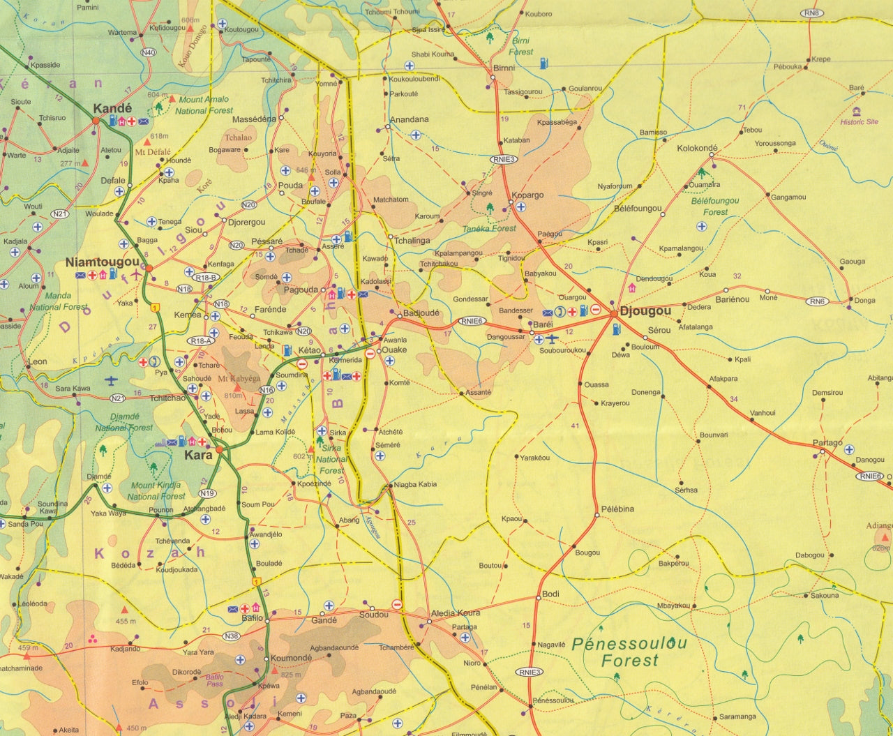
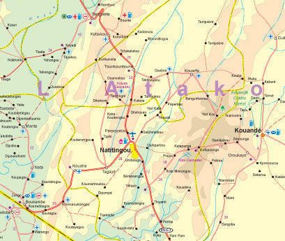
Benin & Togo ITMB Map
$24.95
Afterpay is only available for orders between $50.00 and $1000.00 More info
Double-Sided • 6th Edition • Laminatable Option Available
Explore the historical and geographical landscapes of Benin and Togo with this detailed and up-to-date map by ITMB. These two West African nations, nestled between Ghana and Nigeria, are rich in colonial history, vibrant cultures, and unique travel experiences. This travel reference map offers excellent cartographic detail, clear road networks, and helpful insets for city navigation and tourist highlights.
Whether you're venturing through the coastal capitals or heading inland toward traditional villages and national parks, this is the ideal planning tool for cultural explorers, overlanders, and curious travellers alike.
🗺️ Map Features at a Glance
| Feature | Description |
|---|---|
| Scale | 1:580,000 |
| Map Dimensions | 680 mm x 990 mm |
| Format | Double-sided map (Benin and Togo) |
| Insets Included | Lomé (Togo Capital), Porto-Novo (Benin Capital) |
| Top Attractions | Highlighted for both Benin and Togo in easy-to-read inset boxes |
| Borders & Crossings | Shows all international borders, including key land crossings |
🌍 Geopolitical & Travel Context
-
Togo was once a German colony until the end of World War I, after which it was jointly administered by Britain and France before becoming a French mandate.
-
Benin, formerly known as Dahomey, was part of the French colonial empire and gained Togo as a neighbouring French territory after Germany’s WWI defeat.
-
Despite their proximity, the two nations developed distinct cultures and administrative systems and have limited east-west connectivity, with most infrastructure built in north-south corridors.
🧭 Why This Map Is Useful
-
Updated road and rail networks, including regional highways and local routes
-
Clear city plans of Lomé and Porto-Novo to assist with urban navigation
-
Locations of national parks, historic sites, and tourist routes
-
Perfect for overland travellers, aid workers, expats, and cultural tourists
-
Top sights and highlights for each country included in dedicated call-out boxes
🛡️ Lamination Option Available
✅ Whiteboard-friendly surface – mark your route with erasable markers
✅ Durability – protects against water, wear, and tears
✅ Encapsulation – map is carefully flattened and sealed in high-quality 80-micron laminate
📌 Note: Some fold lines from the original folded map may still be faintly visible through the lamination.
🇧🇯 🇹🇬 Perfect For
-
Travellers exploring West Africa’s cultural heritage
-
NGOs and professionals working in regional development
-
Students or researchers focused on post-colonial African history
-
Anyone seeking a detailed, practical and durable map of Benin and Togo
Discover the contrasts and common threads between two neighbouring nations—Benin & Togo—through this expertly produced and richly detailed travel map.


