- Australia ▾
- Topographic
▾
- Australia AUSTopo 250k (2024)
- Australia 50k Geoscience maps
- Australia 100k Geoscience maps
- Australia 250k Geoscience maps
- Australia 1.1m Geoscience maps
- New Zealand 50k maps
- New Zealand 250k maps
- New South Wales 25k maps
- New South Wales 50k maps
- New South Wales 100k maps
- Queensland 10k maps
- Queensland 25k maps
- Queensland 50k maps
- Queensland 100k maps
- Compasses
- Software
- GPS Systems
- Orienteering
- International ▾
- Wall Maps
▾
- World
- Australia & New Zealand
- Countries, Continents & Regions
- Historical
- Vintage National Geographic
- Australian Capital Territory
- New South Wales
- Northern Territory
- Queensland
- South Australia
- Tasmania
- Victoria
- Western Australia
- Celestial
- Children's
- Mining & Resources
- Wine Maps
- Healthcare
- Postcode Maps
- Electoral Maps
- Nautical ▾
- Flags
▾
- Australian Flag Sets & Banners
- Flag Bunting
- Handwavers
- Australian National Flags
- Aboriginal Flags
- Torres Strait Islander Flags
- International Flags
- Flagpoles & Accessories
- Australian Capital Territory Flags
- New South Wales Flags
- Northern Territory Flags
- Queensland Flags
- South Australia Flags
- Tasmania Flags
- Victoria Flags
- Western Australia Flags
- Gifts ▾
- Globes ▾
Dear valued customer. Please note that our checkout is not supported by old browsers. Please use a recent browser to access all checkout capabilities


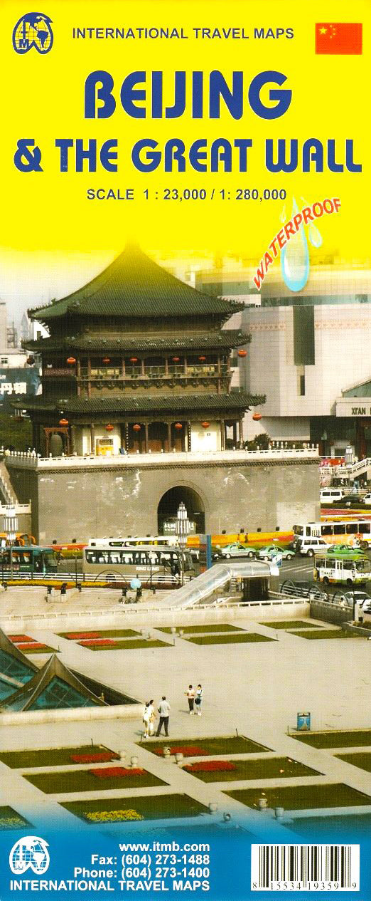
Beijing & The Great Wall ITMB - China Map
$24.95
Afterpay is only available for orders between $50.00 and $1000.00 More info
Updated Edition | Double-Sided | Durable Travel Companion
Explore China’s monumental capital and its most legendary UNESCO World Heritage Site with this double-sided Beijing & The Great Wall map by ITMB (International Travel Maps). Designed for travellers, educators, and culture lovers alike, this beautifully detailed map delivers a wealth of cartographic and cultural information on one convenient sheet — whether you’re navigating the wide boulevards of Beijing or trekking the ancient stones of the Great Wall.
🗺️ Map Overview
| Feature | Detail |
|---|---|
| Publisher | ITMB – International Travel Maps |
| Regions Covered | Beijing City + The Great Wall area |
| Map Type | Double-sided, folded map |
| Optional Finish | Available laminated (see below) |
| Size (flat) | 690 mm (w) x 1000 mm (h) |
| Scales | 1:23,000 (Beijing) / 1:280,000 (Wall area) |
| Language | English with local naming conventions |
| Edition | Updated post-2008 Olympics infrastructure |
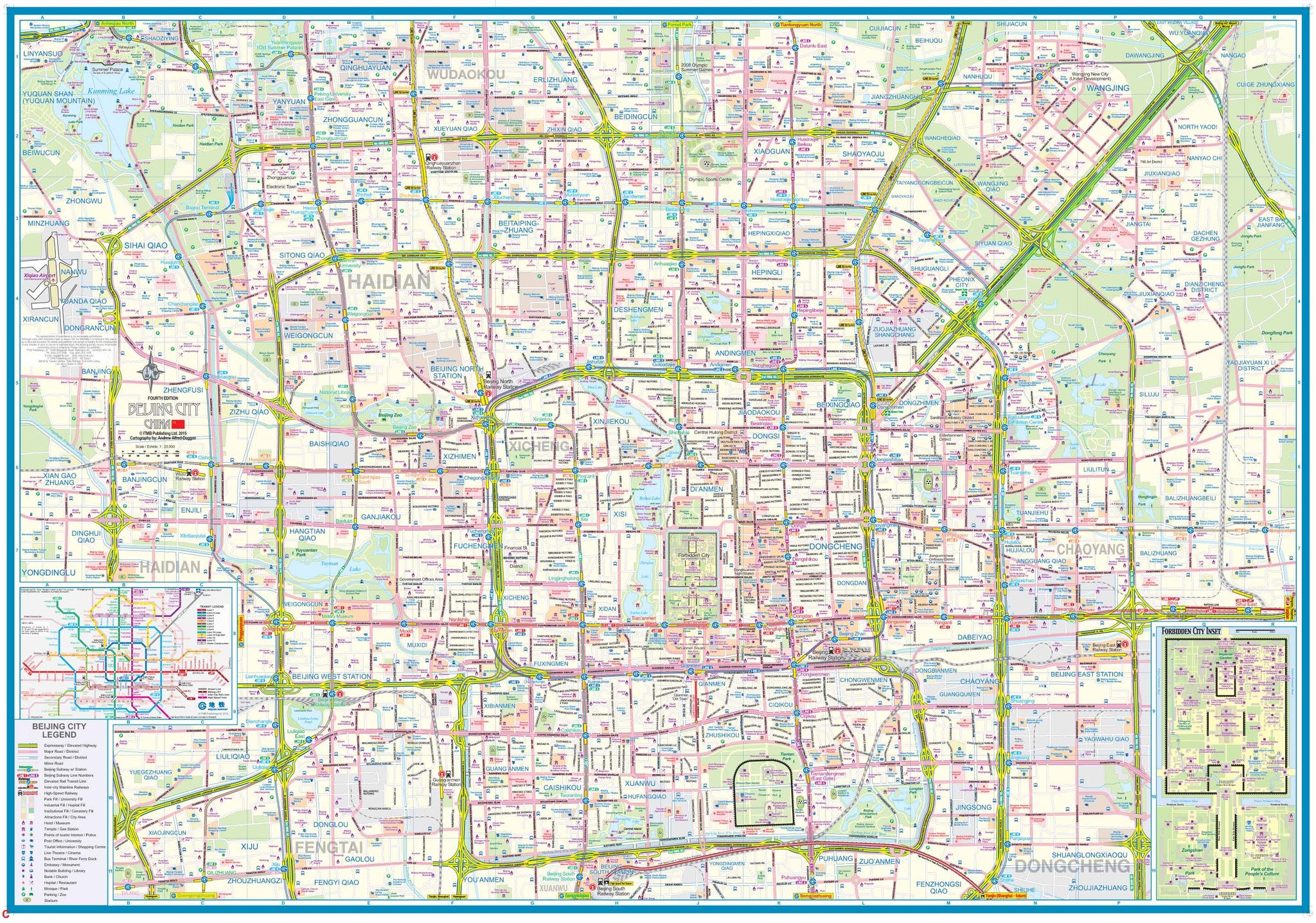
🏙️ Side A: Beijing City Map (Scale 1:23,000)
An up-to-date and richly detailed street map of central Beijing, China’s vast and vibrant capital.
Highlights include:
-
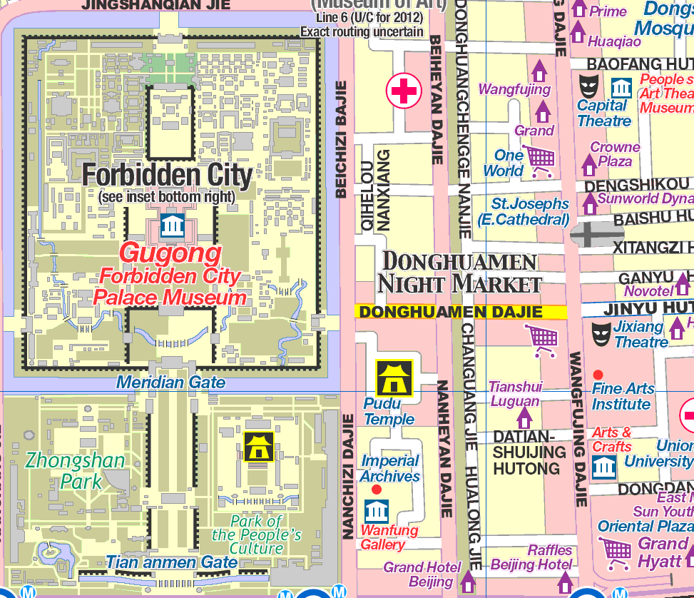
Major tourist attractions: Forbidden City, Temple of Heaven, Summer Palace, Lama Temple, Olympic Park
-
Tiananmen Square and the Great Hall of the People
-
Subway system with new lines, including Line 4 and planned expansions
-
Parks, gardens, lakes, museums, and traditional hutong neighbourhoods
-
Embassies, hospitals, shopping districts, universities, and cultural centres
-
Central business districts and iconic skyscrapers of modern Beijing
-
Clear street indexing and bilingual naming for ease of navigation
Whether you’re sightseeing, shopping, or exploring on foot, this side of the map offers a full city view and practical travel information.
🏯 Side B: The Great Wall of China & Regional Map (Scale 1:280,000)
Journey beyond the city and follow the serpentine spine of one of the world’s greatest architectural achievements — the Great Wall of China.
Features include:
-
Detailed mapping of key sections of the Wall, including:
-
Badaling, Mutianyu, Juyongguan, Jiankou, Simatai, and more
-
-
Areas showing collapsed or unrestored segments of the Wall
-
The Ming Tombs, an important historical complex near Changping
-
Marco Polo Bridge, historically significant in East–West exploration
-
Towns and villages along the Wall route for staging excursions
-
Scenic roads and access routes to trailheads and lookout points
Whether you're hiking the battlements or learning from afar, this side offers a vivid cartographic narrative of China's ancient frontier.
🔒 Optional Lamination Upgrade
Enhance durability and usability with our professional lamination service:
✅ Writeable surface for whiteboard markers – ideal for trip planning
✅ Compatible with map dots – mark where you’ve been or plan to go
✅ Water-resistant and tear-resistant – protects against weather and spills
✅ Gloss finish enhances colours and visibility
Please note: Laminated maps are created by flattening and encapsulating the folded map in two sheets of 80-micron gloss laminate. Slight fold lines will still be visible but will not affect usability or aesthetics.
📍 Ideal For
-
✈️ Tourists planning to explore Beijing and the Great Wall
-
🎒 Backpackers and hikers trekking iconic segments of the Wall
-
🧭 Educators and students studying Chinese history and geography
-
🏡 Decorative use in homes, classrooms, or cultural institutions
-
📚 Guidebook companions and on-the-ground navigation
🔍 Why Choose This Map?
-
🎯 Dual Focus: Offers two major travel experiences on one sheet
-
🧭 Accurate, up-to-date cartography by a trusted map publisher
-
🧳 Folded for convenience, or upgrade to laminated for field use
-
📚 Informative, attractive, and ready for your next adventure
📦 Product Options
| Format | Description |
|---|---|
| Folded Paper Map | Lightweight, compact, ideal for casual travellers |
| Laminated Map | Durable, waterproof, suitable for daily handling or display |
Follow the footsteps of emperors, explorers, and dynasties — from the heart of Beijing to the winding ridges of the Great Wall.


