- Australia ▾
- Topographic
▾
- Australia AUSTopo 250k (2024)
- Australia 50k Geoscience maps
- Australia 100k Geoscience maps
- Australia 250k Geoscience maps
- Australia 1.1m Geoscience maps
- New Zealand 50k maps
- New Zealand 250k maps
- New South Wales 25k maps
- New South Wales 50k maps
- New South Wales 100k maps
- Queensland 10k maps
- Queensland 25k maps
- Queensland 50k maps
- Queensland 100k maps
- Compasses
- Software
- GPS Systems
- Orienteering
- International ▾
- Wall Maps
▾
- World
- Australia & New Zealand
- Countries, Continents & Regions
- Historical
- Vintage National Geographic
- Australian Capital Territory
- New South Wales
- Northern Territory
- Queensland
- South Australia
- Tasmania
- Victoria
- Western Australia
- Celestial
- Children's
- Mining & Resources
- Wine Maps
- Healthcare
- Postcode Maps
- Electoral Maps
- Nautical ▾
- Flags
▾
- Australian Flag Sets & Banners
- Flag Bunting
- Handwavers
- Australian National Flags
- Aboriginal Flags
- Torres Strait Islander Flags
- International Flags
- Flagpoles & Accessories
- Australian Capital Territory Flags
- New South Wales Flags
- Northern Territory Flags
- Queensland Flags
- South Australia Flags
- Tasmania Flags
- Victoria Flags
- Western Australia Flags
- Gifts ▾
- Globes ▾
Dear valued customer. Please note that our checkout is not supported by old browsers. Please use a recent browser to access all checkout capabilities


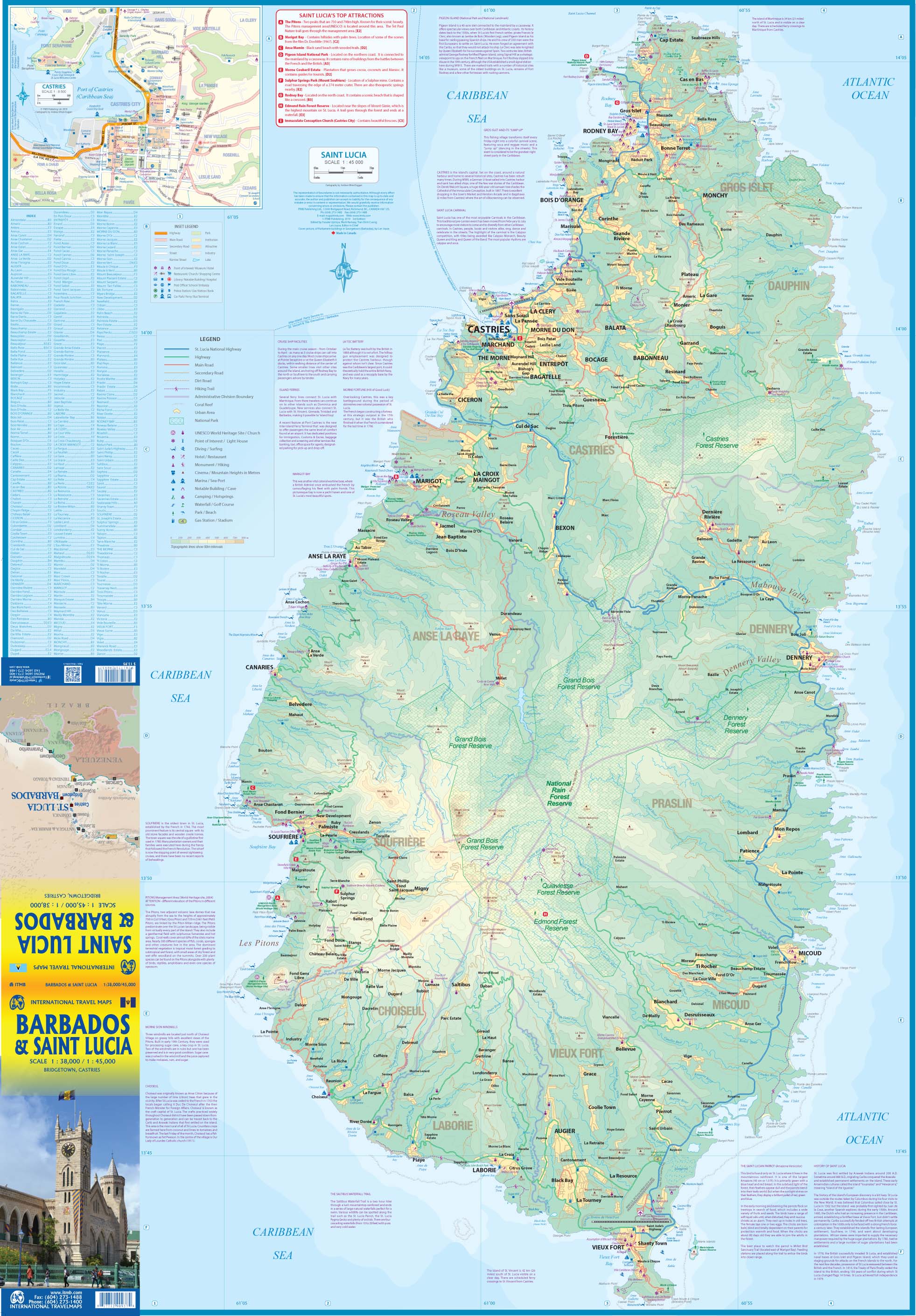
Barbados & St Lucia ITMB Map
$24.95
Afterpay is only available for orders between $50.00 and $1000.00 More info
Double-Sided | 1:38,000 & 1:45,000 | Cruise & Island Explorer’s Favourite
Size: 990 mm x 680 mm | Full Colour Folded Map
Explore two of the Caribbean’s most enchanting islands with this Barbados & St. Lucia Map by ITMB, a double-sided, travel-ready resource designed for independent travellers, cruise guests, and island lovers alike. Covering both islands in rich topographic detail, this 3rd Edition includes city insets, resort areas, airports, ports, and tourist highlights—making it perfect for pre-trip planning or on-the-go navigation.
Whether you’re hiking rainforest trails in Saint Lucia or touring heritage sites in Barbados, this map offers clarity, accuracy, and local insight.
🌴 What's Covered?
🔹 Side 1 – St. Lucia (Scale 1:45,000)
-
Full-island map of St. Lucia, with emphasis on its dramatic topography
-
Inset map of Castries, the island’s capital and main cruise port
-
Highlights:
-
🌋 Rainforest-covered interior
-
✈️ Two airports (Hewanorra & George F. L. Charles)
-
🛳️ Cruise terminal at Castries with inter-island ferry access
-
🏖️ Resort hubs: Rodney Bay, Marigot Bay, Soufrière, Vieux Fort
-
🛣️ Main highway linking north and south
-
🔹 Side 2 – Barbados (Scale 1:38,000)
-
Detailed map of Barbados, showing its gentle terrain and beach-rich coastline
-
Inset map of Bridgetown, the island’s capital
-
Highlights:
-
✈️ Airport near the southeast coast (Grantley Adams International Airport)
-
🏖️ Resort clusters at St. Lawrence Gap, Holetown, and the West Coast
-
🚗 Scenic road routes criss-crossing the island
-
🏛️ Top 10 Attractions including:
-
Sunbury Plantation House (1660)
-
St. Nicholas Abbey (1658)
-
Gun Hill Signal Station (1818)
-
-
📌 Key Map Features
| Feature | Description |
|---|---|
| 🌍 Double-Sided Format | Saint Lucia on one side, Barbados on the other |
| 📏 Detailed Scales | St. Lucia: 1:45,000 / Barbados: 1:38,000 |
| 🏙️ City Insets | Includes Castries and Bridgetown for local navigation |
| ✈️ Airport & Port Info | All major cruise ports and airports clearly marked |
| 🏝️ Resort & Beach Areas | Highlighted across both islands |
| 🛣️ Road Networks | Highways, secondary roads, and key scenic routes |
| 📚 Historical Sites | Includes key heritage and colonial landmarks |
| 🌿 Natural Features | Rainforests, coastlines, bays, and mountains |
📐 Product Specifications
| Specification | Detail |
|---|---|
| Title | Barbados & St. Lucia Map |
| Publisher | ITMB – International Travel Maps |
| Edition | 3rd Edition |
| Format | Folded, double-sided travel map |
| Size | 990 mm (W) x 680 mm (H) (unfolded) |
| Scales | Barbados: 1:38,000 / St. Lucia: 1:45,000 |
| Full colour with shaded relief | |
| Paper Type | Durable, travel-grade paper |
🎯 Ideal For:
-
🚢 Cruise travellers exploring multiple islands in a single itinerary
-
🧭 Independent travellers & backpackers looking for self-guided touring options
-
🏖️ Beachgoers & resort visitors planning coastal stays
-
📚 Students & teachers studying Caribbean geography and history
-
🗺️ Map collectors & armchair travellers wanting a detailed visual guide
🛒 Add to Cart – Your Caribbean Adventure Starts Here
Whether you're hiking the Pitons of Saint Lucia or sipping rum on a sun-kissed beach in Barbados, this Barbados & St. Lucia Map by ITMB is your reliable companion for exploring two of the Caribbean’s most welcoming destinations.
📦 Lightweight, compact, and rich with information—perfect for cruise days, day trips, and pre-travel planning.


