- Australia ▾
- Topographic
▾
- Australia AUSTopo 250k (2025)
- Australia 50k Geoscience maps
- Australia 100k Geoscience maps
- Australia 250k Geoscience maps
- Australia 1:1m Geoscience maps
- New Zealand 50k maps
- New Zealand 250k maps
- New South Wales 25k maps
- New South Wales 50k maps
- New South Wales 100k maps
- Queensland 10k maps
- Queensland 25k maps
- Queensland 50k maps
- Queensland 100k maps
- Compasses
- Software
- GPS Systems
- Orienteering
- International ▾
- Wall Maps
▾
- World
- Australia & New Zealand
- Countries, Continents & Regions
- Historical
- Vintage National Geographic
- Australian Capital Territory
- New South Wales
- Northern Territory
- Queensland
- South Australia
- Tasmania
- Victoria
- Western Australia
- Celestial
- Children's
- Mining & Resources
- Wine Maps
- Healthcare
- Postcode Maps
- Electoral Maps
- Nautical ▾
- Flags
▾
- Australian Flag Sets & Banners
- Flag Bunting
- Handwavers
- Australian National Flags
- Aboriginal Flags
- Torres Strait Islander Flags
- International Flags
- Flagpoles & Accessories
- Australian Capital Territory Flags
- New South Wales Flags
- Northern Territory Flags
- Queensland Flags
- South Australia Flags
- Tasmania Flags
- Victoria Flags
- Western Australia Flags
- Gifts ▾
- Globes ▾
Dear valued customer. Please note that our checkout is not supported by old browsers. Please use a recent browser to access all checkout capabilities


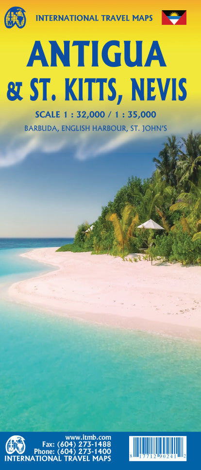
Antigua & St Kitts Nevis ITMB Map
$24.95
Afterpay is only available for orders between $50.00 and $1000.00 More info
Double-Sided | Detailed Caribbean Island Mapping | Includes Barbuda Inset
Size: 990 mm x 680 mm | Folded Travel Map
Discover the charm, history, and tropical beauty of the Eastern Caribbean with the Antigua & St. Kitts–Nevis Map by ITMB (International Travel Maps). This new combination edition offers detailed cartographic coverage of three island nations: Antigua, Barbuda, and the twin-island federation of St. Kitts and Nevis—perfect for travellers, sailors, or anyone exploring this vibrant part of the Caribbean.
🌴 What’s Included?
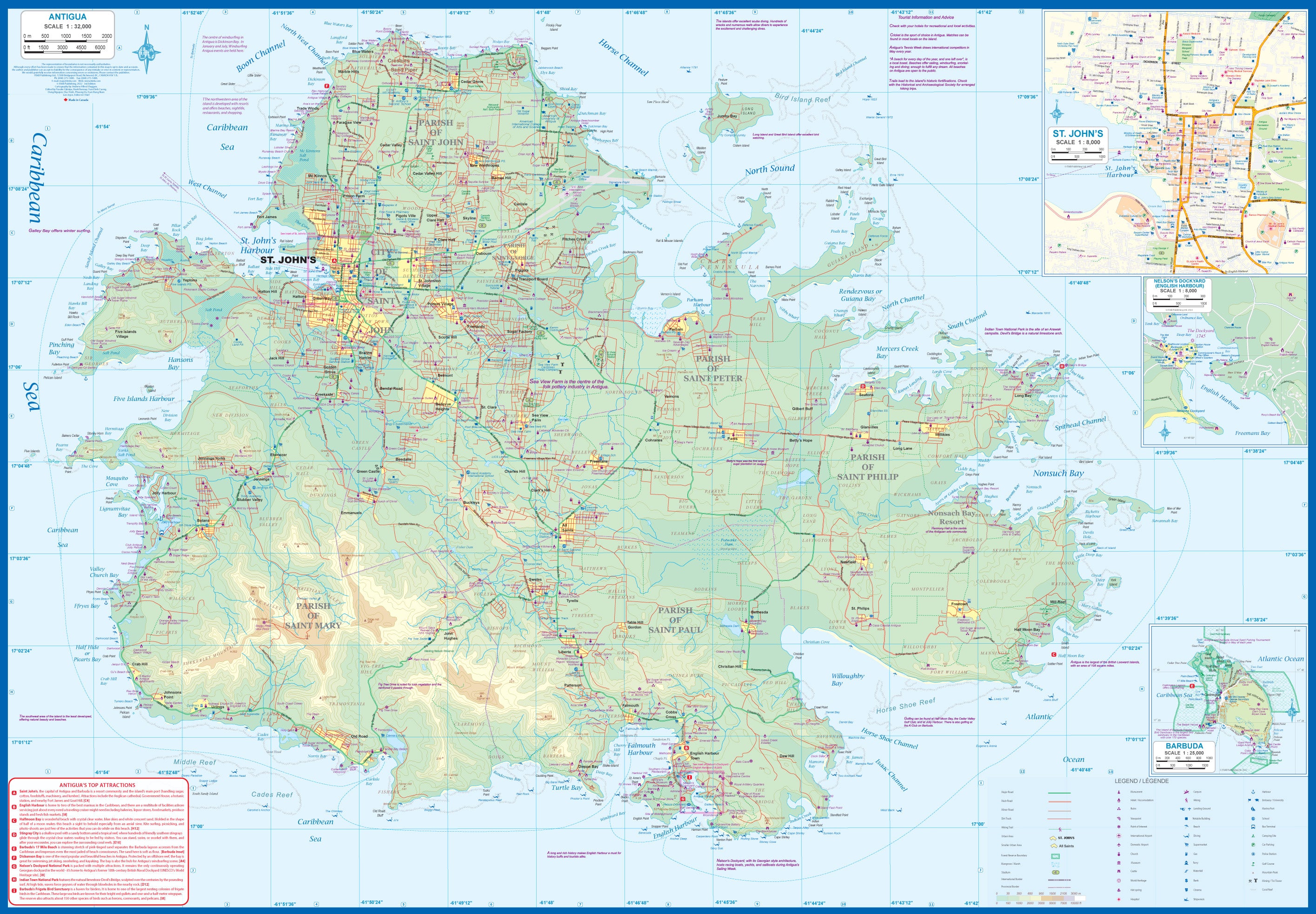
🔹 Side 1 – Antigua & Barbuda
-
Full island map of Antigua with updated detail
-
Inset map of St. John’s, the capital city
-
⚓ Features Nelson’s Dockyard at English Harbour—a historic British naval base
-
Inset of Barbuda, a quieter sister island with pristine beaches and coral reefs
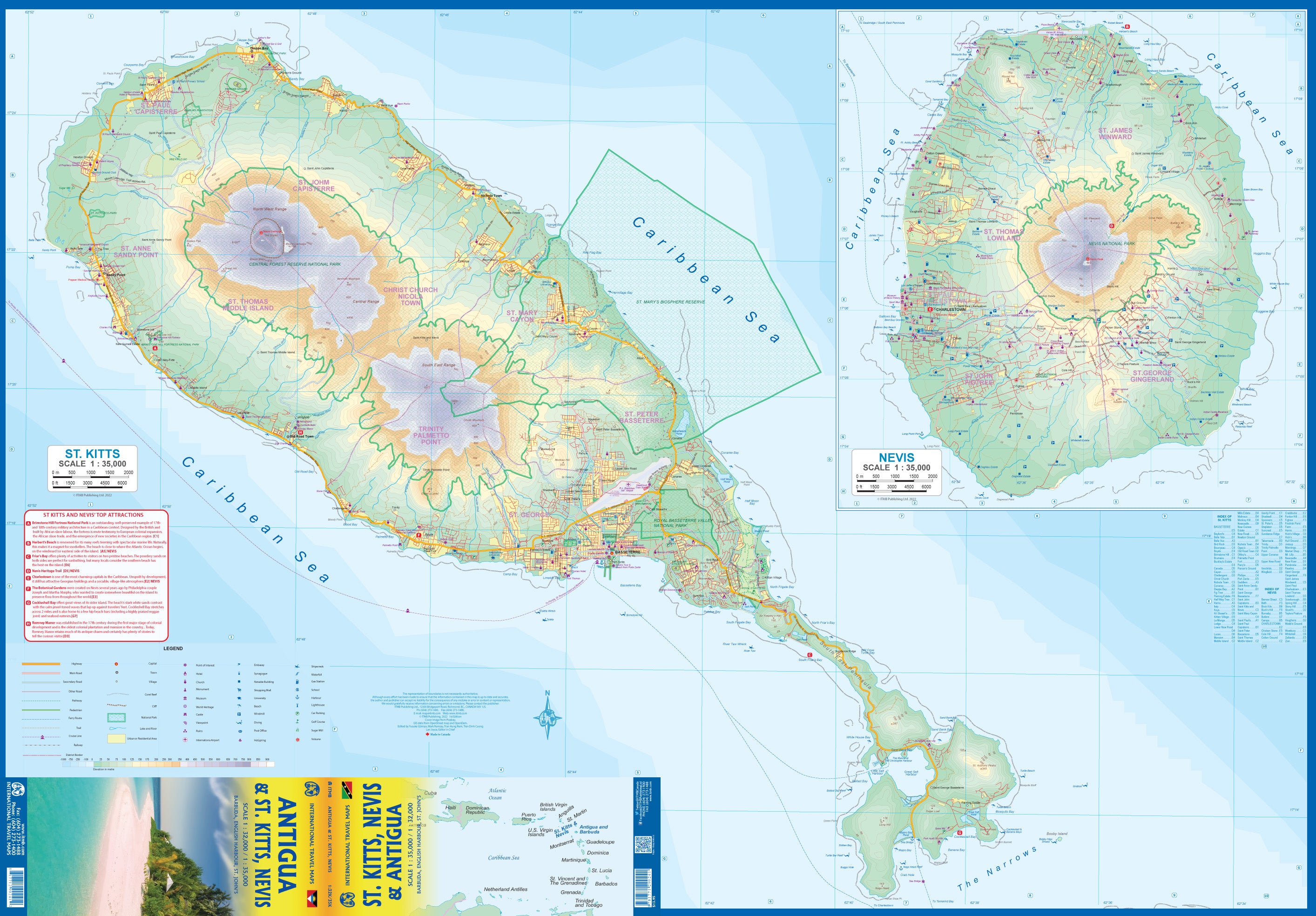
🔹 Side 2 – St. Kitts & Nevis
-
Full coverage of both islands, showing:
-
Main roads and secondary routes
-
Coastal features and urban areas
-
Tourist highlights, beaches, ferry routes, and hiking areas
-
📌 Key Features
| Feature | Description |
|---|---|
| 🗺️ Updated Cartography | Latest edition with refreshed digital data |
| 🌊 Multi-Island Coverage | Covers Antigua, Barbuda, St. Kitts, and Nevis |
| 🏙️ City Inset | St. John’s detailed inset for street-level navigation |
| 🏰 Cultural Sites | Includes Nelson’s Dockyard and other points of interest |
| 🛣️ Road Network | Clearly marked roads, routes, and ferry terminals |
| 📐 Practical Format | Compact and foldable – ideal for pockets, backpacks, or carry-ons |
| 🌍 Tourist Focused | Great for planning beach trips, city visits, or eco-adventures |
📐 Product Specifications
| Specification | Detail |
|---|---|
| Title | Antigua & St. Kitts–Nevis Map |
| Publisher | ITMB – International Travel Maps |
| Format | Double-sided folded map |
| Size | 990 mm (W) x 680 mm (H) (unfolded) |
| Edition | Latest available |
| Paper Type | Durable, high-quality travel paper |
| Full colour with shaded relief |
🎯 Who Is This Map For?
-
🧭 Island-hopping travellers exploring the Lesser Antilles
-
🛥️ Cruise ship guests visiting multiple islands in one trip
-
🧳 Independent adventurers & backpackers
-
🏖️ Tourists planning beach, heritage, or eco-experiences
-
📚 Students & educators looking for accurate island reference maps
-
🗺️ Map collectors & Caribbean enthusiasts
🛒 Plan Your Caribbean Escape with Confidence
From the cultural vibrancy of St. John’s to the volcanic landscapes of Nevis and the peaceful sands of Barbuda, the Antigua & St. Kitts–Nevis Map by ITMB brings the islands to life—whether you're exploring by road, boat, or backpack.
📦 Lightweight, easy to fold, and packed with up-to-date information—your perfect island companion awaits.
Frequently Asked Questions
Where can I buy the Antigua & St Kitts Nevis ITMB Map?
The Antigua & St Kitts Nevis ITMB Map is available to buy online from Mapworld, Australia's largest map and geographic product retailer, with fast shipping Australia-wide.
Is the Antigua & St Kitts Nevis ITMB Map in stock at Mapworld?
Mapworld maintains extensive stock across its map range and aims for fast dispatch. Orders placed before 2pm AEST on business days are typically dispatched the same day, with standard and express Australia-wide delivery options available.
What is Mapworld's returns policy?
Mapworld accepts returns on undamaged items in original condition. Contact Mapworld within 90 days of purchase to arrange a return or exchange.
Does Mapworld ship the Antigua & St Kitts Nevis ITMB Map across Australia?
Yes, Mapworld ships Australia-wide. Standard shipping is a flat $7 rate, with free standard shipping on orders over $75. Express options are available at checkout. Most orders placed before 2pm AEST on weekdays are dispatched same day.
Related Items


© 2026 Mapworld. Website designed by Genie Media
X